Subsurface Interpretation for Groundwater Potential Mapping Using Electrical Resistivity Tomography (ERT) in Mon Ikeun Village, Aceh Besar, Indonesia
DOI:
https://doi.org/10.25299/jgeet.2025.10.3.22580Keywords:
Groundwater, Clean Water Crisis, Mon Ikeun Village, Resistivity, GeophysicsAbstract
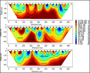
The Mon Ikeun Village area in Aceh Besar is experiencing a clean water crisis due to a prolonged drought, which has significantly impacted human needs and necessitates identifying alternative water sources. This study aims to determine groundwater potential in the area using the Electrical Resistivity Tomography method. Data acquisition was conducted along three survey lines, each 420 m long. The Wenner-Schlumberger configuration was employed, using 22 electrodes with a spacing of 20 m. Data processing was done using ResIPy software to generate 2D resistivity cross-sections representing the subsurface structure. The resistivity sections were interpreted by correlating them with regional geological data and secondary data from wells located near the study area. The results indicate that two different lithologies dominate the subsurface structure of the study area. The first is a conductive zone with resistivity values of ≤316.23 Ω.m, interpreted as alluvium composed of clay, sand, and gravel. The second is a resistive zone with resistivity values of ≥562.34 Ω.m, interpreted as bedrock composed of limestone. Based on the subsurface lithology, zones with groundwater potential are found in conductive areas with resistivity values ranging from 3.16 to 56.23 Ω.m, which are associated with water-saturated alluvial layers, particularly those dominated by clay and sand. From the 2D resistivity cross-sections analysis, line 3 shows the highest potential for groundwater exploration, with water-saturated layers occurring at both shallow and deeper depths, reaching up to 0–40 m. This study provides valuable information for water resource management in Mon Ikeun Village, especially in addressing future clean water shortages.
Downloads
References
Adagunodo, A., and Sunmonu, A., 2013. The study of basement pattern of an industrial estate. Saarbrucken: LAP Lambert Academic Publishing GmbH & Co. KG Heinrich-Bocking.
Adagunodo, T.A., Sunmonu, L.A., Oladejo, O.P., 2014. Effect of constructing high-rise buildings without a geophysical survey. Nigerian Journal of Physics 91-100.
Adagunodo, T.A., Akinloye, M.K., Sunmonu, L. A., Aizebeokhai, A.P., Oyeyemi, K.D., & Abodunrin, F.O., 2018. Groundwater exploration in Aaba residential area of Akure, Nigeria. Frontiers in Earth Science 6, 66.
Attwa, M., and Zamzam, S., 2020. An integrated approach of GIS and geoelectrical techniques for wastewater leakage investigations: Active constraint balancing and genetic algorithms application. Journal of Applied Geophysics 175, 103992.
Bachtiar, M.A., CSSSA, B.Y., Firmansyah, Y., 2022. Pendugaan persebaran akuifer berdasarkan data geolistrik resistivitas 1D dan 2D di Daerah Cicalengka dan sekitarnya, Kabupaten Bandung, Provinsi Jawa Barat. Geoscience Journal 6(1), 658-664.
Bennett, J.D., Bridge, D.M., Cameron, N.R., Djunuddin, A., Ghazali, S.A., Jeffery, D.H., Kartawa, W., Keats, W., Rock, N.M.S., Thomson, S.J, and Whandoyo, R., 1981. Geologic map of the Banda Aceh quadrangle, Sumatra. Geol. Res. Dev. Cent., Bandung, Indonesia.
Brindha, K., & Elango, L., 2012. Groundwater quality zonation in a shallow weathered rock aquifer using GIS. Geo-Spatial Information Science, 15(1), 95-104.
Darmawan, S., Harmoko, U., Widada, S., 2014. Identifikasi struktur bawah permukaan menggunakan metode geolistrik konfigurasi schlumberger di area panasbumi Desa Diwak Dan Derekan Kecamatan Bergas Kabupaten Semarang. Youngster Physics Journal 3(2), 159-164.
Darisma, D., Fernanda, F., Syukri, M., 2020. Investigation of groundwater potential using Electrical Resistivity Method and Hydraulic Parameters in Lam Apeng, Aceh Besar, Indonesia. Journal of Geoscience, Engineering, Environment, and Technology 5(4), 185-190.
Daniswara, A., Dahrin, D., Setianingsih, S., 2020. Analysis and modelling of geoelectric data modeling for the identication of groundwater aquifer at Cisarua Area, West Bandung. Jurnal Geofisika 17(2), 22-25.
Fadli, A.I., Yuwanto, S.H., Bahar, H., 2020. Hidrogeologi dan kualitas air tanah Desa Sumber Banteng, Kecamatan Kejayan, Kabupaten Pasuruan, Jawa Timur. In Prosiding Seminar Teknologi Kebumian dan Kelautan 2 (1), 367-379.
Faisal, F., Putra, Y.S., Muhardi, M., 2022. Aplikasi metode geolistrik resistivitas untuk mengidentifikasi lapisan akuifer di Komplek Alam Mulia Serdam, Kabupaten Kubu Raya. Jurnal Fisika Unand 11(1), 22-28.
Joel, E.S., Olasehinde, P.I., De, D.K., Omeje, M., Adewoyin, O.O., 2016. Estimation of aquifer transmissivity from geo-physical data a case study of convenant university and environs, Sothwestern Nigeria. Science International 28(4).
Kayode, J.S., Adelusi, A.O., Nawawi, M.N.M., Bawallah, M., Olowolafe, T.S., 2016. Geo-electrical investigation of near surface conductive structures suitable for groundwater accumulation in a resistive crystalline basement environment: a case study of Isuada, southwestern Nigeria. Journal of African Earth Sciences 119, 289-302.
Larson, S., Kirono, D.G., Tjandraatmadja, G., Barkey, R., 2016. Monitoring and evaluation approaches in water resources project design: experiences from an urban water system climate change adaptation project in Indonesia. Water Policy 18(3), 708-726.
Loke, M.H., 2000. Electrical imaging surveys for environmental and enggineering studies: A partical Guide to 2D & 3D Electrical Imaging Surveys. Technical.
Loke, M.H., & Baker, R.D., 1996. Rapid least-squares inversion of apparent resistivity pseudesection by a quasi-Newton method1. Goephysical processing, 44(1), 131-152.
Mohamaden, M.I., and Ehab, D., 2017. Application of electrical resistivity for groundwater exploration in Wadi Rahaba, Shalateen, Egypt. NRIAG Journal of Astronomy and Geophysics 6(1), 201-209.
Mogaji, K.A., and Omobude, O.B., 2017. Modeling of geoelectric parameters for assessing groundwater potentiality in a multifaceted geologic terrain, Ipinsa Southwest, Nigeria–A GIS-based GODT approach. NRIAG Journal of Astronomy and Geophysics 6(2), 434-451.
Muzakki, Y., Lestrai, W., Fajar, M.H.M., Dwiharto, M.F., 2021. Pemodelan Akuifer Air Tanah Dengan Menggunakan Vertical Electrical Sounding (VES) Studi Kasus Kabupaten Sorong, Provinsi Papua Barat. Jurnal Geosaintek 7(3), 111-118.
Nigm, A.A., Elterb, R.A., Nasr, F.E., Thobaity, H.M., 2008. Contribution of Ground Magnetic and Resistivity Methods in Groundwater Assessment in Wadi Bany Omair, Holy Makkah Area, Saudi Arabia. Journal of Egyptian Geophysical Society 6(1), 67-79.
Oyeyemi, K.D., Aizebeokhai, A.P., Adagunodo, T.A., Olofinnade, O.M., Sanuade, O.A., Olaojo, A.A., 2017. Subsoil characterization using geoelectrical and geotechnical investigations: implications for foundation studies. International Journal of Civil Engineering and Technology 8(10), 302-314.
Setiawan, T., and Nasution, A.F., 2023. Predicting The Locations of Caves and Rock Shelters in Western Part of Aceh Karst Using Geographic Information System. KALPATARU 32(1), 1-12.
Singh, K.K.K., Bharti, A.K., Prakash, A., Saurabh, Kumar, R., & Singh, P.K., 2019. Delinetation of fracture zone groundwater using combined inversion technique. Environmental Earth Science, 78, 1-12.
Tabbagh, A., Dabas, M., Hesse, A., & Panissod, C., 2000. Soil resistivity: a non-invasive tool to map soil structure horizonation. Geoerma, 97(3-4), 393-404.
Triadi, T., and Indra, K., 2009. Permasalahan airtanah pada daerah urban. Teknik 30(1), 48-57.
Telford, W.M., Geldart, L.P., Sheriff, R.E., 1990. Applied geophysics. Cambridge university press.
Wahyuni, A., Massinai, M.F.I., Mun'im, A., Massinai, M.A., 2021. Resistivity method for characterising subsurface layers of coastal areas in South Sulawesi, Indonesia. Journal of Geoscience, Engineering, Environment, and Technology 6(4), 217-225.
Downloads
Published
Issue
Section
License
Copyright (c) 2025 Journal of Geoscience, Engineering, Environment, and Technology

This work is licensed under a Creative Commons Attribution-ShareAlike 4.0 International License.
Copyright @2019. This is an open-access article distributed under the terms of the Creative Commons Attribution-ShareAlike 4.0 International License which permits unrestricted use, distribution, and reproduction in any medium. Copyrights of all materials published in JGEET are freely available without charge to users or / institution. Users are allowed to read, download, copy, distribute, search, or link to full-text articles in this journal without asking by giving appropriate credit, provide a link to the license, and indicate if changes were made. All of the remix, transform, or build upon the material must distribute the contributions under the same license as the original.