Analysis of The Effect of Land Use Change Using Random Forest Algorithm on Surface Temperature and Its Relationship With Urban Heat Island Phenomenon
DOI:
https://doi.org/10.25299/jgeet.2026.11.1.22002Keywords:
Land Use, Random Forest, Surface Temperature, Urban Heat IslandAbstract
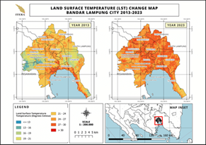
Bandar Lampung City is one of the cities experiencing rapid population growth. Its strategic location for development and infrastructure has made it a prime target for urbanisation. This urbanisation process has increased built-up land areas and surface temperature, triggering the emergence of the urban heat island (UHI) phenomenon. This study aims to analyse land use changes and surface temperature to determine the spatial distribution of the urban heat island phenomenon in Bandar Lampung City using Landsat 8 remote sensing data. The analysis was carried out through several extraction stages, one involved examining land use changes using the random forest algorithm as an ensemble learning method to address classification problems. The classification results showed an accuracy level of 85%, with the most significant changes occurring in built-up and vegetated areas. The shift in land function from natural or vegetative conditions to built-up areas such as residential zones, commercial areas, and urban infrastructure is driven by population growth and increased economic activity. This transformation has resulted in reduced green spaces and agricultural land, increased surface temperature, decreased groundwater absorption capacity, and intensified the urban heat island phenomenon, affecting ecosystem balance and urban environmental comfort. Based on data processing results, the average surface temperature distribution in 2013 and 2023 was 22.62°C and 26.65°C, respectively, with the UHI distribution increasing by 762.95 hectares.
Downloads
References
Anthony J. Viera, J. M. G. (2005). Understanding interobserver agrement. The Kappa Statistic, 360.
Arifah, N., & Susetyo, C. (2018). Penentuan Prioritas Ruang Terbuka Hijau berdasarkan Efek Urban Heat Island di Wilayah Surabaya Timu. Jurnal Teknik ITS, 7(2).
Badan Pusat Statistik, K. B. L. (2024). Kota Bandar Lampung Dalam Angka 2024 (Vol. 38).
Bahavira, J.M., Mitsindo, J.L., Lukumbi, M.P. & Anselme, A.Z., 2025. Impacts of Land Use/Land Cover Change and Climate Change on Natural Hazards in Tropical Regions: Synthesis Review and Relevance to the Kinshasa (DRC) Context. Journal of Geoscience, Engineering, Environment, and Technology, 10(3), pp.344–354
Canggah Abiyyu Ali’in Saputri. (2021). Model Bangkitan dan Tarikan Pergerakan pada Kawasan Permukiman di Bandar Lampung (Studi Kasus: Jalan Urip Sumoharjo). Institut Teknologi Sumatera, 2504, 1–9.
Dev Roy, S., & Trivedi, S. (2023). Geospatial Assessment of Long-Term Changes (1937–2019) in Mangrove Vegetation and Shoreline Dynamics of Godavari Estuary, East Coast of India. Journal of the Indian Society of Remote Sensing, 51(6), 1309–1327.
Fawzi, N. I. (2017). Mengukur Urban Heat Island Menggunakan Penginderaan Jauh, Kasus Di Kota Yogyakarta. Majalah Ilmiah Globe, 19(2), 195.
Kawamuna, A., Suprayogi, A., & Wijaya, A. P. (2017). Analisis Kesehatan hutan mangrovw berdasarkan metode klasifikasi NDVI pada Citra Sentinel-2. In Jurnal Geodesi Undip Januari 2017 (Vol. 6, Issue 1).
Marlina, D. (2022). Klasifikasi Tutupan Lahan pada Citra Sentinel-2 Kabupaten Kuningan dengan NDVI dan Algoritme Random Forest. STRING (Satuan Tulisan Riset Dan Inovasi Teknologi), 7(1), 41.
Muhammad, A., & Muta’ali, L. (2018). Persepsi Masyarakat Mengenai Pengaruh Institut Teknologi Sumatera (ITERA) Terhadap Perkembangan Wilayah Di Kelurahan Korpri Jaya, Kecamatan Sukarame, Kota Bandarlampung. Jurnal Universitas Gadjah Mada, 8(33), 44.
Nurhuda, A., Huda, D. N., & Adhisurya, S. (2019). Penginderaan Jauh Untuk Analisis Spasial Temporal Suhu Permukaan Daratan di Kota Manado Tahun 2015 dan 2018. Seminar Nasional Penginderaan Jauh Ke-6, July, 134–143.
Pal, M. (2005). Random forest classifier for remote sensing classification. International Journal of Remote Sensing, 26(1), 217–222.
Pramitha, A. F. (2023). Analisis Hubungan PerubahanPenggunaan Lahan (Land Use) dengan Perubahan Land Surface Temperature (LST)dalam Pemanfaatan WebGIS di Kota Tangerang Selatan Tahun 2011-2021.
Qamilah, N., Gita, Leksono, B. E., & Krama, E. V. (2020). Analisis Spasial Pengaruh Penggunaan Lahan Terhadap Suhu Permukaan DanFenomena Urban Heat Island Di Kota Bandar Lampung. Jurnal Spasial STKIP PGRI Sumatera Barat 46, 2(7), 2020.
Reay, D., Sabine, C., Smith, P., & Hymus, G. (2007). Intergovernmental Panel on Climate Change. Fourth Assessment Report. Geneva, Switzerland: Inter-gov- ernmental Panel on Climate Change. Cambridge; UK: Cambridge University Press; 2007.
Riza Fadholi Pasha, Sheily Widyaningsih, R. R. (2014). Identification of urban farming in the Green Kampong Yogyakarta. Tata Kota Dan Daerah, 63.
Saputra, T. (2023). Suhu Lampung “Memanas” Hingga 38 Derajat Celcius, Ini Penyebabnya. Detiksumbagsel.
Sejati, A. W., Buchori, I., & Rudiarto, I. (2019). The spatio-temporal trends of urban growth and surface urban heat islands over two decades in the Semarang Metropolitan Region. Sustainable Cities and Society, 46, 101432.
Senanayake, I. P., Welivitiya, W. D. D. P., & Nadeeka, P. M. (2013). Remote sensing based analysis of urban heat islands with vegetation cover in Colombo city, Sri Lanka using Landsat-7 ETM+ data. Urban Climate, 5, 19–35.
Seprila Putri Darlina , Bandi Sasmito, B. D. Y. (2018). ANALISIS FENOMENA URBAN HEAT ISLAND SERTA MITIGASINYA (STUDI KASUS : KOTA SEMARANG). Jurnal Geodesi Undip, 7.
Srivastava, S., & Ahmed, T. (2023). An Approach to Assess the Impact of Rapid Urbanization on Land Surface Temperature Using Sentinel-2 and Landsat-8 Images. 759–770.
Sunyari, A. (2022). PERAN PEMERINTAH DALAM PENATAAN PERUMAHAN DAN PERMUKIMAN DI KOTA BANDAR LAMPUNG.
Taufiq Ramadhan, M., Rahman, R., & Salim Rasyidi, E. (2023). Analysis of the Effect of Changes in Land Use on Changes in Surface Temperature in the Sub-Urban Areas of Makassar City. Journal of Urban Planning Studies, 3(3), 236–245.
Urfiyah, U. (2019). Analisis Hubungan Normalized Difference Vegetation Index (Ndvi) Dengan Land Surface Temperature (Lst) Di Kota Malang Menggunakan Citra Landsat 8. Digital Repository Universitas Jember, 1–49.
Wibowo, T.W., Danoedoro, P. (2010). Komparasi Klasifikasi Multispektral dengan Klasifikasi Berorientasi Objek untuk Ekstraksi Penutup Lahan Berbasis Citra Alos Avnir-2.
Yumna, P. A., & Muhamad, J. L. (2020). Analisis Perubahan Distribusi Urban Heat Island (UHI) di Kota Surabaya Menggunakan Citra Satelit Landsat Multitemporal. Jurnal Teknik ITS, 9(2337–3539), 48–55.
Zhao, E., Gao, C., Han, Q., Yao, Y., Wang, Y., Yu, C., & Yu, H. (2022). An Operational Land Surface Temperature Retrieval Methodology for Chinese Second-Generation Huanjing Disaster Monitoring Satellite Data. IEEE Journal of Selected Topics in Applied Earth Observations and Remote Sensing, 15, 1283–1292.
Downloads
Published
Issue
Section
License
Copyright (c) 2026 Journal of Geoscience, Engineering, Environment, and Technology

This work is licensed under a Creative Commons Attribution-ShareAlike 4.0 International License.
Copyright @2019. This is an open-access article distributed under the terms of the Creative Commons Attribution-ShareAlike 4.0 International License which permits unrestricted use, distribution, and reproduction in any medium. Copyrights of all materials published in JGEET are freely available without charge to users or / institution. Users are allowed to read, download, copy, distribute, search, or link to full-text articles in this journal without asking by giving appropriate credit, provide a link to the license, and indicate if changes were made. All of the remix, transform, or build upon the material must distribute the contributions under the same license as the original.