
Flood Vulnerability Analysis using Weighted Overlay
DOI:
https://doi.org/10.25299/itjrd.2022.6193Keywords:
Flood, GIS, Sungai Serut, Weighted OverlayAbstract
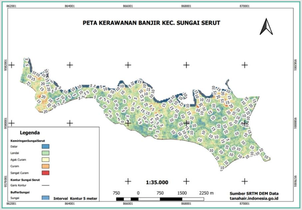
Several areas in Bengkulu City are affected by floods every year; one of the worst is the Sungai Serut sub-district. The existence of a river that stretches along Sungai Serut also plays a role in floods over the Bengkulu area. Furthermore, this study to see the priority area over this district is still limited. Mapping flood areas is one way to provide information, especially for decision-makers in flood control using geographic information systems. Our research aims to map flood vulnerability areas based on land height, slope, and river buffer by weighting these criteria. This thematic map is the result of overlaying several maps according to the flood vulnerability criteria. The results of this study indicate that Sungai Serut is an area with "Very Vulnerable" and "Vulnerable" levels of flood vulnerability. The story of flood vulnerability is dominated by gently sloping contours, with land elevation levels mostly below 20 m above sea level. In addition, the thing that exacerbates the potential for flood vulnerability is the existence of the river that runs along the Sungai Serut sub-district.
Downloads
References
L. Z. Mase, “Slope Stability and Erosion-Sedimentation Analyses Along Sub-watershed of Muara Bangkahulu River in Bengkulu City, Indonesia,” E3S Web Conf., vol. 148, 2020.
E. Ernawati, V. Arie, B. Andara, and R. Regen, "Web-GIS mapping for watershed and land cover area in Bengkulu," Sustinere J. Environ. Sustain., vol. 3, no. 3, 2019.
P. M. Mather and M. Koch, "Environmental Geographical Information Systems: A Remote Sensing Perspective," in Computer Processing of Remotely-Sensed Images, John Wiley & Sons, Ltd, 2011, pp. 325–375.
G. Himbawan, “Penyebab Tetap Bermukimnya Masyarakat di Kawasan Rawan Banjir Kelurahan Tanjung Agung Kota Bengkulu.” UNIVERSITAS DIPONEGORO, 2010.
I. U. Sikder, "Knowledge-based spatial decision support systems: An assessment of environmental adaptability of crops," Expert Syst. Appl., vol. 36, no. 3 PART 1, pp. 5341–5347, 2009.
H. Hamdani, S. Permana, and A. Susetyaningsih, “Analisa daerah rawan banjir menggunakan aplikasi sistem informasi geografis (studi kasus pulau bangka),” J. Konstr., vol. 12, no. 1, 2014.
F. W. Adininggar, A. Suprayogi, and A. P. Wijaya, “Pembuatan Peta Potensi Lahan Berdasarkan Kondisi Fisik Lahan Menggunakan Metode Weighted Overlay,” J. Geod. Undip, vol. 5, no. 2, pp. 136–146, 2016.
A. Lima et al., "Land use and land cover changes determine the spatial relationship between fire and deforestation in the Brazilian Amazon," Appl. Geogr., vol. 34, pp. 239–246, 2012.
N. Tsutsumida and A. J. Comber, "Measures of spatio-temporal accuracy for time series land cover data," Int. J. Appl. Earth Obs. Geoinf., vol. 41, pp. 46–55, 2015.
W. Komputer, Pemodelan SIG untuk Mitigasi Bencana. Elex Media Komputindo, 2015.
T. P. E. Pratama, W. P. Prihadita, V. P. Yuliatama, S. P. Ramadhani, W. Safitri, and H. N. Syifa, “Analisis Index Overlay Untuk Pemetaan Kawasan Berpotensi Banjir di Gowa, Provinsi Sulawesi Selatan,” J. Geosains dan Remote Sens., vol. 1, no. 1, pp. 52–64, 2020.
A. Putra, A. T. Ratnaningsih, and M. Ikhwan, “Pemetaan Daerah Rawan Kebakaran Hutan dan Lahan dengan Menggunakan SIstem Informasi Geografis (Studi Kasus: Kecamatan Bukit Batu, Kab. Bengkalis),” Wahana For. J. Kehutan., vol. 13, no. 1, pp. 55–63, 2018.
E. Suherlan, “Zonasi Tingkat Kerentanan Banjir Kabupaten Bandung Menggunakan Sistim Informasi Geografis,” Skripsi Fak. MIPA Inst. Pertan. Bogor, 2001.
F. Angriani and R. Kumalawati, “Pemetaan Bahaya Banjir Kabupaten Hulu Sungai Tengah Provinsi Kalimantan Selatan,” J. Spat. Wahana Komun. dan Inf. Geogr., vol. 16, no. 2, pp. 21–26, 2016.
M. Sholahuddin, “SIG Untuk Memetakan Daerah Banjir Dengan Metode Skoring Dan Pembobotan (Studi Kasus Kabupaten Jepara),” Jepara: Udinus, 2014.
Downloads
Published
How to Cite
Issue
Section
License
This is an open access journal which means that all content is freely available without charge to the user or his/her institution. The copyright in the text of individual articles (including research articles, opinion articles, and abstracts) is the property of their respective authors, subject to a Creative Commons CC-BY-SA licence granted to all others. ITJRD allows the author(s) to hold the copyright without restrictions and allows the author to retain publishing rights without restrictions.


