
The Comparison of Vector and Raster Data for The Calculation of Landscape Environment Using a Geographic Information System Approach
DOI:
https://doi.org/10.25299/itjrd.2023.10878Keywords:
Comparison, Multi-resolution, GIS ApproachAbstract
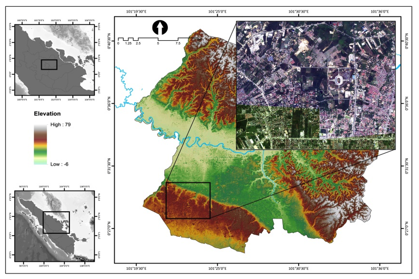
GIS-based measurements can combine vector and raster data to produce thematic data obtained from remote sensing data. The data used in this study uses data on land use in the city of Pekanbaru. After the data is obtained, the pixel calculation process is carried out using three methods: the cell center method, the maximum area, and the maximum combined area. This data describes information with multiple raster data resolutions and then interprets the level of distortion in the data. The research findings found that in the process of raster data from 8 different resolution levels for the 5x5 meter category, it is able to provide results that are closest to the area of vector data, where PL 1 code produces 404229 pixels, PL 2 code ranges from 225717 pixels, PL 3 code ranges from 160323 pixels, code PL 4 ranges from 92268 pixels, PL 5 code reaches 73384 pixels, PL 6 code reaches 57237 pixels, and PL 7 code reaches 48315 pixels. Meanwhile, of the 3 methods that were compared to determine distortion with vector data, the cell center approach was the closest to raster data by calculation through eight levels of raster resolution compared to the other two methods. In choosing the right pixel resolution for further use in mathematical modeling, it is necessary to pay attention to the level of resolution by generalizing the resolution of satellite imagery data so that the data can have the same resolution. The weakness of the three methods lies in increasing the resolution the greater it will make the data coarser. This research is expected to be used as a consideration in future research to add a more precise process and be able to produce less storage capacity.
Downloads
References
S. Khan and K. Mohiuddin, “Evaluating the parameters of ArcGIS and QGIS for GIS Applications Related papers,” Int. J. Adv. Res. Sci. Eng., vol. 7, no. 3, pp. 582–594, 2018.
A. Rosca, I. Juca, O. Timbota, V. Belin, R. Bertici, and M. V Herbei, “Methods for Digitalizing Information from Analogic Support and Creating Databases,” Res. J. Agric. Sci., vol. 52, no. 4, pp. 104–112, 2020, [Online]. Available: https://www.esri.com/news/arcnews/fall07articles/fall07gifs/p3p6-lg.jpg.
A. Amura, A. Aldini, S. Pagnotta, E. Salerno, A. Tonazzini, and P. Triolo, “Analysis of diagnostic images of artworks and feature extraction: Design of a methodology,” J. Imaging, vol. 7, no. 3, 2021, doi: 10.3390/jimaging7030053.
P. Bettinger, G. A. Bradshaw, and G. W. Weaver, “Effects of geographic information system vector-raster-vector data conversion on landscape indices,” Can. J. For. Res., vol. 26, pp. 1416–1425, 1996.
B. Hofer, E. Papadakis, and S. Mäs, “Coupling knowledge with GIS operations: The benefits of extended operation descriptions,” ISPRS Int. J. Geo-Information, vol. 6, no. 2, 2017, doi: 10.3390/ijgi6020040.
B. M. Meneses, E. Reis, R. Reis, and M. J. Vale, “The effects of land use and land cover geoinformation raster generalization in the analysis of LUCC in Portugal,” ISPRS Int. J. Geo-Information, vol. 7, no. 10, pp. 1–21, 2018, doi: 10.3390/ijgi7100390.
T. G. Wade, J. D. Wickham, M. S. Nash, A. C. Neale, K. H. Riitters, and K. B. Jones, “A Comparison of Vector and Raster GIS Methods for Calculating Landscape Metrics Used in Environmental Assessments,” Photogramm. Eng. Remote Sensing, vol. 69, no. 2, pp. 1399–1405, 2003, doi: 10.14358/PERS.69.12.1399.
M. A. Rahman et al., “Development of GIS Database for Infrastructure Management: Power Distribution Network System,” IOP Conf. Ser. Earth Environ. Sci., vol. 540, no. 1, 2020, doi: 10.1088/1755-1315/540/1/012067.
H. Wang, “A Large-scale Dynamic Vector and Raster Data Visualization Geographic Information System Based on Parallel Map Tiling,” 2011.
B. Peter and R. Weibel, “Using Vector and Raster-Based Techniques in Categorical Map Generalization Framework for Categorical Map Generalization,” in Third ICA Workshop on Progress in Automated Map Generalization, 1999, pp. 1–14.
M. Li, H. McGrath, and E. Stefanakis, “Multi-resolution topographic analysis in hexagonal Discrete Global Grid Systems,” Int. J. Appl. Earth Obs. Geoinf., vol. 113, no. August, p. 102985, 2022, doi: 10.1016/j.jag.2022.102985.
R. G. Cromley and D. M. Hanink, “Coupling land use allocation models with raster GIS,” J. Geogr. Syst., vol. 1, pp. 137–153, 1999.
G. A. Kiyashko, “Application of GIS Technology for Town Planning Tasks Solving,” in IOP Conference Series: Materials Science and Engineering, 2017, vol. 262, no. 1, doi: 10.1088/1757-899X/262/1/012112.
Y. S. Huang et al., “Vector and Raster Data Layered Fusion and 3D Visualization,” Int. Arch. Photogramm. Remote Sens. Spat. Inf. Sci., vol. 42, pp. 1127–1134, 2020, doi: 10.5194/isprs-archives-XLII-3-W10-1127-2020.
T. Cheng, Z. Gao, G. Li, X. Zheng, and J. Yang, “Extracting Land Cover Change Information by using Raster Image and Vector Data Synergy Processing Methods,” 2015, doi: 10.2991/jimet-15.2015.33.
M. Porczek, D. Rucinska, and S. Lewinski, “Using raster and vector data to identify objects for classify in flood risk . A case study : Raciborz,” in XVIIth Conference of PhD Students and Young Scientists, 2018, vol. 29, pp. 1–13.
S. Winter and A. U. Frank, “Topology in Raster and Vector Representation,” Geoinformatica, vol. 4, no. 1, pp. 35–65, 2000.
A. Courtial, G. Touya, and X. Zhang, “Representing Vector Geographic Information As a Tensor for Deep Learning Based Map Generalisation,” Agil. GIScience Ser., vol. 3, no. 32, pp. 1–8, 2022, doi: 10.5194/agile-giss-3-32-2022.
S. Ladra, J. R. Lo, and F. S. Id, “Efficient processing of raster and vector data,” PLoS One, vol. 15, no. 1, pp. 1–35, 2020, doi: 10.1371/journal.pone.0226943.
D. Buil-gil and S. H. Langton, GIS and Geovisual Analysis. SAGE Publications Ltd, 2020.
J. M. Piwowar and E. F. Ledrew, “Integrating Spatial Data: A User’s Perspective,” Photogramm. Eng. Remote Sensing, vol. 56, no. 11, pp. 1497–1502, 1990.
G. A. Plumb, “Compression of continuous spatial data in the raster digital format,” Comput. Geosci., vol. 19, no. 4, pp. 493–497, 1993.
I. W. Sandi, A. Rahman, P. Penelitian, L. Hidup, P. Universitas, and P. B. Jln, “Application of Geographic Information System ( GIS ) based raster data to classify land capability in Bali Province by using differentiator pixel value method,” J. Mns. dan Lingkung., vol. 19, no. 1, pp. 21–29, 2012.
BPS, “Hasil Sensus Penduduk 2020 Kota Pekanbaru,” 2021.
ESRI, “How Polygon To Raster works,” 2022.
J. O’Rourke, Computational Geometry in C. New York: Cambridge University Press, 1994.
P. Xie, Y. Liu, Q. He, X. Zhao, and J. Yang, “An efficient vector-raster overlay algorithm for high-accuracy and high-efficiency surface area calculations of irregularly shaped land use patches,” ISPRS Int. J. Geo-Information, vol. 6, no. 6, 2017, doi: 10.3390/ijgi6060156.
P. L. Delamater, J. P. Messina, A. M. Shortridge, and S. C. Grady, “Measuring geographic access to health care : raster and network-based methods,” Int. J. ofHealth Geogr., vol. 11, no. 15, pp. 1–18, 2012.
R. C. Herbei, M. V. Herbei, A. Matei, and E. C. Dunca, “Spatial analysis methods of raster data used into the geographical information systems,” J. Polish Miner. Eng. Soc., vol. 19, no. 1, pp. 151–158, 2018, doi: 10.29227/IM-2018-01-25.
E. Agosto, “Vector – raster server-side analysis : a PostGIS benchmark,” Appl Geomat, vol. 5, pp. 177–184, 2013, doi: 10.1007/s12518-013-0104-x.
G. Farkas, “Possibilities of using raster data in client-side web maps,” Trans. GIS, vol. 24, no. 1, pp. 72–84, 2020, doi: 10.1111/tgis.12588.
J. Nowosad and T. F. Stepinski, “Extended SLIC superpixels algorithm for applications to non-imagery geospatial rasters,” Int. J. Appl. Earth Obs. Geoinf., vol. 112, no. June, p. 102935, 2022, doi: 10.1016/j.jag.2022.102935.
Downloads
Published
How to Cite
Issue
Section
License
This is an open access journal which means that all content is freely available without charge to the user or his/her institution. The copyright in the text of individual articles (including research articles, opinion articles, and abstracts) is the property of their respective authors, subject to a Creative Commons CC-BY-SA licence granted to all others. ITJRD allows the author(s) to hold the copyright without restrictions and allows the author to retain publishing rights without restrictions.


