
Geoelectricity Data Analysis For Identification The Aquifer Configuration In Bandorasawetan, Cilimus, Kuningan, West Java Province
DOI:
https://doi.org/10.24273/jgeet.2017.2.4.779Keywords:
Mt. Ceremai, Bandorasawetan, geoelectric, ground water, aquiferAbstract
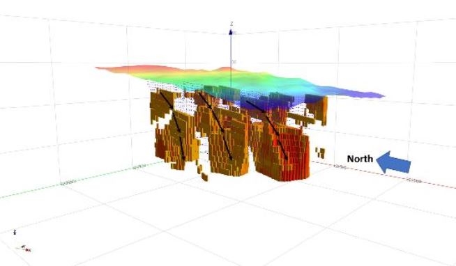
Indonesian water consumption is influenced by the people growth. One of Water consumption fulfilment by groundwater aquifer. Bandorasawetan is one of the areas which predicted have proper potential due to located in East of Mt. Ceremai that predicted recharge area. Based on regional geological data, Bandorasawetan is an undifferentiated young volcanic product which consists of lava, breccia, lapilli, and tuffaceous sand. Geophysics method for groundwater prediction is 2-D geoelectrical with Wenner – Schlumberger configuration. The result of acquisition is obtained resistivity value from 0 - >1000 Ohm. m. Interpretation from data distribution is consist of two resistivity range that describes lithology on the research area, such as: 0 – 150 Ohm.m contributed as aquiqlud with tuffaceous sand lithology and > 150 Ohm.m interpreted as volcanic breccia lithology. Volcanic breccia has a role as aquifer in study area, the conclusion is distribution of resistivity value with range > 150 Ohm.m be the reference to developing groundwater resource in study area. Depth of aquifer is varying, deeper to the east. In Line – 1, depth of the aquifer is 48 meters and in Line – 2, depth of aquifer be 60 meters.
Downloads
References
Heiken, G. & Wohletz, K. 1992. Volcanology and Geothermal Energy. University of California Press. Barkeley, Los Angeles, Oxford.
Loke, M.H., 2000, Electrical imaging surveys for environmental and engineering studies; A practical guide to 2-D and 3-D surveys, www.geoelectrical.com.
Loke, M.H., 2004, COURSENOTES: 2-D and 3-D electrical imaging surveys, www.geoelectrical.com.
Reynold, J.M., 1998, An Introduction to applied and environmental geophysics, John Wiley and sons Inc, New York, p.415.
Santoso, Djoko., 2002., Pengantar Teknik Geofisika., Departemen Teknik Geofisika., Fakultas Ilmu dan Teknologi Mineral., Institut Teknologi Bandung.
Telford, W.M., Geldart, L.P., Sheriff R.E, 1990, Applied Geophysics, 2nd Edition, Cambridge University Press, p.522.
Downloads
Published
Issue
Section
License
Copyright @2019. This is an open-access article distributed under the terms of the Creative Commons Attribution-ShareAlike 4.0 International License which permits unrestricted use, distribution, and reproduction in any medium. Copyrights of all materials published in JGEET are freely available without charge to users or / institution. Users are allowed to read, download, copy, distribute, search, or link to full-text articles in this journal without asking by giving appropriate credit, provide a link to the license, and indicate if changes were made. All of the remix, transform, or build upon the material must distribute the contributions under the same license as the original.


