
Analisis Keruntuhan Bendungan Akibat Piping dan Pemetaan Genangan Banjir (Studi Kasus : Bendungan Saguling)
Dam Break Analysis Due To Piping And Flood Mapping (Case Study Of Saguling DAM)
DOI:
https://doi.org/10.25299/saintis.2022.vol22(01).8081Keywords:
Kegagalan Bendungan, Rencana Tindak Darurat, Peta Genangan Banjir, Analisis Keruntuhan Bendungan, PipingAbstract
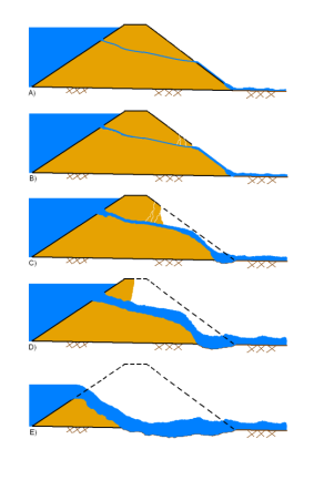
[ID] Salah satu upaya penanggulangan kegagalan bendungan adalah penyusunan Rencana Tindak Darurat. Rencana tindak darurat memuat peta genangan banjir akibat keruntuhan. Peta genangan banjir merupakan aspek penting karena menjadi dasar dalam pengambilan keputusan penanggulanan kegagalan bendungan. Peta genangan banjir diperoleh dari analisis keruntuhan bendungan. Penelitian ini melakukan analisis keruntuhan bendungan Bendungan Saguling yang merupakan bendungan kaskade di Wilayah Sungai Citarum. Analisis keruntuhan dalam penelitian ini terdiri analisis hidrograf keruntuhan menggunakan HEC-HMS, penelusuran banjir menggunakan HEC-RAS, dan pengolahan informasi spasial menggunakan QuantumGIS. Skenario keruntuhan bendungan yang dimodelkan adalah keruntuhan akibat piping saat sunnyday dengan variasi initial piping pada 1/3 ketinggian, ½ ketinggian dan 2/3 ketinggian bendungan. Hasil analisis hidrograf keruntuhan dari ketiga skenario tersebut cenderung mirip dengan debit puncak keruntuhan sebesar 61193,6 m3/dt. Keruntuhan Bendungan Saguling mengakibatkan Bendungan Cirata mengalami overtopping. Sedangkan Bendungan Jatiluhur tidak mengalami overtopping apabila Bendungan Cirata tidak mengalami keruntuhan. Peta genangan banjir akibat keruntuhan Bendungan Saguling pada ketiga skenario cenderung mirip. Jumlah desa terdampak dengan jarak dari Bendungan Saguling kurang dari 10 km sebanyak 6 desa daro 10 desa. Desa Baranangsiang dan Desa Saguling adalah desa pertama yang terdampak banjir akibat keruntuhan Bendungan Saguling dengan estimasi waktu kedatangan banjir ± 0,25 jam semenjak dimulai keruntuhan
[EN] One of the efforts to overcome dam failure is preparing an Emergency Action Plan. The emergency action plan contains a map of the flood inundation due to the collapse. The flood inundation map is essential because it becomes the basis for making dam failure management decisions. The flood inundation map was obtained from the dam break analysis. This study analyzes the Saguling Dam collapse, a cascade dam in the Citarum River Basin. The failure analysis in this study consisted of collapse hydrograph analysis using HEC-HMS, flood routing using HEC-RAS, and processing of spatial information using QuantumGIS. The dam failure scenario modelled is due to piping on sunny days with initial piping variations at 1/3 height, height and 2/3 height of the dam. The results of the failure hydrograph analysis of the three scenarios tend to be similar to the failure peak discharge of 61193.6 m3/s. The collapse of the Saguling Dam caused the Cirata Dam to be overtopped. Meanwhile, Jatiluhur Dam does not experience overtopping if the Cirata Dam does not collapse. The flood inundation maps due to the collapse of the Saguling Dam in the three scenarios tend to be similar. The number of affected villages less than 10 km from the Saguling Dam is six out of 10 villages. Baranangsiang Village and Saguling Village are the first villages affected by flooding due to the collapse of the Saguling Dam, with an estimated flood arrival time of ± 0.25 hours since the collapse started.
Downloads
References
KemenPUPR, PermenPUPR No 27 2015 tentang Bendungan. Jakarta: Kementerian PUPR, 2015. [Online]. Available: https://jdih.pu.go.id/internal/assets/assets/produk/PermenPUPR/2015/05/PermenPUPR27-2015.pdf
B. G. Look, Handbook of Geotechnical Investigation and Design Tables. The Netherlands: Taylor & Francis, 2007. doi: 10.1201/9780203946602.
R. Fell, P. MacGregor, D. Stapledon, and G. Bell, Geotechnical Engineering of Dams. 2015. doi: 10.1201/noe0415364409.
K. M. Murdiani, S. Sangkawati, and K. W. Sadono, “Pemodelan Keruntuhan Bendungan Menggunakan HEC-RAS 2D Studi Kasus Bendungan Gondang, Kabupaten Karanganyar,” Rekayasa, vol. 13, no. 2, 2020, doi: 10.21107/rekayasa.v13i2.6872.
FERC, FERC Engineering Guidelines Risk-Informed Decision Making Chapter R21 Dam Breach Analysis. Washington, D,C, 2014. [Online]. Available: https://www.ferc.gov/sites/default/files/2020-04/chapter-R21.pdf
M. Arifin and M. A. Budiyanto, “Analisis Keruntuhan Bendungan (Dam Break Analysis) dalam Upaya Mitigasi Bencana (Studi Kasus di Waduk/ Bendungan Tempuran),” CivETech, vol. 14, no. 2, 2019, doi: 10.47200/civetech.v14i2.707.
M. A. F. Khairi, H. Suprijanto, and A. P. Hendrawan, “Analisis Keruntuhan Bendungan Rukoh Kabupaten Pidie Menggunakan Aplikasi HEC-RAS dan Berbasis InaSAFE,” JTRESDA, vol. 2, no. 1, pp. 055–066, 2022, doi: https://doi.org/10.21776/ub.jtresda.
F. R. Pramana, P. T. Juwono, and R. Asmaranto, “Analisa Keruntuhan Bendungan Kering Ciawi Menggunakan Program HEC-RAS dan InaSAFE,” J. Teknol. dan Rekayasa Sumber Daya Air, vol. 1, no. 2, pp. 524–534, Jul. 2021, doi: 10.21776/ub.jtresda.2021.001.02.16.
M. B. Ansori, A. A. N. S. Damarnegara, N. F. Margini, and D. A. D. Nusantara, “Flood Inundation And Dam Break Analysis For Disaster Risk Mitigation (A Case Study Of Way Apu Dam),” Int. J. GEOMATE, vol. 21, no. 84, 2021, doi: 10.21660/2021.84.j2130.
P. I. Purwanto, P. T. Juwono, and R. Asmaranto, “Analisa Keruntuhan Bendungan Tugu Kabupaten Trenggalek,” J. Tek. Pengair., vol. 8, no. 2, pp. 222–230, Nov. 2017, doi: 10.21776/ub.pengairan.2017.008.02.8.
S. Siswanto, S. Suprapto, and A. L. Huda, “Pendekatan GIS dalam Pemodelan Keruntuhan Bendungan Menggunakan HEC-RAS 2D (Studi Kasus Bendungan Logung, Kabupaten Kudus),” Rekayasa, vol. 12, no. 2, pp. 112–119, Oct. 2019, doi: 10.21107/rekayasa.v12i2.5807.
P. Wijayanti, M. Suprapto, and A. P. Saido, “Analisis Keruntuhan Bendungan Pacal,” Matriks Tek. Sipil, vol. 1 No.4 / D, no. 4, 2013, doi: https://doi.org/10.20961/mateksi.v1i4.37505.
D. Wirustyastuko and J. Nugroho, “Analisis Wilayah Tergenang dan Perilaku Banjir pada Simulasi Kegagalan Bendungan Ciawi,” J. Tek. Sipil, vol. 20, no. 2, p. 121, Aug. 2013, doi: 10.5614/jts.2013.20.2.5.
K. E. Milleanisa, R. Asmaranto, and P. T. Juwono, “Analisa Keruntuhan Bendungan Gembong di Kabupaten Pati Dengan Menggunakan Program Zhong Xing HY21,” J. Teknol. dan Rekayasa Sumber Daya Air, vol. 1, no. 2, pp. 864–875, Jul. 2021, doi: 10.21776/ub.jtresda.2021.001.02.43.
A. Murdhianti, P. T. Juwono, and R. Asmaranto, “Mitigasi Bencana Banjir Akibat Keruntuhan Bendungan Berdasarkan Dambreak Analysis Pada Bendungan Benel di Kabupaten Jembrana,” J. Tek. Pengair., vol. 7, no. 2, 2016, [Online]. Available: https://www.jurnalpengairan.ub.ac.id/index.php/jtp/article/view/295
PT. Kwarsa Hexagon, “Kajian Inspeksi Besar Bendungan Saguling - Laporan Utama,” Bandung, 2017.
N. Iriawan and J. S. I. Hanugraheni, “Pemodelan Bayesian Hirarki Data Curah Hujan Ekstrem di Jakarta,” J. Sains dan Seni ITS, vol. 5, no. 1, 2016, doi: 10.12962/j23373520.v5i1.14378.
USACE, “HEC-RAS, River Analysis System Hydraulic Reference Manual,” 2021. [Online]. Available: https://www.hec.usace.army.mil/software/hec-ras/documentation/HEC-RAS 5.0 Reference Manual.pdf
D. C. Froehlich, “Embankment Dam Breach Parameters and Their Uncertainties,” J. Hydraul. Eng., vol. 134, no. 12, pp. 1708–1721, Dec. 2008, doi: 10.1061/(ASCE)0733-9429(2008)134:12(1708).
M. F. Shahrim and F. C. Ros, “Dam Break Analysis of Temenggor Dam Using HEC-RAS,” IOP Conf. Ser. Earth Environ. Sci., vol. 479, p. 012041, Jul. 2020, doi: 10.1088/1755-1315/479/1/012041.
E. Psomiadis, L. Tomanis, A. Kavvadias, K. X. Soulis, N. Charizopoulos, and S. Michas, “Potential Dam Breach Analysis and Flood Wave Risk Assessment Using HEC-RAS and Remote Sensing Data: A Multicriteria Approach,” Water, vol. 13, no. 3, p. 364, Jan. 2021, doi: 10.3390/w13030364.
A. Urzică et al., “Using 2D HEC-RAS modeling and embankment dam break scenario for assessing the flood control capacity of a multireservoir system (Ne Romania),” Water (Switzerland), vol. 13, no. 1, Jan. 2021, doi: 10.3390/w13010057.
M. G. Tedla, Y. Cho, and K. Jun, “Flood Mapping from Dam Break Due to Peak Inflow: A Coupled Rainfall–Runoff and Hydraulic Models Approach,” Hydrology, vol. 8, no. 2, p. 89, Jun. 2021, doi: 10.3390/hydrology8020089.
USACE, “HEC-HMS Technical Reference Manual,” 2021. https://www.hec.usace.army.mil/confluence/hmsdocs/hmstrm/modeling-reservoirs/dam-break (accessed Jul. 11, 2021).
PT. Kwarsa Hexagon, “Kajian Inspeksi Besar Bendungan Saguling - Laporan Akhir Rencana Tindak Darurat,” Bandung, 2017.
USACE, “River Analysis System HEC-RAS Mapper User ’ s Manual,” 2021. [Online]. Available: https://www.hec.usace.army.mil/confluence/rasdocs/rmum/6.1
I. D. Tisnasuci, A. Sukmono, and F. Hadi, “Analisis Pengaruh Perubahan Tutupan Lahan Daerah Aliran Sungai Bodri Terhadap Debit Puncak Menggunakan Metode Soil Conservation Service (Scs),” J. Geod. Undip, vol. 10, no. 1, 2020.
A. Leoul and N. Kassahun, “Dam Breach Analysis Using HEC-RAS and HEC-GeoRAS: The Case of Kesem Kebena Dam,” Open J. Mod. Hydrol., vol. 09, no. 04, pp. 113–142, 2019, doi: 10.4236/ojmh.2019.94007.
A. Mihu-Pintilie, C. I. Cîmpianu, C. C. Stoleriu, M. N. Pérez, and L. E. Paveluc, “Using High-Density LiDAR Data and 2D Streamflow Hydraulic Modeling to Improve Urban Flood Hazard Maps: A HEC-RAS Multi-Scenario Approach,” Water, vol. 11, no. 9, p. 1832, Sep. 2019, doi: 10.3390/w11091832.
PT. Indra Karya (Persero) Divisi Engineering I, “Inspeksi Besar Bendungan Cirata - Laporan Utama,” Malang, 2020.
FEMA, “Technical Manual: Overtopping Protection for Dams,” 2014. [Online]. Available: https://damfailures.org/wp-content/uploads/2015/06/Technical-Manual_Overtopping-Protection-for-Dams.pdf
BBWS Citarum, “Special Study on JatiluhurDam Safety Improvement and Rehabilitation The Dam Operational Improvement and Safety Project (DOISP) - Technical Report On Downstream Flood Assessment Volume I – Estimation of Floods,” Bandung, 2015.
Downloads
Published
How to Cite
Issue
Section
License

This work is licensed under a Creative Commons Attribution-ShareAlike 4.0 International License.
Copyright. This is an open access article which means that all content is freely available without charge to the user or his/her institution. Jurnal Saintis allows the author(s) to hold the copyright without restriction. The copyright in the text of individual articles (including research articles, opinion articles, and abstracts) is the property of their respective authors distributed under the terms of the Creative Commons Attribution-ShareAlike 4.0 International License which permits unrestricted use, distribution, and reproduction in any medium. Users are allowed to read, download, copy, distribute, search, or link to full-text articles in this journal without asking by giving appropriate credit, provide a link to the license, and indicate if changes were made.