
Indikasi Struktur Patahan Berdasarkan Data Citra Satelit dan Digital Elevation Model (DEM) Sungai Siak, Tualang dan Sekitarnya Sebagai Pertimbangan Pengembangan Pembangunan Wilayah
Indications Fault Structure Based on Satellite Imagery Data and Digital Elevation Model (DEM) River Siak, Tualang Area As Development considerations Regional development
Keywords:
Fault, Satellite Imagery Data, Digital Elevation ModelAbstract
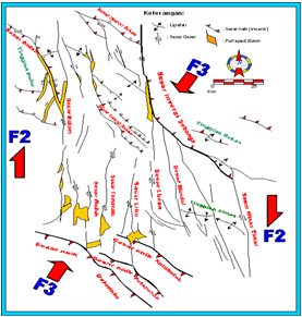
[ID] Struktur patahan dapat ditunjukkan dengan adanya indikasi yang berupa pola kelurusan sungai, adanya offset litologi, dan lainnya. Berdasarkan data citra satelit dan digital elevation model terdapat kemunculan indikasi adanya struktur patahan pada daerah tualang dan sekitarnya. Hal ini terlihat dari kelurusan Sungai Siak. Anomali ini sangat terlihat jelas pada pola aliran sungai yang menujukkan perubahan signifikan pada daerah hulu yang berbentuk meander / berkelok kemudian berubah seketika menjadi bentuk straight/ lurus. Hal ini menunjukkan adanya indikasi struktur patahan. Berdasarkan kenampakan citra satelit terlihat adanya offset perbukitan yang bergeser dengan pergerakan patahan. Hal ini juga didukung dengan data pendukung kerangka tektonik cekungan sumatera tengah yang menandakan adanya fase kompresi selama Oligosen Tengah sampai Miosen Tengah dengan arah tegasan Utara – Selatan dan mengalami reaktivasi pada pliosen – pleistosen. Hal ini diharapkan menjadi perhatian bagi daerah – daerah yang akan dilalui patahan tersebut berkaitan dengan pengembangan pembangunan, karena setiap pergerakan lempeng terjadi bisa mereaktifasi patahan tersebut dan mempengaruhi daerah – daerah disekitarnya.
[EN] The fault structure can be shown by several indication such as pattern of alignment of the river, the offset lithology, and others. Based on data from satellite imagery and digital elevation models there are emergence of indications of faults structure in the Tualang Area and its surroundings, It is seen from the lineament of the Siak river, these anomalies are very clearly shown in the flow pattern of the river that showed significant changes in upstream areas which start from meanders type of channel and then changed instantly into straight shape as an indication of fault structure. Based on feature on satellite image, there are shifting hills by fault movement. This is also supported by a tectonic framework of Central Sumatran Basin, which indicates the compression phase during Middle Oligocene to Middle Miocene with trend towards North - South direction and reactivated in the Pliocene - Pleistocene. It has to be considered for the regional development in the area which will be affected by the fault structure, because every movement of the plates can reactivate the fault and affects the surrounding areas.
Downloads
References
Clarke, M.C.G., Kartawa, A. Djunud-din, A., Suganda, E. Bagdja, M. 1982. Peta Geologi Lembar Pa-kanbaru, Sumatra. Pusat Penelitian dan Pengembangan Geologi. Bandung.
Eubank, R.T., dan Makki A.C., 1981, Structural geology of the Cen-tral Sumatera back-arc basin, Proceeding Indonesian Petro-leum Association, 16th Annual Convention, p. 153-196.
Heidrick, T.L. dan K. Aulia, 1996, A structural and tectonic model of the Coastal Plain Block, Central Sumatra Basin, Proceeding In-donesian Petroleum Association, 22nd Annual Convention, p. 285 – 303.
Indarto, Yohanes B.C. 2014. Fault-Seal Analysis in Minas Field Area-1, Central Sumatra Basin. Proceeding Indonesian Petro-leum Association, 39th Annual Convention.
Mertosono, S. dan Nayoan G.A.S. (1974): The Tertiary Basinal Area Of Central Sumatra. Pro-ceedings IPA 3rd Annual Con-vention, 63-76.
Prawirodirdjo, L., dan Bock, Y.2004. Instantaneous global plate mo-tion model from 12 years of continuous GPS observations. Journal of Geophysical Re-search Atmospheres vol. 109, 1-15.
Pulunggono, A. dan Cameron, N.R. (1984): Sumatran microplates, their characteristics and their role in the evolution of The Central and South Sumatra Ba-sins, Proceedings IPA 13th An-nual Convention, 121-143.
Yarmanto dan Aulia, K. (1998): The seismic expression of wrench tectonic Central Sumatra Basin, IAGI, Jakarta, 86-94.
Downloads
Published
How to Cite
Issue
Section
License
Copyright (c) 2016 Tiggi Choanji

This work is licensed under a Creative Commons Attribution-ShareAlike 4.0 International License.

This work is licensed under a Creative Commons Attribution-ShareAlike 4.0 International License.
Copyright. This is an open access article which means that all content is freely available without charge to the user or his/her institution. Jurnal Saintis allows the author(s) to hold the copyright without restriction. The copyright in the text of individual articles (including research articles, opinion articles, and abstracts) is the property of their respective authors distributed under the terms of the Creative Commons Attribution-ShareAlike 4.0 International License which permits unrestricted use, distribution, and reproduction in any medium. Users are allowed to read, download, copy, distribute, search, or link to full-text articles in this journal without asking by giving appropriate credit, provide a link to the license, and indicate if changes were made.