
Pemetaan Daerah Rawan Ancaman Banjir di Area Kabupaten Kampar Dengan Menggunakan GEE (Google Earth Engine)
Analysis of Flood Inundation Areas In Kabupaten Kampar Using GEE (Google Earth Engine)
DOI:
https://doi.org/10.25299/saintis.2024.vol24(01).15487Keywords:
Banjir, Spatio-Temporal, Kabupaten Kampar, Climate Hazards InfraRed Precipitation with Station (CHIRPS), Google Earth Engine (GEE)Abstract
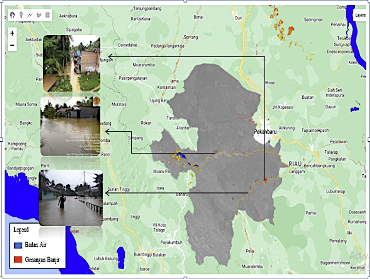
[ID] Kabupaten Kampar merupakan salah satu wilayah yang sering mengalami banjir, yang diakibatkan meluapnya sungai Kampar. Sepanjang tahun 2011 – 2017 tercatat paling sedikit telah terjadi bencana banjir 1 (satu) kali dalam setahun. Untuk meminimalisir dampak kejadian banjir, maka perlu dilakukan mempelajari karakteristik curah hujan secara temporal maupun spasial. Hal ini penting sebagai informasi kepada masyarakat untuk mengantisipasi dampak curah hujan ekstrim pada waktu dan lokasi tertentu. Penelitian ini bertujuan untuk mengindentifikasi spatio-temporal yang ekstrim dari curah hujan di Kabupaten Kampar yang sering menyebabkan banjir. Namun untuk mengidentifikasi ciri – ciri hujan, penelitian ini menggunakan CHIRPS (Climate Hazards InfraRed Precipitation dengan Station) data satelit karena data observasi data curah hujan di Station Klimatologi Riau tidak tersedia 2012. Hasil identifikasi menunjukan bahwa korelasi ( R ) nilai antara data observasi curah hujan dan data satelit CHIRPS adalah 0.526. Nilai ini adalah diartikan “sedang” untuk dijadikan alternatif data kajian. GEE (Google Earth Engine) sebagai platform berbasis cloud digunakan untuk mengidentifikasi karakteristik temporal diketahui curah hujan ekstrim terjadi di bulan Januari, Juni, Agustus dan November. Hasil identifikasi spasial menunjukan bahwa wilayah tersebut mempunyai rata – rata curah hujan maksimum tertinggi terdapat di wilayah Kecamatan Koto Kampar Hulu 40.01 mm/hari. Ini dapat dipastikan dengan melihat dokumentasi kejadian banjir yang sering terjadi di wilayah tersebut.
[EN] Kampar Regency is one of the areas that frequently experiences flooding, which is caused by the overflowing of the Kampar River. Throughout 2011 - 2017, it was recorded that at least 1 (one) flood disaster occurred a year. To minimize the impact of flood events, it is necessary to study the characteristics of rainfall both temporally and spatially. This is important as information for the public to anticipate the impact of extreme rainfall at certain times and locations. This research aims to identify spatio-temporal extremes of rainfall in Kampar Regency which often cause flooding. However, to identify the characteristics of rainfall, this research uses CHIRPS (Climate Hazards InfraRed Precipitation with Station) satellite data because rainfall observation data at the Riau Climatology Station is not available in 2012. The identification results show that the correlation (R) value between rainfall observation data and CHIRPS satellite data is 0.526. This value is interpreted as "medium" to be used as an alternative study data. GEE (Google Earth Engine) as a cloud-based platform is used to identify the known temporal characteristics of extreme rainfall occurring in January, June, August and November. The spatial identification results show that this area has the highest average maximum rainfall in the Koto Kampar Hulu District area of 40.01 mm/day. This can be confirmed by looking at the documentation of flood events that often occur in the area.
Downloads
References
BPBD Riau. (2022). Dokumen Kajian Resiko Bencana Provinsi Riau. Kab. Kampar: BPBD Provinsi Riau.
Kharisma Dewi Dian, (2022). PEMETAAN KAWASAN RAWAN BANJIR DI KOTA TANJUNGPINANG MENGGUNAKAN GEE (GOOGLE EARTH ENGINE)
Downloads
Published
How to Cite
Issue
Section
License
Copyright (c) 2024 Deni Pratama Deni, Dr. Eng. Sigit Sutikno, ST., MT, Dr. Muhamad Yusa, ST., Msc

This work is licensed under a Creative Commons Attribution-ShareAlike 4.0 International License.

This work is licensed under a Creative Commons Attribution-ShareAlike 4.0 International License.
Copyright. This is an open access article which means that all content is freely available without charge to the user or his/her institution. Jurnal Saintis allows the author(s) to hold the copyright without restriction. The copyright in the text of individual articles (including research articles, opinion articles, and abstracts) is the property of their respective authors distributed under the terms of the Creative Commons Attribution-ShareAlike 4.0 International License which permits unrestricted use, distribution, and reproduction in any medium. Users are allowed to read, download, copy, distribute, search, or link to full-text articles in this journal without asking by giving appropriate credit, provide a link to the license, and indicate if changes were made.