Remote Sensing–Driven Drought Assessment Using Temperature Vegetation Dryness Index (TVDI) Derived from Landsat 8 Imagery
DOI:
https://doi.org/10.25299/jgeet.2026.11.3.27329Keywords:
remote sensing, LST, NDVI, TVDI, Landsat 8Abstract
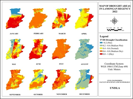
Drought, a persistent state of water scarcity, is a critical challenge for agriculture and resource management. This study examines drought variability in Lamongan Regency from 2021 to 2023 using the Temperature Vegetation Dryness Index (TVDI) derived from Landsat 8 imagery, integrating Land Surface Temperature (LST) and NDVI to classify conditions from wet to dry. Results show the largest moderate drought in June 2021 (1,660.39 km²) and the most extensive severe drought in October 2023 (1,561.39 km²). In 2023, wet-normal conditions dominated early months, while dry areas expanded in the peak dry season. In this study, TVDI was derived using a simplified global normalization of LSTmin and LSTmax rather than the standard pixel-by-pixel NDVI-LST triangular feature space, which is acknowledged as a methodological limitation. An anomaly occurred in February, where high rainfall coincided with widespread dryness. Furthermore, validation with rainfall data showed a very weak correlation (R2 =0.090). This low correlation indicates a distinct time lag between precipitation events and soil moisture response, as well as the strong influence of local evapotranspiration and soil water retention capacity rather than rainfall alone. This study demonstrates that while TVDI is useful for rapid drought mapping, integration with local hydrological parameters is essential for improved accuracy.
Downloads
References
Affandy, N. A., Iranata, D., Anwar, N., Maulana, M. A., Prastyo, D. D., Jaelani, L. M., & Suryadi, F. X. (2023). Modelling causality between agricultural and meteorological drought indices in the Corong River basin, East Java Indonesia. Journal of Water and Land Development, 178–188.
Affandy, N. A., Iranata, D., Anwar, N., Maulana, M. A., Prastyo, D. D., Wardoyo, W., & Sukojo, B. M. (2024). Assessment of Agricultural Drought Using the Normalized Difference Drought Index (NDDI) to Prediction Drought at Corong River Basin. International Journal of Integrated Engineering, 16(1).
Affandy, N. A., Wijaya, B. R., & Nabilah, S. (2024). Pemantauan Dampak Kekeringan Lahan Pertanian di Lamongan Menggunakan NDVI Berbasis SIG. Nucleus Journal, 3(2), 57–67.
Afriadi, A., Septio, G., Chidmahdjati, A. B., & Saputri, D. R. (2026). Correlation Between Land Cover Change and the Spatial Distribution of Land Surface Temperature in Tanjungpinang City, Indonesia. Journal of Geoscience, Engineering, Environment, and Technology, 11(1), 140–153.
Ali, S., Henchiri, M., Yao, F., & Zhang, J. (2019). Analysis of vegetation dynamics, drought in relation with climate over South Asia from 1990 to 2011. Environmental Science and Pollution Research, 26(11), 11470–11481.
Bento, V. A., Trigo, I. F., Gouveia, C. M., & DaCamara, C. C. (2018). Contribution of Land Surface Temperature (TCI) to Vegetation Health Index: A Comparative Study Using Clear Sky and All-Weather Climate Data Records. Remote Sensing, 10(9), 1324.
Chu, H.-J., Wijayanti, R. F., Jaelani, L. M., & Tsai, H.-P. (2021). Time Varying Spatial Downscaling of Satellite-Based Drought Index. Remote Sensing, 13(18), 3693.
Cook, B. I., Miller, R. L., & Seager, R. (2009). Amplification of the North American “Dust Bowl” drought through human-induced land degradation. Proceedings of the National Academy of Sciences, 106(13), 4997–5001.
Hanum, C. M., Kamal, A., Metananda, A. A., Kurniawati, Kiswayadi, D., & Bakruddin. (2026). Spatiotemporal Dynamics of Mangrove Cover in Aceh Tamiang Regency, Indonesia (2020–2024): An NDVI-Based Remote Sensing Assessment. Journal of Geoscience, Engineering, Environment, and Technology, 11(1), 165–171.
Fariz, T. R., Naufal, M. A., Heriyanti, A. P., Eralita, N., & Saputri, L. H. (2025). Exploratory of Ecological Quality from Remote-Sensing Ecological Index and Drought Hazard in Pekalongan Regency, Indonesia. Journal of Geoscience, Engineering, Environment, and Technology, 10(3), 275–281.
Han, X., Chen, X., & Feng, L. (2015). Four decades of winter wetland changes in Poyang Lake based on Landsat observations between 1973 and 2013. Remote Sensing of Environment, 156, 426–437.
Hariyanto, T., Pribadi, C. B., Purwitasari, A., & Kurniawan, A. (2019). Identification of potential drought in Lamongan Regency. IOP Conference Series: Earth and Environmental Science, 389(1), 012009.
Heim, R. R. (2002). A Review of Twentieth-Century Drought Indices Used in the United States. Bulletin of the American Meteorological Society, 83(8), 1149–1166.
Irawan, S., Fitriania, T., Sari, L. R., Natali, S. D., Aji, S. B., & Sismanto. (2024). Drought Management in Batam using Combined NDVI-TCT Algorithm to Create a Classification Level Map. Journal of Geoscience, Engineering, Environment, and Technology, 9(3), 294–300.
Jiao, W., Zhang, L., Chang, Q., Fu, D., Cen, Y., & Tong, Q. (2016). Evaluating an Enhanced Vegetation Condition Index (VCI) Based on VIUPD for Drought Monitoring in the Continental United States. Remote Sensing, 8(3), 224.
Kamble, M. V., Ghosh, K., Rajeevan, M., & Samui, R. P. (2010). Drought monitoring over India through Normalized Difference Vegetation Index (NDVI). MAUSAM, 61(4), 537–546.
Karnieli, A., Agam, N., Pinker, R. T., Anderson, M., Imhoff, M. L., Gutman, G. G., Panov, N., & Goldberg, A. (2010). Use of NDVI and Land Surface Temperature for Drought Assessment: Merits and Limitations. Journal of Climate, 23(3), 618–633.
Karuniasa, M., & Pambudi, P. A. (2022). The analysis of the El Niño phenomenon in the East Nusa Tenggara Province, Indonesia. Journal of Water and Land Development, 180–185.
Khan, J., Wang, P., Xie, Y., Wang, L., & Li, L. (2018). Mapping MODIS LST NDVI Imagery for Drought Monitoring in Punjab Pakistan. IEEE Access, 6, 19898–19911.
Kogan, F. N., & Zhu, X. (2001). Evolution of long-term errors in NDVI time series: 1985–1999. Advances in Space Research, 28(1), 149–153.
Li, M., Chu, R., Sha, X., Xie, P., Ni, F., Wang, C., Jiang, Y., Shen, S., & Islam, A. R. Md. T. (2022). Monitoring 2019 Drought and Assessing Its Effects on Vegetation Using Solar-Induced Chlorophyll Fluorescence and Vegetation Indexes in the Middle and Lower Reaches of Yangtze River, China. Remote Sensing, 14(11), 2569.
Markham, B. L., Storey, J. C., & Irons, J. R. (2013). Landsat Data Continuity Mission, now Landsat-8: six months on-orbit (J. J. Butler, X. (Jack) Xiong, & X. Gu, Eds.; p. 88661B).
Mishra, A. K., Singh, V. P., & Desai, V. R. (2009). Drought characterization: a probabilistic approach. Stochastic Environmental Research and Risk Assessment, 23(1), 41–55.
Murtianto, H. (2016). POTENSI KERUSAKAN GEMPA BUMI AKIBAT PERGERAKAN PATAHAN SUMATERA DI SUMATERA BARAT DAN SEKITARNYA. Jurnal Geografi Gea.
Putera, R., Junaidi, J., & Junaidi, A. (2019). Analysis of Land Cover Changing and Vegetation Index at Kuranji Watershed in Padang, West Sumatera, Indonesia. Journal of Geoscience, Engineering, Environment, and Technology, 4(4), 286–290.
Qi, W., Feng, L., Yang, H., & Liu, J. (2022). Increasing Concurrent Drought Probability in Global Main Crop Production Countries. Geophysical Research Letters, 49(6).
Redmond, K. T. (2002). THE DEPICTION OF DROUGHT. Bulletin of the American Meteorological Society, 83(8), 1143–1148.
Rotjanakusol, T., & Laosuwan, T. (2019). Drought Evaluation with NDVI-Based Standardized Vegetation Index in Lower Northeastern Region of Thailand. Geographia Technica, 14(1), 118–130.
Sandholt, I., Rasmussen, K., & Andersen, J. (2002). A simple interpretation of the surface temperature/vegetation index space for assessment of surface moisture status. Remote Sensing of Environment, 79(2–3), 213–224.
Shen, R., Huang, A., Li, B., & Guo, J. (2019). Construction of a drought monitoring model using deep learning based on multi-source remote sensing data. International Journal of Applied Earth Observation and Geoinformation, 79, 48–57.
Shi, S., Yao, F., Zhang, J., & Yang, S. (2020). Evaluation of Temperature Vegetation Dryness Index on Drought Monitoring Over Eurasia. IEEE Access, 8, 30050–30059.
Son, N. T., Chen, C. F., Chen, C. R., Chang, L. Y., & Minh, V. Q. (2012). Monitoring agricultural drought in the Lower Mekong Basin using MODIS NDVI and land surface temperature data. International Journal of Applied Earth Observation and Geoinformation, 18, 417–427.
Sun, H., Zhou, B., & Liu, H. (2019). Spatial Evaluation of Soil Moisture (SM), Land Surface Temperature (LST), and LST-Derived SM Indexes Dynamics during SMAPVEX12. Sensors, 19(5), 1247.
Tijdeman, E., Barker, L. J., Svoboda, M. D., & Stahl, K. (2018). Natural and Human Influences on the Link Between Meteorological and Hydrological Drought Indices for a Large Set of Catchments in the Contiguous United States. Water Resources Research, 54(9), 6005–6023.
Tucker, C. J., Grant, D. M., & Dykstra, J. D. (2004). NASA’s Global Orthorectified Landsat Data Set. Photogrammetric Engineering & Remote Sensing, 70(3), 313–322.
Van Loon, A. F., Tijdeman, E., Wanders, N., Van Lanen, H. A. J., Teuling, A. J., & Uijlenhoet, R. (2014). How climate seasonality modifies drought duration and deficit. Journal of Geophysical Research: Atmospheres, 119(8), 4640–4656.
Wu, J., Chen, X., Yu, Z., Yao, H., Li, W., & Zhang, D. (2019). Assessing the impact of human regulations on hydrological drought development and recovery based on a ‘simulated-observed’ comparison of the SWAT model. Journal of Hydrology, 577, 123990.
Ye, X., Li, X., Xu, C.-Y., & Zhang, Q. (2016). Similarity, difference and correlation of meteorological and hydrological drought indices in a humid climate region – the Poyang Lake catchment in China. Hydrology Research, 47(6), 1211–1223.
Downloads
Published
Issue
Section
License
Copyright (c) 2026 Journal of Geoscience, Engineering, Environment, and Technology

This work is licensed under a Creative Commons Attribution-ShareAlike 4.0 International License.
Copyright @2019. This is an open-access article distributed under the terms of the Creative Commons Attribution-ShareAlike 4.0 International License which permits unrestricted use, distribution, and reproduction in any medium. Copyrights of all materials published in JGEET are freely available without charge to users or / institution. Users are allowed to read, download, copy, distribute, search, or link to full-text articles in this journal without asking by giving appropriate credit, provide a link to the license, and indicate if changes were made. All of the remix, transform, or build upon the material must distribute the contributions under the same license as the original.