
Optimizing Tsunami Evacuation Route with GIS and Network Analysis: Case Study of Barus City, Central Tapanuli, Indonesia
Keywords:
Geographic Information System (GIS), Tsunami, Remote sensing, Evacuation Routes, Integrated Network ModelingAbstract
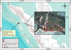
A tsunami is a natural disaster triggered by the vertical displacement of the seafloor following a major earthquake along a megathrust zone. Barus District lies within the active Sumatran megathrust, making it highly vulnerable to large earthquakes that could generate tsunamis. This study aims to map tsunami hazard and risk zones under a 16-meter wave scenario and to model evacuation routes using Geographic Information Systems (GIS) and Remote Sensing approaches. The research employs a descriptive quantitative method, integrating spatial data through overlay and network analysis techniques. The analysis revealed that high-hazard and high-risk zones each cover 0.64 km² out of the total 2.27 km², primarily located in Pasar Terandam and Pasar Batu Gerigis villages. Evacuation route modeling showed estimated travel times ranging from 25.06 to 65.73 minutes, assuming an average walking speed of 1.2 m/s. Among the designated shelters, the Catholic church offers a more efficient route, whereas evacuation to the HKBP church requires more than 60 minutes exceeding the ideal time limit. These findings highlight the urgent need to prioritize disaster mitigation strategies to ensure the effectiveness of tsunami evacuation systems in high-risk coastal areas.
Downloads
References
Anggarwati, A.N.N.H., Mardiatno, D., Mei, E.T.W., 2023. Evaluasi Pemodelan Jalur Evakuasi Tsunami Wilayah Kepesisiran Pantai Krakal dan Pantai Slili Gunungkidul. Bul. Oseanografi Mar. 12, 98–108.
Badan Nasional Penanggulangan Bencana, 2018. Modul 4 Penyusunan Rencana Evakuasi Edisi VII, 10.
Badan Pusat Stastistik Kabupaten Tapanuli Tengah, 2023. Kabupaten Tapanuli Tengah Dalam Angka 2023. Pandan.
Bencana, K.B.N.P., 2014. Peraturan Kepala Badan Nasional Penanggulangan Bencana No 2 Tahun 2012 Tentang Pedoman Umum Pengkajian Risiko Bencana, Peraturan Kepala Badan Nasional Penanggulangan Bencana No 2 Tahun 2012 Tentang Pedoman Umum Pengkajian Risiko Bencana.
Berryman, K., 2006. Review of Tsunami Hazard and Risk in New Zealand. Inst. Geol. Nucl. Sci. 139.
Chaerul, M., T, M.I., Anshari, E., 2026. Engineering , Environment , and Technology Estimation of Tsunami Arrival Time and Run-up Height Using The Cornell Multi-Grid Coupled Tsunami Model ( COMCOT ) at Ujung Bulu and Bira Beaches , Bulukumba Regency , Indonesia 11.
Deliany Putri, T., Muhammad, F., 2019. Analisis Kerentanan Sosial Masyarakat dan Adaptasi Perubahan Iklim di Kampung Gemblakan Atas, Kota Yogyakarta Analysis of Social Vulnerability and Climate Change Adaptation in Gemblakan Atas Village, Yogyakarta City. Proceeding Biol. Educ. Conf. 16, 256–264.
Fathianpour, A., Evans, B., Jelodar, M.B., Wilkinson, S., 2023. Tsunami evacuation modelling via micro-simulation model. Prog. Disaster Sci. 17, 100277.
Ginting, M.R.P., Purba, F.G., Dalimunte, S.M., Rahmadi, M.T., Lubis, D.P., Permana, S., 2023. Pemetaan Prediksi Tingkat Bahaya Tsunami di Kabupaten Tapanuli Tengah. Geo-Image J. 12, 148–161.
Handoyo, G., Sutoyo, S., Syafiudin, M., 2023. Analisis Risiko dan Strategi Mitigasi Bencana Tsunami Di Pesisir Selatan Jawa Studi Kasus : Kabupaten Cilacap. J. Tek. Sipil dan Lingkung. 8, 77–84.
Indah Cahyaning Sari, I Nyoman Suluh Wijaya, F.U., 2020. Penentuan titik evakuasi dan arahan jalur evakuasi desa-desa di sepanjang pesisir kabupaten jember 9.
Latue, T., Latue, P.C., 2023. Analisis Spasial Prediksi Bahaya Tsunami di Kecamatan Salahutu Pulau Ambon. Buana J. Geogr. Ekol. dan Kebencanaan 1, 21–30.
León, J., Gubler, A., Ogueda, A., 2022. Modelling geographical and built-environment attributes as predictors of human vulnerability during tsunami evacuations : a multi-case-study and paths to improvement 2857–2878.
Liu, C., Staes, B.M., Wang, H., 2025. Evacuation time estimates for life safety in Tsunami hazards. Int. J. Disaster Risk Reduct. 119, 105237.
Lubis, L.H., Ayundita, A.A., Sari, N., Wardono, W., 2022. Aktivitas Seismisitas Di Wilayah Sumatera Bagian Utara Menggunakan Arc-Gis Periode 2020-2021. J. Kumparan Fis. 5, 91–98.
Mutaqin, B.W., Hestiwi, A.H., Pertiwi, D., Mardiatno, D., 2023. Penentuan Lokasi dan Jalur Evakuasi Tsunami Berdasarkan Historis Tsunami Gunung Api Anak Krakatau di Pesisir Desa Carita, Banten. J. Lingkung. dan Bencana Geol. 14, 85–95.
Nugroho, P.C., Pinuji, A.H.S.E., Iriansyah, Nugraha, A., S., G.Y., Ichawana, A.N., Wiguna, S., Syauqi, A.W.A., Shabrina, R.E.R.F.Z., Septian, T.U.H.R.T., A., A., 2018. Modul Teknis Penyusunan Kajian Risiko Bencana Tsunami. Direktorat Pengurangan Risiko Bencana Badan Nas. Penanggulangan Bencana 1–95.
Nurhasanah, A., Riady, M.I., Aprizal, A., 2020. Analysis of the Tsunami Evacuation Route in Kunjir Village and Way Muli Village, South Lampung Regency. J. Tek. Sipil 27, 223.
Pertanian, K., 1981. Kriteria dan Tata Cara Penetapan Hutan Lindung. SK Menteri Pertan.
Prihartanto, Akhirianto, N.A., Trisnafiah, S., Ghifari, B.F., Ganesha, D., Yuvhendmindo, M.R., Ainunnisa, F., 2023. Social vulnerability toward tsunami hazard in the coastal area of Bayah Dome Geopark, in Lebak Regency, Banten Province. IOP Conf. Ser. Earth Environ. Sci. 1192.
Putra, I.M.E.K., Chernovita, H.P., 2020. Mapping of Tsunami disaster evacuation pathways based on Tsunami altitude scenario using Network Analyst Method (case study: Palu City, Central Sulawesi). J. Appl. Geospatial Inf. 4, 304–311.
PVMBG, 2023. Katalog Tsunami Indonesia 416-2021. Kementrian Energi dan Sumberdaya Mineral.
Ramailis, N., Sakir, S., 2024. Gender Mainstreaming in Natural Disaster Management: Study of Planning for Strengthening Women’s Capacity Against Disasters in Bantul District. Amalee Indones. J. Community Res. Engagem. 5, 155–170.
Ramalanjaona, G., 2011. Impact of 2004 Tsunami in the Islands of Indian Ocean: Lessons Learned. Emerg. Med. Int. 2011, 1–3.
Rao, A.D., 2006. TSUNAMI TRAVEL TIME COMPUTATION AND SKILL ASSESSMENT FOR THE 26 DECEMBER 2004 EVENT IN THE INDIAN OCEAN The historical records of past tsunamis reveal the most damaging world tsunamis generated by earthquakes during the last 55 years : ( 1 ) 1952 — Kamcha 48, 147–166.
Rapson Okardo Purba, S.P., 2020. Profile Potensi Pulau-Pulau Kecil Untuk Meningkatkan Ekonomi Masyarakat Pesisir Kabupaten Tapanuli Tengah, Sustainability (Switzerland). Dinas Kelautan dan Perikanan Kabupaten Tapanuli Tengah, Tapanuli Tengah.
Sambah, A.B., Miura, F., Guntur, Sunardi, Febriana, A.F., 2019. Geospatial model of physical and social vulnerability for tsunami risk analysis. Int. J. GEOMATE 17, 29–34.
Septiangga, B., 2019. Tsunami Inundation Modeling And Its Impact On Coastal Area Of Tsunami Inundation Modeling And Its Impact On Coastal Area Of Manado City And Surrounding.
Sihombing, S., Sunardi, B., Darmawan, H., 2024. Engineering, Environment , and Technology Tsunami Modeling Using DEMNAS and DEM Data from UAV Surveys for Planning Evacuation Routes on Samas Coast , Bantul Regency 9.
Sinambela, M., Sukanta, I.N., 2022. Pemodelan Peta Bahaya Tsunami Barus, Tapanuli Tengah, Sumatera Utara melalui Sekolah Lapang Geofisika. … Meteorol. Klimatologi Geofis. … 2006, 34–39.
Subarya, C., Chlieh, M., Prawirodirdjo, L., Avouac, J., Bock, Y., Sieh, K., Meltzner, A.J., Natawidjaja, D.H., Mccaffrey, R., 2006. Plate-boundary deformation associated with the great Sumatra – Andaman earthquake 440.
Suharyanto, A., 2012. Predicting Tsunami Inundated Area and Evacuation Road Based On Local Condition Using GIS. IOSR J. Environ. Sci. Toxicol. Food Technol. 1, 05–11.
Suparno, Retno Utami Agung Wiyono, Entin Hidayah, W.K.L., 2023. Tsunami Disaster Risk Assessment Using a Geographic Information System for Puger Sub-District, Jember Regency. J. Tek. Pengair. 14, 13–24.
Susetyo, A., Handayani, W., Awalia, R., Diponegoro, U., Tadulako, U., 2025. SOCIAL VULNERABILITY OF MULTI-HAZARD DISASTER-PRONE AREAS IN PALU CITY , CENTRAL 5, 3940–3950.
Waluyo, F.A., Wardhani, M.K., 2021. Perencanaan Wilayah Pesisir Berbasis Mitigasi Bencana Tsunami Studi Kasus Di Kabupaten Bantul Daerah Istimewa Yogyakarta. Juv. Ilm. Kelaut. dan Perikan. 2, 226–235.
Watik, N., Jaelani, L.M., 2019. Flood evacuation routes mapping based on derived-flood impact analysis from landsat 8 imagery using network analyst method. Int. Arch. Photogramm. Remote Sens. Spat. Inf. Sci. - ISPRS Arch. 42, 455–460.
Widyanti, A.D., Nurhidayati, E., Jurusan, D., Kelautan, T., Teknik, F., Tanjungpura, U., Kerentanan, I., Hilir, M., 2023. Identifikasi tingkat kerentanan sosial dan fisik terhadap abrasi di kecamatan mempawah hilir 1, 2023.
Wijanarko, T., Tondobala, L., Ontang, F., Siregar, P., 2022. Mitigasi Bencana Tsunami Di Wilayah Pesisir Kabupaten Bolaang Mongondow Timur Tsunami Disaster Mitigation in the Coastal Area of East Bolaang Mongondow Regency. J. Spasial 9, 2022.
Wijayanto, M.P., Achmad, A., Mahfud, C.L., Apriyanti, D., Zakia, Z.S., 2025. Engineering , Environment , and Technology Tsunami Evacuation Route Optimization Based on Megathrust Scenario Modeling in Pangandaran , West Java , Indonesia 10, 459–468.
Downloads
Published
Issue
Section
License
Copyright (c) 2026 Journal of Geoscience, Engineering, Environment, and Technology

This work is licensed under a Creative Commons Attribution-ShareAlike 4.0 International License.
Copyright @2019. This is an open-access article distributed under the terms of the Creative Commons Attribution-ShareAlike 4.0 International License which permits unrestricted use, distribution, and reproduction in any medium. Copyrights of all materials published in JGEET are freely available without charge to users or / institution. Users are allowed to read, download, copy, distribute, search, or link to full-text articles in this journal without asking by giving appropriate credit, provide a link to the license, and indicate if changes were made. All of the remix, transform, or build upon the material must distribute the contributions under the same license as the original.


