
Use of the Diffuse Field Assumption (DFA) Method to Determine The Condition of The Subsurface Layer in The Government Office Area of Bengkulu City, Indonesia
DOI:
https://doi.org/10.25299/jgeet.2026.11.02.27025Keywords:
Bengkulu City, Diffuse Field Assumption, Microtremor, Seismic Vulnerability, Vs30Abstract
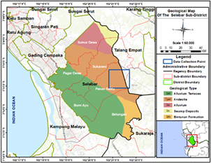
Bengkulu City lies in an earthquake-prone region because of tectonic activity along the Sumatra subduction zone. Subsurface characterization is critical for safe infrastructure planning. This study identifies subsurface conditions in the Bengkulu City Government office area using microtremor data analyzed with the Diffuse Field Assumption (DFA) approach. Researchers recorded 52 measurement points to determine key seismic parameters: dominant frequency (f0), amplification factor (A0), seismic vulnerability index (Kg), and shear wave velocity (Vs30). The results show that f0 values range from 3.57 to 14.8 Hz, A0 from 1.62 to 7.18, Kg from 0.30 to 6.35, and Vs30 from 189.29 to 740.48 m/s, indicating significant spatial variation in subsurface conditions. Areas characterized by low f0, high A0, and low Vs30, particularly at points T33 and T41, are identified as zones with higher seismic vulnerability. The application of the DFA approach enables a more reliable estimation of subsurface shear wave velocity and enhances the interpretation of site effects compared to conventional analysis. These findings highlight the importance of integrated seismic parameter mapping to support earthquake hazard mitigation and urban spatial planning in tectonically active regions.
Downloads
References
Airunisa, Resta, L.I., Ngatijo, 2024. Analisis Data Mikrotremor Untuk Mengetahui Nilai Indeks Kerentanan Seismik Di Kecamatan Jambi Luar Kota. J. Geofis. 22, 21–25.
Anggi, A.P., Refrizon, R., Harlianto, B., Apriyanti, N., Saputri, W., Febriansyah, G.O., Al-ansory, A.R., Raihana, H., Daniel, A., 2025. Analysis of Earthquake Risk Estimation for Sustainable Development Using Microtremor Data Based on Vs30 Distribution : Comparative Study of DFA and Geopsy in Central Bengkulu , Indonesia. J. Ilmu Fis. 17, 214–228.
Apriana, Y., Refrizon, Farid, M., Onawa, J., Hardianza, M., Setyowati, Y., 2025. Analysis of Potential New Flood Basin in Ratu Agung Sub-district Using the HVSR Method. J. Geosci. Eng. Environ. Technol. 10, 356–363.
Badan Meteorologi dan Geofisika, 2007. Database Gempa BMG Kepahyang. Kepahyang.
Badan Meteorologi Klimatologi dan Geofisika, 2010. Sejarah Gempa Bumi Bengkulu dari Tahun 1900. Bengkulu.
Badan Standardisasi Nasional, 2019. SNI 1726:2019 Tata cara perencanaan ketahanan gempa untuk struktur bangunan gedung dan non gedung. Jakarta.
Boore, D.M., 2004. V s ( 30 ) ( or NEHRP Site Classes ) from Shallow Velocity Models ( Depths < 30 m ). Bull. Seismol. Soc. Am. 94, 591–597.
Burrough, P.A., Mcdonnell, R.A., 1998. Principles of Geographical Information Systems.
Farid, M., Mase, L.Z., 2020. Implementation of seismic hazard mitigation on the basis of ground shear strain indicator for spatial plan of Bengkulu city, Indonesia. Int. J. GEOMATE 18, 199–207.
Fauziah, L., Pohan, A.F., 2023. Identifikasi Potensi Longsor di Kota Sawahlunto dengan Menggunakan Parameter Frekuensi Dominan , Amplifikasi , dan Kecepatan Gelombang Geser. J. Fis. Unand 12, 342–348.
García-Jerez, A., Piña-Flores, J., Sánchez-Sesma, F.J., Luzón, F., Perton, M., 2016. A computer code for forward calculation and inversion of the H/V spectral ratio under the diffuse field assumption. Comput. Geosci. 97, 67–78.
Hadi, A.I., Refrizon, R., Halauddin, H., Lidiawati, L., Edo, P., 2021. Interpretasi Tingkat Kekerasan Batuan Bawah Permukaan di Daerah Rawan Gempa Bumi Kota Bengkulu. Indones. J. Appl. Phys. 11, 11.
Januarta, G.H., Yudistira, T., Tohari, A., Ibrahim, E., 2020. Mikrozonasi Seismik Wilayah Padalarang , Kabupaten Bandung Barat Menggunakan Metode Horizontal to Vertical Spectral Ratio. Ris. Geol. dan Pertamb. 30, 143–152.
Kawase, H., Mori, Y., Nagashima, F., 2018. Difference of horizontal ‑ to ‑ vertical spectral ratios of observed earthquakes and microtremors and its application to S ‑ wave velocity inversion based on the diffuse field concept. Earth, Planets Sp. 70, 1–32.
Khalqillah, A., Muksin, U., Simanjutak, A.V.H., Jihad, A., Banyunegoro, H., 2025. Seismic Hazard Estimation for Sumatra and Kalimantan Region Using Event-Based Probabilistic Seismic Hazard Analysis ( EB-PSHA ). J. Geosci. Eng. Environ. Technol. 10, 329–337.
Mayasari, Z.M., Bertham, Y.H., Farid, M., Hadi, A.I., 2025. Identification the Level of Social Vulnerability of the Tsunami Disaster in the Coastal Area of Bengkulu City, Indonesia. J. Geosci. Eng. Environ. Technol. 10, 447–453.
Mozalia, N.P.P., 2024. Identifikasi Kerentanan Gedung Balai Besar Meteorologi Klimatologi Dan Geofisika Wilayah III Denpasar Dengan Metode Horizontal To Vertical Spectral Ratio (HVSR). Αγαη 15, 37–48.
Mulyana, G.D., Antosia, R.M., Nathania, E.Y., 2026. Soft Layer Identification In Kedamaian District Using the HVSR-Derived Shear Wave Velocity Distribution. J. Geosci. Eng. Environ. Technol. 11, 129–139.
Nakamura, Y., 2000. Clear Idetification of Fundamental Idea of Nakamura’s Technique and Its Applications.
Nakamura, Y., 1997. Seismic Vulnerability Indices for Ground and Structures Using Microtremor, in: World Congress on Railway Research, Florence, Nov. 1997. pp. 1–7.
Nakamura, Y., 1989. A Method For Dynamic Characteristics Estimation of Subsurface Using Microtremor on The Ground Surface. Q. Rep. RTRI 30, 25–33.
Natawidjaja D. H., Triyoso, W., 2007. The sumatran fault zone — from source to hazard. J. Earthq. TsunamI 1, 21–47.
Prabowo, U.N., Sehah, S., Ferdiyan, A., 2021. Estimasi ketebalan lapisan sedimen permukaan menggunakan pengukuran mikrotremor di Pemalang, Jawa Tengah. J. Teras Fis. 4, 187.
Putra, A.K., Yatini, Y., Paripurno, E.T., 2023. Application of HVSR Method on Microtremor Data for Analysis of Earthquake Potential in Candipuro District, Lumajang, Indonesia. J. Geosci. Eng. Environ. Technol. 8, 288–294.
Rasyid, A.M., Rochman, J.P.G.N., Widodo, A., Nabiha, M.R., Mikael Mario, P.P., Salam, I.F., 2024. Site classification Based on Shear Wave Velocity Inversion in the Jlantah Dam Construction Project using the HVSR (Horizontal to Vertical Spectral Ratio) Analysis Method. IOP Conf. Ser. Earth Environ. Sci. 1307.
Ridwan, M., Yatini, Y., Pramono, S., 2021. Mapping of Potential Damages Area in Lombok Island Base on Microtremor Data. J. Pendidik. Fis. Indones. 17, 49–59.
Sanchez-Sesma, F.J.S., Rodr´ıguez, M., An-Viveros, U.I., Luz"on, F., Campillo, M., Margerin, L., Garc´ıa-Jerez, A., Suarez, M., Santoyo, M.A., Rodr´ıguez-Castellanos, and A., 2011. A theory for microtremor H/V spectral ratio : application for a layered medium. Geophys. J. Int. 186, 221–225.
SESAME, 2004. Guidelines for The Implementation of The H/V Spectral Ratio Technique on Ambient Vibrations-Measurements, Processing and Interpretations, SESAME European Research Project. SESAME Site Eff. Assess. using Ambient Excit. 1–62.
Setianegara, R., Muslim, D., Ismawan, Marjiyono, 2023. Potensi Penguatan Gelombang Gempabumi oleh Sedimen Permukaan Berdasarkan Analisis Mikrotremor : Studi Kasus di Cekungan Bandung Bagian Selatan. J. Geol. dan Sumberd. Miner. 24, 107–115.
Setiawan, D., Mase, L.Z., Supriani, F., Misliniyati, R., Amri, K., 2025. Studi Resistensi Tanah Berdasarkan Variasi Kedalaman Kecepatan Gelombang Geser (Vs) di Kecamatan Selebar, Kota Bengkulu. J. Geosaintek 11, 153–167.
Siagian, S., Refrizon, Hadi, A.I., 2025. Mapping of Natural Frequency, Amplification, Seismic Vulnerability, and Vs30 Velocity in Selebar District, Bengkulu City. J. Fis. 15, 20–29.
Siregar, A.S., 2023. Penentuan Ketebalan Lapisan Sedimen Menggunakan Metode Inversi Horizontal To Vertical Spectral Ratio (HVSR) Di Kecamatan Selebar Kota Bengkulu. UNIVERSITAS BENGKULU.
Siregar, I.S., Madlazim, 2017. Analisis mikrotremor dengan metode hvsr untuk mengetahui zona penguatan gempa bumi di wilayah stasiun seismik jawa timur. J. Inov. Fis. Indones. 06, 33–38.
Sugianto, N., Farid, M., Suryanto, W., 2016. Local geology condition of Bengkulu city based on seismic vulnerability index (Kg). ARPN J. Eng. Appl. Sci. 11, 4797–4803.
Wibowo, N.B., Fathani, T.F., Pramumijoyo, S., Marliyani, G.I., 2025. The topographic ‑ based v s30 model of the Opak River basin Yogyakarta. Geoenvironmental Disasters 12, 1–15.
Wibowo, N.B., Huda, I., 2020. Analisis Amplifikasi, Indeks Kerentanan Seismik Dan Klasifikasi Tanah Berdasarkan Distribusi Vs30 D.I.Yogyakarta Analysis Of Amplification, Seismic Vulnerability Index And Soil Clasification Based On Vs30 In Yogyakarta. Bul. Meteorol. Klimatologi, Dan Geofis. 1, 21–31.
Yahya, M.H., Ashari, A.E., Syahbana, A.J., Kuntjoro, Y.D., Ahmad, L., 2024. Analysis of Peak Ground Acceleration ( PGA ) and Modified Mercalli Intensity ( MMI ) Scale using PSHA Method in Lampung Province. INERSIA J. Tek. SIPIL DAN Arsit. 20, 254–263.
Downloads
Published
Issue
Section
License
Copyright (c) 2026 Journal of Geoscience, Engineering, Environment, and Technology

This work is licensed under a Creative Commons Attribution-ShareAlike 4.0 International License.
Copyright @2019. This is an open-access article distributed under the terms of the Creative Commons Attribution-ShareAlike 4.0 International License which permits unrestricted use, distribution, and reproduction in any medium. Copyrights of all materials published in JGEET are freely available without charge to users or / institution. Users are allowed to read, download, copy, distribute, search, or link to full-text articles in this journal without asking by giving appropriate credit, provide a link to the license, and indicate if changes were made. All of the remix, transform, or build upon the material must distribute the contributions under the same license as the original.


