
Morphotectonic Identification of the Active Ransiki Fault Zone as a Source of Shallow Seismicity in South Manokwari, West Papua: Integrating Stream Length–Gradient Index and Lineament Analysis
DOI:
https://doi.org/10.25299/jgeet.2026.11.1.26961Keywords:
Active Tectonics, Morphotectonics, SLI, Lineament Mapping, Ransiki Fault Zone, West PapuaAbstract
The Ransiki area, which is in South Manokwari, West Papua, lies in a tectonically active transition zone related to the oblique convergence between the Indo-Australian and Pacific plates. Although shallow seismic activity has already been detected, the geometry and seismo-tectonic behavior of local fault structures have not been characterized yet. This work aims to explore the morphotectonic framework of the region by combining quantitative geomorphic indices and structural evidence. From 8–30 m resolution DEMNAS data multi-azimuth lineaments were extracted and Stream Length–Gradient Index (SLI) was derived on 42 river segments. The distribution of lineament density and SLI anomalies were correlated using Pearson coefficient and verified with field observation of fault scarps, triangular facets and slickensides. The results show relevant NNW–SSE lineaments (N330°-N340°E) having high local SLI values (>500) that are more concentrated in the eastern sector of Ransiki. Field evidences evidence envisage an active sinistral strike-slip deformation along this trend. These combined geomorphic- and structural-based indicators attest the actively deforming character of the Ransiki Fault Zone as a transpressional shear corridor that transfers deformation between the Sorong Fault System and the Arfak upliftement. The methodology applied in this case study offers an efficient tool to identify active faults in tropical regions with sparse geophysical ground data and provides valuable input for seismic hazard assessment in eastern Indonesia.
Downloads
References
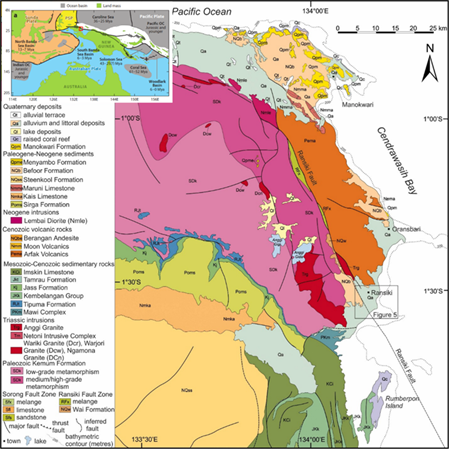
Atmawinata, S., Suwarti, T. and Siddiquie, H.N., 1989. Geological map of Manokwari Quadrangle, Irian Jaya (scale 1:250,000). Geological Research and Development Centre, Bandung.
Baldwin, S.L., Fitzgerald, P.G. and Webb, L.E., 2012. Tectonics of the New Guinea region. Annual Review of Earth and Planetary Sciences, 40, pp.495–520.
BIG (Badan Informasi Geospasial), 2021. Digital Elevation Model Nasional (DEMNAS). Available at: https://tanahair.indonesia.go.id (Accessed: year).
Bishop, P., 2017. Drainage rearrangement and tectonics in active orogens: Insights from knickpoint migration. Earth-Science Reviews, 168, pp.103–131.
BMKG (Badan Meteorologi, Klimatologi, dan Geofisika), 2023. Earthquake catalog of Indonesia. BMKG, Jakarta.
Brardinoni, F., Hassan, M.A. and Slaymaker, O., 2022. Knickpoint clusters as geomorphic markers of active tectonics. Geomorphology, 401, 108138.
Chorowicz, J., 2005. The East African Rift System. Journal of African Earth Sciences, 43(1–3), pp.379–410.
Cox, S.C. and Barrell, D.J.A., 2020. Active faulting and landscape response in tectonically active regions. Earth Surface Processes and Landforms, 45(9), pp.2013–2031.
Degroot, P. and Hall, R., 2020. Strike-slip deformation along the northern New Guinea margin. Tectonophysics, 791, 228553.
Duvall, A., Clark, M.K. and Avdeev, B., 2021. Fault zone kinematics and river incision linked to active tectonics. Journal of Geophysical Research: Earth Surface, 126(9), e2021JF006138. Hamdouni, R., Irigaray, C., Fernández, T., Chacón, J. and Keller, E.A., 2008. Relative active tectonics assessment based on morphometric analysis. Geomorphology, 96(1–2), pp.166–183.
Fisher, D.M. and Brandon, M.T., 2021. Transpression and crustal thickening in obliquely convergent margins. Geology, 49(11), pp.1425–1429.
Ganas, A., Pavlides, S.B. and Karastathis, V., 2017. Active fault segmentation in Greece. Tectonophysics, 694, pp.51–65.
Gomes, C.F.O. et al., 2019. Automated lineament extraction and tectonic interpretation. Remote Sensing, 11(21), 2503.
Hack, J.T., 1973. Stream-profile analysis and stream-gradient index. USGS Journal of Research, 1(4), pp.421–429.
Hall, R., 2002. Cenozoic tectonics of SE Asia and the SW Pacific. Journal of Asian Earth Sciences, 20(4), pp.353–431.
Hall, R. and Spakman, W., 2015. Subduction in Southeast Asia and the SW Pacific. Journal of Geophysical Research: Solid Earth, 120, pp.219–235.
Hill, E.M., Briggs, R.W. et al., 2015. Contemporary deformation along the Sorong Fault Zone from GPS. Geophysical Journal International, 203(2), pp.1315–1327.
Kumar, P., Singh, R.P. and Malik, I., 2023. River steepness and active tectonics in the Himalayan foreland. Geomorphology, 430, 108794.
Li, G., Crosby, B.T. et al., 2022. River steepness as an indicator of active fault growth. Earth and Planetary Science Letters, 595, 117797.
Moucha, R. and Forte, A.M., 2023. Crustal deformation and landscape signal propagation. Nature Geoscience, 16, pp.251–259.
Nugraha, M.F., Pesicek, J.D., Widiyantoro, S., Gunawan, E. and Thurber, C.H., 2020. Seismotectonics of eastern Indonesia. Journal of Geophysical Research: Solid Earth, 125(3), e2019JB018904.
Pertamina, 2010. Geological and structural evaluation report of the Arfak region. Pertamina EP, Jakarta.
Pubellier, M. and Hall, R., 2014. Microcontinent formation in East Indonesia. Geological Society, London, Special Publications, 441, pp.1–28.
PUSGEN, 2017. Peta sumber dan bahaya gempa Indonesia 2017. Kementerian PUPR, Jakarta.
Raimondo, S. and Steer, P., 2020. Transpressional faulting and river network reorganization. Tectonics, 39(10), e2020TC006300.
Ramos, V.A., 2021. Strike-slip segmentation and seismic hazard. Lithosphere, 2021, pp.1–18.
Sapkota, S.N., Bollinger, L. and Tapponnier, P., 2018. Active faulting in steep mountain belts. Tectonophysics, 744, pp.315–329.
Sulistiyono, D., Santoso, D.R. and Handayani, L., 2019. Identification of active faults in Java using morphometric indices. Indonesian Journal of Geoscience, 6(1), pp.15–27.
Tjia, H.D., 1972. The Sorong Fault Zone, northern New Guinea. Geological Society of Malaysia Bulletin, 5, pp.37–51.
Wirastuti, R., Widagdo, B. and Hidayat, F., 2021. Neotectonic activity assessment in Lombok Island, Indonesia. Jurnal Geologi dan Sumberdaya Mineral, 22(3), pp.155–168.
Wobus, C.W., Crosby, B.T. and Whipple, K.X., 2021. Knickpoint propagation and surface uplift. Geological Society of America Bulletin, 133(7–8), pp.1411–1425.
Downloads
Published
Issue
Section
License
Copyright (c) 2026 Journal of Geoscience, Engineering, Environment, and Technology

This work is licensed under a Creative Commons Attribution-ShareAlike 4.0 International License.
Copyright @2019. This is an open-access article distributed under the terms of the Creative Commons Attribution-ShareAlike 4.0 International License which permits unrestricted use, distribution, and reproduction in any medium. Copyrights of all materials published in JGEET are freely available without charge to users or / institution. Users are allowed to read, download, copy, distribute, search, or link to full-text articles in this journal without asking by giving appropriate credit, provide a link to the license, and indicate if changes were made. All of the remix, transform, or build upon the material must distribute the contributions under the same license as the original.


