
A GIS-Based Multicriteria Decision Framework for Provincial and Regional Distribution Centers: Integrating Land Capability (SKL) and Accessibility Metrics in South Kalimantan, Indonesia
DOI:
https://doi.org/10.25299/jgeet.2026.11.1.26825Keywords:
GIS-MCDA, Land Capabilities, Regional Logistics, Distribution Center, South KalimantanAbstract
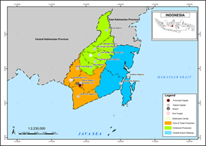
This study develops a GIS-based multicriteria decision analysis (GIS-MCDA) framework to identify priority locations for Provincial Distribution Centers (PDP) and Regional Distribution Centers (PDR) in South Kalimantan Province. Its principal contribution is the integration of Land Capability Units (SKL), which represent the intrinsic physical suitability of land, with accessibility and utility indicators that capture operational support. The framework employs a vector-overlay procedure that combines thematic layers, standardized scores, and a Weighted Linear Combination (WLC). The SKL component is weighted at 0.55, while the accessibility-utility component is weighted at 0.45, reflecting the premise that physical land suitability constitutes a fundamental threshold that cannot be fully offset by high accessibility alone. The results show that class S2 dominates the study area, covering 1,566,737.61 ha (42.22%), followed by S3 at 1,037,104.41 ha (27.95%) and S4 at 1,004,058.64 ha (27.06%). By contrast, S1 covers only 68,751.95 ha (1.85%), while class N accounts for 34,496.78 ha (0.93%). These findings indicate that most of South Kalimantan is conditionally suitable, meaning that PDP/PDR development generally still requires technical adjustment, infrastructure improvement, or a combination of both. Spatially, the most prospective areas are concentrated in the Banjarbakula metropolitan corridor and several strategic logistics nodes. Overall, the study demonstrates that distribution center location decisions should simultaneously account for physical land resilience and operational efficiency in order to support more adaptive, measurable, and policy-relevant regional logistics planning
Downloads
References
Abd, A., Karim, E., Awawdeh, M.M., 2020. Integrating GIS Accessibility and Location-Allocation Models with Multicriteria Decision Analysis for Evaluating Quality of Life in Buraidah City , KSA.
Abdrabo, K.I., Kantoush, S.A., Esmaiel, A., Saber, M., Sumi, T., Almamari, M., Elboshy, B., Ghoniem, S., 2023. An integrated indicator-based approach for constructing an urban flood vulnerability index as an urban decision-making tool using the PCA and AHP techniques: A case study of Alexandria, Egypt. Urban Climate 48, 101426.
Amin, C., Wahab Hasyim, A., Sun’an, M., Yetty, Millanida Hilman, R., Fahmiasari, H., 2024. Impact of increasing local economic capacity on reducing maritime logistics costs in island Province of eastern Indonesia: A dynamic system approach. Transportation Research Interdisciplinary Perspectives 27, 101195.
Anteneh, Z.L., 2021. Appraising groundwater potential zones using geospatial and multi-criteria decision analysis ( MCDA ) techniques in Andasa-Tul watershed , Upper Blue Nile basin , Ethiopia.
Boix-Cots, D., Pardo-Bosch, F., Pujadas, P., 2023. A systematic review on multi-criteria group decision-making methods based on weights: Analysis and classification scheme. Inf Fusion 96, 16–36.
Chumaidiyah, E., Dewantoro, M.D.R., Fauzi, P.M., Kamil, A.A., 2023. Selection of Industrial Sites Using a Web-Based Geographical Information System to Minimize Risks : A Case Study in West Java , Indonesia.
Dehimi, S., 2021. THE USE OF NEW TECHNIQUES IN SPATIAL MODELING AND ANALYSIS OF URBAN QUALITY OF LIFE : MULTIPLE-CRITERIA DECISION ANALYSIS AND GIS 35, 355–363.
Delamater, P., Messina, J., Shortridge, A., Grady, S., 2012. Measuring geographic access to health care: raster and network-based methods. International Journal of Health Geographics 11, 15.
Deng, F., Li, Xiaobing, Wang, H., Zhang, M., Li, R., Li, Xu, 2014. GIS-based assessment of land suitability for alfalfa cultivation : a case study in the dry continental steppes of northern China 12, 364–375.
Dragi, A. van, 2024. Machine Learning for Criteria Weighting in GIS-Based.
Ergün, M., 2025. Planning Sustainable Food Systems: GIS Based Greenhouse Site Selection and Green Logistics Integration in the Eastern Black Sea Region. Black Sea Journal of Agriculture.
Feng, Z., Li, G., Wang, W., Zhang, L., Xiang, W., 2023. International Journal of Disaster Risk Reduction Emergency logistics centers site selection by multi-criteria decision-making and GIS. International Journal of Disaster Risk Reduction 96, 103921.
Hani, H.M., Nour, M.M., Din, E., Khalifa, A., Elalfy, E., 2023. Sensitivity Analysis for Multi-Criteria Decision Analysis Framework for Site Selection of Aquifer Recharge with Reclaimed Water.
Hartati, T.M., Sunarminto, B.H., Nuryani, S., Utami, H., Purwanto, B.H., Nurudin, M., Aji, K., 2023. Distribution of soil morphology and physicochemical properties to assess the evaluation of soil fertility status using soil fertility capability classification in North Galela , Indonesia 10, 4405–4415.
Kannan, D., Moazzeni, S., Darmian, S.M., Afrasiabi, A., 2021. A hybrid approach based on MCDM methods and Monte Carlo simulation for sustainable evaluation of potential solar sites in east of Iran. Journal of Cleaner Production 279, 122368.
Khalqillah, A., Muksin, U., Simanjutak, A.V.H., Jihad, A., Banyunegoro, H., 2025. Engineering , Environment , and Technology Seismic Hazard Estimation for Sumatra and Kalimantan Region Using Event-Based Probabilistic Seismic Hazard Analysis ( EB-PSHA ) 10, 329–337.
Kim, J., 2022. Journal of Smart Tourism 1, 3–7.
Kourtzanidis, K., Angelakoglou, K., Apostolopoulos, V., Giourka, P., Nikolopoulos, N., 2021. Assessing Impact, Performance and Sustainability Potential of Smart City Projects: Towards a Case Agnostic Evaluation Framework. Sustainability.
Kukulska, A., Salata, T., Cegielska, K., Szylar, M., 2019. METHODOLOGY OF EVALUATION AND CORRECTION OF GEOMETRIC DATA TOPOLOGY IN QGIS SOFTWARE. Acta Scientiarum Polonorum Formatio Circumiectus.
Lemenkova, P., Debeir, O., 2023. GDAL and PROJ Libraries Integrated with GRASS GIS for Terrain Modelling of the Georeferenced Raster Image. Technologies.
Li, L., Wang, J., Wang, H., Jin, X., Du, L., 2023. Intermodal transportation hub location optimization with governments subsidies under the Belt and Road Initiative. Ocean & Coastal Management 231, 106414.
Lifeng Li, 2021. The state of the world’s land and water resources for food and agriculture, in: The State of the World’s Land and Water Resources for Food and Agriculture.
Malczewski, J., 2007. GIS ‐ based multicriteria decision analysis : a survey of the literature 8816.
Molla, M.B., 2024. Potential landfill site selection for solid waste disposal using GIS-based multi-criteria decision analysis (MCDA) in Yirgalem Town, Ethiopia. Cogent Engineering 11, 2297486.
Montgomery, B., Dragic, S., 2016. Comparison of GIS-Based Logic Scoring of Preference and Multicriteria Evaluation Methods : Urban Land Use Suitability.
Mulualem, B., Ayenew, T., Tesfaw, G., Jothimani, M., Mulualem, W., 2025. Geospatial and multi-criteria decision analysis for sustainable solid waste disposal site selection in Debre Tabor, Ethiopia. Discover Sustainability 6, 475.
Onstein, A.T.C., Tavasszy, L.A., Damme, D.A. Van, Onstein, A.T.C., Tavasszy, L.A., Damme, D.A. Van, 2019. Factors determining distribution structure decisions in logistics : a literature review and research agenda 1647.
Özder, E.H., 2025. A Sustainable Multi-Criteria Decision-Making Framework for Online Grocery Distribution Hub Location Selection.
Petris, M., Archetti, C., Cattaruzza, D., Ogier, M., Semet, F., 2024. A Branch-Price-and-Cut algorithm for the Multi-Commodity two-echelon Distribution Problem. EURO Journal on Transportation and Logistics 13, 100139.
Razvanchy, H.A.S., Fayyadh, M.A., 2022. of Agricultural Sciences GIS and AHP Based Techniques for Agricultural Land Suitability Assessment in Erbil Province , Kurdistan region , Iraq Materials & Methods.
Retamero, J.M., Orive, A.C., 2025. Optimizing Intermodal Port–Inland Hub Systems in Spain: A Capacitated Multiple-Allocation Model for Strategic and Sustainable Freight Planning. Journal of Marine Science and Engineering.
Rizki, F., Dewi, A., Situmorang, L., Wau, N., Lubis, Z., Anurogo, W., 2017a. Mapping Of Vegetation And Mangrove Distribution Level In Batam Island Using SPOT-5 Satellite Imagery 02, 264–267.
Rizki, F., Situmorang, A.D.L., Wau, N., Lubis, M.Z., Anurogo, W., 2017b. Mapping Of Vegetation And Mangrove Distribution Level In Batam Island Using SPOT-5 Satellite Imagery. Journal of Geoscience, Engineering, Environment, and Technology 2, 264.
Taki, H.M., Maatouk, M.M.H., 2018. Spatial Statistical Analysis for Potential Transit Oriented Development ( TOD ) in Jakarta Metropolitan Region 03, 47–56.
Taki, H.M., Maatouk, M.M.H., Qurnfulah, E.M., Aljoufie, M.O., 2017. Engineering , Environment , and Technology Planning TOD with land use and transport integration : a review 02, 84–94.
Vargas-Muñoz, J.C., Sanchez-Nitola, F.A., Adarme Jaimes, W., Rios, R., 2025. Enhancing Logistical Performance in a Colombian Citrus Supply Chain Through Joint Decision Making: A Simulation Study. Logistics.
Ye, A., Cai, J., Yang, Z., Deng, Y., Li, X., 2025. The Impact of Intelligent Logistics on Logistics Performance Improvement. Sustainability.
Yin, S., Li, J., Liang, J., Jia, K., Wang, Y., 2020. Optimization of the Weighted Linear Combination Method for Agricultural Land Suitability Evaluation Considering Current Land Use and Regional Differences. Sustainability.
Younes, A., Abu, M.O., Al-sabbagh, T.A., Eid, H.N., El-shenawy, M.A., 2026. Socio-Economic Planning Sciences Spatial suitability and facility location planning for ammunition depots in Egypt : An integrated GIS-based MCDM approach 103.
Yu, H., Shi, A., Liu, Q., Liu, J., Hu, H., Chen, Z., 2025. Immune-Inspired Multi-Objective PSO Algorithm for Optimizing Underground Logistics Network Layout with Uncertainties: Beijing Case Study. Sustainability.
Zamroni, A., Kurniati, A.C., Nur, H., Prasetya, E., 2020. Engineering , Environment , and Technology The assessment of landslides disaster mitigation in Java Island , Indonesia : a review 5, 124–128.
Zhai, X., Yi, M., An, Z., Li, K., 2025. Evaluating land capability using site assessment and land evaluation model in GIS in a watershed scale. Scientific Reports 15, 17767.
Downloads
Published
Issue
Section
License
Copyright (c) 2026 Journal of Geoscience, Engineering, Environment, and Technology

This work is licensed under a Creative Commons Attribution-ShareAlike 4.0 International License.
Copyright @2019. This is an open-access article distributed under the terms of the Creative Commons Attribution-ShareAlike 4.0 International License which permits unrestricted use, distribution, and reproduction in any medium. Copyrights of all materials published in JGEET are freely available without charge to users or / institution. Users are allowed to read, download, copy, distribute, search, or link to full-text articles in this journal without asking by giving appropriate credit, provide a link to the license, and indicate if changes were made. All of the remix, transform, or build upon the material must distribute the contributions under the same license as the original.


