
Identification the Level of Social Vulnerability of the Tsunami Disaster in the Coastal Area of Bengkulu City, Indonesia
DOI:
https://doi.org/10.25299/jgeet.2025.10.4.24177Keywords:
Bengkulu City, Coastal Area, Social Indicators, Social Vulnerability, TsunamiAbstract
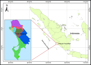
This study investigates the spatial dynamics of social vulnerability to tsunami hazards in Bengkulu City by applying the BNPB (2012) framework as a national reference for index-based assessments. Five key social indicators: population density, gender ratio, poverty, disability, and age were analyzed using spatial techniques and secondary socio-demographic data to identify spatial disparities in vulnerability across sub-districts. The findings reveal that Teluk Segara and Ratu Samban Sub-Districts are the most socially vulnerable areas, driven not only by high population density and poverty but also by their low-lying coastal topography, direct exposure to the Indian Ocean, and limited evacuation accessibility. In contrast, inland sub-districts such as Selebar and Singaran Pati demonstrate lower vulnerability levels due to their higher elevation and greater distance from the coast. These spatial variations indicate that social vulnerability in Bengkulu City is strongly influenced by the interaction between socio-economic vulnerability and oceanographic conditions. The study emphasizes the importance of integrating social and oceanographic dimensions into tsunami risk assessments to better reflect site-specific realities and support more effective mitigation planning. Teluk Segara and Ratu Samban Sub-Districts need to be a priority for targeted preparedness efforts, improved evacuation infrastructure, and the restoration of coastal ecosystems is essential to reduce tsunami impacts. The results contribute to advancing integrated coastal disaster risk management in Indonesia by reinforcing the need to link human vulnerability with coastal environmental processes to achieve sustainable and resilient coastal communities.
Downloads
References
BNPB. (2012). Peraturan Kepala Badan Nasional Penanggulangan Bencana No. 02 Tahun 2012 tentang Pedoman Umum Pengkajian Resiko Bencana. Jakarta.
BPS Kota Bengkulu. (2023). Kota Bengkulu Dalam Angka 2024.
Chen, W., Cutter, S. L., Emrich, C. T., & Shi, P. (2013). Measuring social vulnerability to natural hazards in the Yangtze River Delta region, China. International Journal of Disaster Risk Science, 4(4), 169–181.
Destrayanti, I., Fatmasari, N., Utaminingtyas, B., & Wibowo, H. S. (2023). Tsunami Hazard Mapping and Evacuation Path Determination using field Survey and Geographical Information Systems at Widarapayung Wetan, Cilacap. E3S Web of Conferences, 447.
Faiez, Z., & Fan, D. (2023). Study of Coastal Morphological Changes by Tsunamis in Aceh (Indonesia) Using Satellite Images. Journal of Geoscience, Engineering, Environment, and Technology, 8(4), 295–304.
Fatemi, F., Ardalan, A., Aguirre, B., Mansouri, N., & Mohammadfam, I. (2017). Social vulnerability indicators in disasters: Findings from a systematic review. International Journal of Disaster Risk Reduction, 22, 219–227.
Fathiyah, D. U., Arhatin, R. E., & Siregar, V. P. (2024). Analysis of vulnerability level to tsunami on the Bengkulu City coastal using Geographic Information System. BIO Web of Conferences, 106.
Fauzi, Y., Hardiansyah, Mayasari, Z. M., & Susanto, A. (2022). Spatial Modeling of Tsunamis and Tsunami Inundation Analysis of “Panjang” Beach in Bengkulu City, Indonesia. Science of Tsunami Hazard, 41(1), 95–108.
Fauzi, Y., Susilo, B., & Mayasari, Z. M. (2009). Analisis Kesesuaian Lahan Wilayah Pesisir Kota Bengkulu Melalui Perancangan Model Spasial dan Sistem Informasi Geografis (SIG). Forum Geografi, 23(2), 101–111.
Girl, T., Simbolon, L., Simanungkalit, D. B., Marpaung, R., Sihombing, F. T., Siallagan, A. P., Silalahi, M. M., Rut, S., Tobing, M. L., Adi, J., Simbolon, P., Ramadhan, T., Studi, P., Pancasila, P., & Kewarganegaraan, D. (2024). Analisis Dampak dan Strategi Pengendalian Kerusakan Mangrove Pesisir Sumatera Utara. Jurnal Relasi Publik, 2(2), 10–20.
Hadi, F., & Damayanti, A. (2019). Mapping vulnerability level of tsunami disaster in Coastal Villages of Pariaman City, West Sumatera. IOP Conference Series: Earth and Environmental Science, 311(1).
Lamonge, A. S. L., Polii, G. B., Laka, A. A. M. L., Simanjuntak, A. V. H., Tangkulung, G. G., Timbuleng, J. V. D., Anggriani, T., & Lewi Ristiyono. (2024). The Needs of Public Health Mitigation as The Impact of Earthquake Disasters in North Sulawesi Region, Indonesia. Journal of Geoscience, Engineering, Environment, and Technology, 9(04), 453–460.
Lestari, D. A., Damar, A., Kurniawan, F., & Wayan Nurjaya, I. (2024). Roughness Ecosystem-based Approach to Estimate the Exposure Area of Tsunami on a Coastal City: A Case Study in Bengkulu City, Indonesia. International Journal on Advanced Science Engineering Information Technology, 14(4), 1373–1382.
Lin, W. Y., & Hung, C. T. (2016). Applying spatial clustering analysis to a township-level social vulnerability assessment in Taiwan. Geomatics, Natural Hazards and Risk, 7(5), 1659–1676.
Madden, E. H., Bader, M., Behrens, J., Van Dinther, Y., Gabriel, A. A., Rannabauer, L., Ulrich, T., Uphoff, C., Vater, S., & Van Zelst, I. (2021). Linked 3-D modelling of megathrust earthquake-tsunami events: From subduction to tsunami run up. Geophysical Journal International, 224(1), 487–516.
Mah, J. C., Penwarden, J. L., Pott, H., Theou, O., & Andrew, M. K. (2023). Social vulnerability indices: a scoping review. BMC Public Health, 23(1).
Maharani, Y. N., Lee, S., & Ki, S. J. (2016). Social vulnerability at a local level around the Merapi volcano. International Journal of Disaster Risk Reduction, 20, 63–77.
Mase, L. Z., & Keawsawasvong, S. (2022). Seismic Hazard Maps of Bengkulu City, Indonesia, Considering Probabilistic Spectral Response for Medium and Stiff Soils. The Open Civil Engineering Journal, 16(1).
Mase, L. Z., Sugianto, N., & Refrizon. (2021). Seismic hazard microzonation of Bengkulu City, Indonesia. Geoenvironmental Disasters, 8(1).
Mauro, M. Di, Megawati, K., Cedillos, V., & Tucker, B. (2013). Tsunami risk reduction for densely populated Southeast Asian cities: Analysis of vehicular and pedestrian evacuation for the city of Padang, Indonesia, and assessment of interventions. Natural Hazards, 68(2), 373–404.
Nabillah, R., Setiawan, I., & Waluya, B. (2020). Kerentanan Sosial pada Wilayah Potensi Bencana Tsunami di Pesisir Kecamatan Rajabasa Kabupaten Lampung Selatan. Jurnal Geografi, Edukasi Dan Lingkungan (JGEL), 4(2), 96–112.
Ondara, K., Dhiauddin, R., Wisha, U. J., & Rahmawan, G. A. (2020). Hydrodynamics Features and Coastal Vulnerability of Sayung Sub-District, Demak, Central Java, Indonesia. Journal of Geoscience, Engineering, Environment, and Technology, 5(1), 32–39.
Paris, R., Switzer, A. D., Belousova, M., Belousov, A., Ontowirjo, B., Whelley, P. L., & Ulvrova, M. (2014). Volcanic tsunami: A review of source mechanisms, past events and hazards in Southeast Asia (Indonesia, Philippines, Papua New Guinea). In Natural Hazards (Vol. 70, Issue 1, pp. 447–470). Kluwer Academic Publishers.
Qin, Y., Chen, J., Singh, S. C., Hananto, N., Carton, H., & Tapponnier, P. (2024). Assessing the Risk of Potential Tsunamigenic Earthquakes in the Mentawai Region by Seismic Imaging, Central Sumatra. Geochemistry, Geophysics, Geosystems, 25(5).
Qüense, J., Martínez, C., León, J., Aránguiz, R., Inzunza, S., Guerrero, N., Chamorro, A., & Bonet, M. (2022). Land cover and potential for tsunami evacuation in rapidly growing urban areas. The case of Boca Sur (San Pedro de la Paz, Chile). International Journal of Disaster Risk Reduction, 69.
Ratnasari, R. N., Tanioka, Y., & Gusman, A. R. (2020). Determination of Source Models Appropriate for Tsunami Forecasting: Application to Tsunami Earthquakes in Central Sumatra, Indonesia. Pure and Applied Geophysics, 177(6), 2551–2562.
Satake, K. (2015). Geological and historical evidence of irregular recurrent earthquakes in Japan. Philosophical Transactions of the Royal Society A: Mathematical, Physical and Engineering Sciences, 373.
Saulsberry, L., Bhargava, A., Zeng, S., Gibbons, J. B., Brannan, C., Lauderdale, D. S., & Gibbons, R. D. (2023). The social vulnerability metric (SVM) as a new tool for public health. Health Services Research, 58(4), 873–881.
Sihombing, S., Sudarmaji, Sunardi, B., & Darmawan, H. (2024). Tsunami Modeling Using DEMNAS and DEM Data from UAV Surveys for Planning Evacuation Routes on Samas Coast, Bantul Regency. Journal of Geoscience, Engineering, Environment, and Technology, 9(2), 152–157.
Supendi, P., Widiyantoro, S., Rawlinson, N., Yatimantoro, T., Muhari, A., Hanifa, N. R., Gunawan, E., Shiddiqi, H. A., Imran, I., Anugrah, S. D., Daryono, D., Prayitno, B. S., Adi, S. P., Karnawati, D., Faizal, L., & Damanik, R. (2023). On the potential for megathrust earthquakes and tsunamis off the southern coast of West Java and southeast Sumatra, Indonesia. Natural Hazards, 116(1), 1315–1328.
Triyoso, W., Kongko, W., Prasetya, G. S., & Suwondo, A. (2024). Study on earthquake and tsunami hazard: evaluating probabilistic seismic hazard function (PSHF) and potential tsunami height simulation in the coastal cities of Sumatra Island. Frontiers in Built Environment, 10.
Wirp, A. S., Gabriel, A. A., Schmeller, M., Elizabeth, H. M., van Zelst, I., Krenz, L., van Dinther, Y., & Rannabauer, L. (2021). 3D Linked Subduction, Dynamic Rupture, Tsunami, and Inundation Modeling: Dynamic Effects of Supershear and Tsunami Earthquakes, Hypocenter Location, and Shallow Fault Slip. Frontiers in Earth Science, 9.
Zamroni, A., Kurniati, A. C., & Prasetya, H. N. E. (2020). The assessment of landslides disaster mitigation in Java Island, Indonesia: a review. Journal of Geoscience, Engineering, Environment, and Technology, 5(3), 139–144.
Downloads
Published
Issue
Section
License
Copyright (c) 2025 Journal of Geoscience, Engineering, Environment, and Technology

This work is licensed under a Creative Commons Attribution-ShareAlike 4.0 International License.
Copyright @2019. This is an open-access article distributed under the terms of the Creative Commons Attribution-ShareAlike 4.0 International License which permits unrestricted use, distribution, and reproduction in any medium. Copyrights of all materials published in JGEET are freely available without charge to users or / institution. Users are allowed to read, download, copy, distribute, search, or link to full-text articles in this journal without asking by giving appropriate credit, provide a link to the license, and indicate if changes were made. All of the remix, transform, or build upon the material must distribute the contributions under the same license as the original.


