
Tsunami Evacuation Route Optimization Based on Megathrust Scenario Modeling in Pangandaran, West Java, Indonesia
DOI:
https://doi.org/10.25299/jgeet.2025.10.4.23739Keywords:
Megathrust, Tsunami, Evacuation Routes, PangandaranAbstract
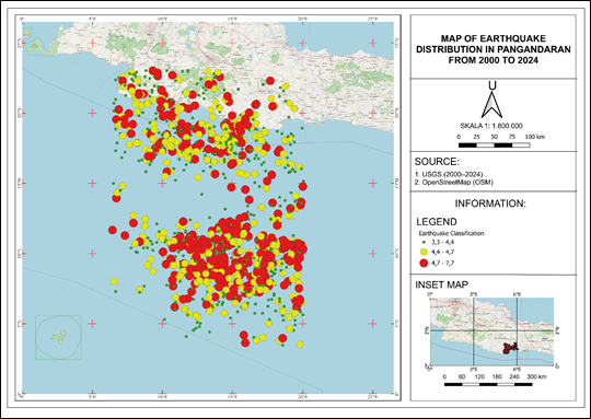
The southern coastal area of West Java, particularly Pangandaran, faces a high risk of tsunami disasters triggered by megathrust earthquakes. However, current evacuation strategies in the region often lack integration between seismic hazard analysis, tsunami wave propagation modeling, and evacuation route optimization. To address this gap, this study aims to develop an integrated framework that combines seismicity assessment, tsunami simulation, and optimal evacuation planning for the Pangandaran coastal region. Seismic records from 2000 to 2024 indicate a total of 3090 earthquake events, predominantly offshore, with magnitudes ranging from low to moderate. The estimated b-value (1.19 ± 0.04) and a-value (8.057) reflect significant tectonic stress within the subduction zone between the Indo-Australian and Eurasian plates. Spatial analysis highlights offshore zones as areas of elevated seismic risk with the potential for large-magnitude events. Tsunami modeling was performed using the COMCOT model under a scenario of an 8.7 Mw megathrust earthquake. The simulation revealed maximum wave heights of up to 18.59 meters, reaching the coast within 40–45 minutes. Natural features such as coastal conservation zones were observed to reduce wave intensity, underscoring their role in hazard mitigation. Evacuation route modeling was carried out using Dijkstra’s algorithm, with two designated starting points located in the eastern and western sectors of Pangandaran Beach. The optimal routes identified to a designated Temporary Evacuation Site (TES) produced travel distances of 1.093 km and 0.533 km, requiring 26.23 and 12.79 minutes respectively, both within the available time window before tsunami impact. The findings offer actionable input for local disaster preparedness and evacuation planning. Furthermore, this study demonstrates the practical application of graph theory in disaster mitigation and provides a scalable framework for tsunami-prone regions worldwide.
Downloads
References
Ammon, C.J., Kanamori, H., Lay, T., Velasco, A.A., 2006. The 17 July 2006 Java tsunami earthquake. Geophys. Res. Lett. 33, 2006GL028005.
Arubi, D., Zulfakriza, Rosalia, S., Sahara, D.P., Puspito, N.T., 2022. Estimation of B-Value Variation as Earthquake Precursor in Java Region with Maximum Likelihood Method. IOP Conf. Ser. Earth Environ. Sci. 1047, 012027.
Ashar, F., Amaratunga, D., Haigh, R., 2018. Tsunami Evacuation Routes Using Network Analysis: A case study in Padang. Procedia Eng. 212, 109–116.
Benazir, Triatmadja, R., Syamsidik, Nizam, Warniyati, 2024. Vegetation-based approached for tsunami risk reduction: Insights and challenges. Prog. Disaster Sci. 23, 100352.
Darmi, Y., Soerowirdjo, B., Wibowo, E., Ernastuti, 2019. Dijkstra algorithm application to determine the evacuation routes simulation earthquake and tsunami in the City Bengkulu based on GIS. J. Adv. Res. Dyn. Control Syst. 11, 1871–1887.
DeMets, C., Gordon, R.G., Argus, D.F., 2010. Geologically current plate motions. Geophys. J. Int. 181, 1–80.
Faiez, Z., Fan, D., 2023. Study of Coastal Morphological Changes by Tsunamis in Aceh (Indonesia) Using Satellite Images. J. Geosci. Eng. Environ. Technol. 8, 295–304.
Fathianpour, A., Evans, B., Babaeian Jelodar, M., Wilkinson, S., 2024. Environmental factors in tsunami evacuation simulation: topography, traffic jam, human behaviour. Nat. Hazards 120, 12797–12815.
Felix, R., Hubbard, J., Wilson, K., Switzer, A., 2024. Heatmap analysis of modeled coastal tsunamis using different bathymetry data resolutions. Geosci. Lett. 11.
Ferreira, M.A., Oliveira, C.S., Francisco, R., 2025. Tsunami risk mitigation: the role of evacuation routes, preparedness and urban planning. Nat. Hazards 121, 6719–6751.
Forcael, E., González, V., Orozco, F., Vargas, S., Pantoja, A., Moscoso, P., 2014. Ant Colony Optimization Model for Tsunamis Evacuation Routes. Comput.-Aided Civ. Infrastruct. Eng. 29, 723–737.
Fujii, Y., Satake, K., 2006. Source of the July 2006 West Java tsunami estimated from tide gauge records. Geophys. Res. Lett. 33, 2006GL028049.
Gunawan, E., Meilano, I., Abidin, H.Z., Hanifa, N.R., Susilo, 2016. Investigation of the best coseismic fault model of the 2006 Java tsunami earthquake based on mechanisms of postseismic deformation. J. Asian Earth Sci. 117, 64–72.
Gunawan, E., Widiyantoro, S., Marliyani, G.I., Sunarti, E., Ida, R., Gusman, A.R., 2019. Fault source of the 2 September 2009 Mw 6.8 Tasikmalaya intraslab earthquake, Indonesia: Analysis from GPS data inversion, tsunami height simulation, and stress transfer. Phys. Earth Planet. Inter. 291, 54–61.
Hanifa, N.R., Sagiya, T., Kimata, F., Efendi, J., Abidin, H.Z., Meilano, I., 2014. Interplate coupling model off the southwestern coast of Java, Indonesia, based on continuous GPS data in 2008–2010. Earth Planet. Sci. Lett. 401, 159–171.
Harig, S., Zamora, N., Gubler, A., Rakowsky, N., 2022. Systematic Comparison of Tsunami Simulations on the Chilean Coast Based on Different Numerical Approaches. GeoHazards 3, 345–370.
Iqbal, M., Denhi, A.D.A., Kristianto, Prayoga, A., 2023. Morphological Analysis of Anak Krakatau Volcano after 22 December 2018 Eruption using Differential Interferometry Synthetic Aperture Radar (DInSAR). J. Geosci. Eng. Environ. Technol. 8, 90–98.
Irwandi, Zulfakriza, Muzli, Hassan, H.M., Makoto Okubo, 2025. Seismic Hazard for Regional-Scale Sumatra Island Based on Realistic Physical Computation of Seismic Wave Propagation. J. Geosci. Eng. Environ. Technol. 10, 224–231.
Jones, E.S., Hayes, G.P., Bernardino, M., Dannemann, F.K., Furlong, K.P., Benz, H.M., Villaseñor, A., 2014. Seismicity of the Earth 1900-2012 Java and vicinity (No. 2010-1083- N), Open-File Report. U.S. Geological Survey.
Karapetyan, J., Li, L., Zhou, J., Hovhannisyan, L., Wang, Y., Karapetyan, R., Gevorgyan, A., Harutyunyan, K., 2024. The Problems of Declustering in the Processing of Seismic Information in the Tauro Caucasus Region. Bull. Seismol. Soc. Am. 114, 2008–2027.
Khusnani, A., Anggraini, A., Jufriansah, A., Zulfakriza, Z., Pramudya, Y., Margiono, Wae, K.W., 2024. Relocation Study of Flores Sea Hypocenter (Mw = 7.3) Based on Single Station Estimation Using ObsPy. J. Geosci. Eng. Environ. Technol. 9, 113–120.
Kijko, A., 1988. Maximum likelihood estimation of Gutenberg-Richter b parameter for uncertain magnitude values. Pure Appl. Geophys. PAGEOPH 127, 573–579.
Kijko, A., Sellevoll, M.A., 1990. Estimation of earthquake hazard parameters for incomplete and uncertain data files. Nat. Hazards 3, 1–13.
Kim, K., Kaviari, F., Pant, P., Yamashita, E., 2022. An agent-based model of short-notice tsunami evacuation in Waikiki, Hawaii. Transp. Res. Part Transp. Environ. 105, 103239.
Laksono, F.A.T., Widagdo, A., Aditama, M.R., Fauzan, M.R., Kovács, J., 2022. Tsunami Hazard Zone and Multiple Scenarios of Tsunami Evacuation Route at Jetis Beach, Cilacap Regency, Indonesia. Sustainability 14, 2726.
Mayasari, Z.M., Afandi, N., 2021. OPTIMASI JALUR EVAKUASI BAGI PEJALAN KAKI MENGGUNAKAN ALGORITMA FUZZY DIJKSTRA DI KECAMATAN TELUK SEGARA, BENGKULU. BAREKENG J. Ilmu Mat. Dan Terap. 15, 581–590.
Newcomb, K.R., McCann, W.R., 1987. Seismic history and seismotectonics of the Sunda Arc. J. Geophys. Res. Solid Earth 92, 421–439.
Péroche, M., Leone, F., Gutton, R., 2014. An accessibility graph-based model to optimize tsunami evacuation sites and routes in Martinique, France. Adv. Geosci. 38, 1–8.
Priadi, R., Yunus, D., Yonanda, B., Margiono, R., 2020. Analysis of Tsunami Inundation due in Pangandaran Tsunami Earthquake in South Java Area Based on Finite Faults Solutions Model. J. Penelit. Fis. Dan Apl. JPFA 10, 114.
Pristiwantoro, R.N.Z., Fahrudin, Widiarso, D.A., Moechtar, R.A.T., Cita, A., 2025. Active Tectonics of the Garsela Fault Utilizing Morphotectonics and Seismicity in Garut Regency, Indonesia. J. Geosci. Eng. Environ. Technol. 10, 119–125.
Reasenberg, P., 1985. Second‐order moment of central California seismicity, 1969–1982. J. Geophys. Res. Solid Earth 90, 5479–5495.
Sihombing, S., Sudarmaji, Sunardi, B., Darmawan, H., 2024. Tsunami Modeling Using DEMNAS and DEM Data from UAV Surveys for Planning Evacuation Routes on Samas Coast, Bantul Regency. J. Geosci. Eng. Environ. Technol. 9, 152–157.
Sriyanto, S.P.D., Adriano, B., Fujii, Y., Koshimura, S., 2025. Estimation of high-resolution tsunami inundation depth using deep learning models: Case study of Pangandaran, Indonesia. Ocean Eng. 330, 121019.
Suananda Y., I.B., Aufa, I., Harlianti, U., 2018. Identifying Intraplate Mechanism by B-Value Calculations in the South of Java Island. IOP Conf. Ser. Earth Environ. Sci. 132, 012032.
Suardi, I., Afnimar, Widiyantoro, S., Yagi, Y., 2014. Moment Tensor Analysis of the September 2, 2009 Tasikmalaya, West Java Earthquake Using the Waveform Inversion Method of Near Field Data. Int. J. Tomogr. SimulationTM 25, 63–74.
Sularno, Mulya, D.P., Astri, R., 2021. Tsunami evacuation Geographic Information System (GIS) education as disaster mitigation. IOP Conf. Ser. Earth Environ. Sci. 708, 012004.
Supendi, P., Widiyantoro, S., Rawlinson, N., Yatimantoro, T., Muhari, A., Hanifa, N.R., Gunawan, E., Shiddiqi, H.A., Imran, I., Anugrah, S.D., Daryono, D., Prayitno, B.S., Adi, S.P., Karnawati, D., Faizal, L., Damanik, R., 2023. On the potential for megathrust earthquakes and tsunamis off the southern coast of West Java and southeast Sumatra, Indonesia. Nat. Hazards 116, 1315–1328.
Tahri, A., Beroho, M., Tichli, S., El Talibi, H., El Moussaoui, S., Aboumaria, K., 2025. Combining GIS and machine learning for enhanced tsunami risk management: A review of current approaches and unexplored future potential. E3S Web Conf. 607, 04025.
Tri Laksono, F.A., Aditama, M.R., Setijadi, R., Ramadhan, G., 2020. Run-up Height and Flow Depth Simulation of the 2006 South Java Tsunami Using COMCOT on Widarapayung Beach. IOP Conf. Ser. Mater. Sci. Eng. 982, 012047.
Windupranata, W., Hanifa, N.R., Nusantara, C.A.D.S., Aristawati, G., Arifianto, M.R., 2020. Analysis of tsunami hazard in the Southern Coast of West Java Province - Indonesia. IOP Conf. Ser. Earth Environ. Sci. 618, 012026.
Zikky, Moh., 2016. Review of A* (A Star) Navigation Mesh Pathfinding as the Alternative of Artificial Intelligent for Ghosts Agent on the Pacman Game. Emit. Int. J. Eng. Technol. 4.
Downloads
Published
Issue
Section
License
Copyright (c) 2025 Journal of Geoscience, Engineering, Environment, and Technology

This work is licensed under a Creative Commons Attribution-ShareAlike 4.0 International License.
Copyright @2019. This is an open-access article distributed under the terms of the Creative Commons Attribution-ShareAlike 4.0 International License which permits unrestricted use, distribution, and reproduction in any medium. Copyrights of all materials published in JGEET are freely available without charge to users or / institution. Users are allowed to read, download, copy, distribute, search, or link to full-text articles in this journal without asking by giving appropriate credit, provide a link to the license, and indicate if changes were made. All of the remix, transform, or build upon the material must distribute the contributions under the same license as the original.


