
Spatiotemporal Dynamics of Mangrove Cover in Aceh Tamiang Regency, Indonesia (2020–2024): An NDVI-Based Remote Sensing Assessment
DOI:
https://doi.org/10.25299/jgeet.2026.11.1.23237Keywords:
mangrove, NDVI, land cover change, remote sensing, Aceh Tamiang, coastal managementAbstract
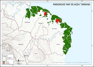
This study examines spatiotemporal changes in mangrove cover and canopy density in Aceh Tamiang Regency, Indonesia, between 2020 and 2024, using an integrated remote sensing and field-based approach. High-resolution PlanetScope imagery (3 m) and Sentinel-2A data (10 m) were analyzed within a GIS framework, with the Normalized Difference Vegetation Index (NDVI) employed to classify mangrove density into three categories: dense (NDVI ≥ 0.43), moderate (0.33 ≤ NDVI < 0.43), and sparse (NDVI < 0.33). Results reveal a net loss of 379.65 hectares of mangrove cover—declining from 10,796.76 ha in 2020 to 10,417.11 ha in 2024—with over 99% of deforestation occurring in production forest zones, primarily due to conversion for aquaculture and oil palm plantations. Concurrently, dense mangrove areas decreased by 2,226 hectares (–18.9%), while sparse mangrove coverage expanded by 1,542 hectares (+28.1%), signaling ecosystem degradation despite localized natural regeneration. These structural changes undermine critical ecological functions, including coastal protection, blue carbon storage, and habitat provision for species such as Batagur borneoensis. The findings underscore the urgent need to integrate satellite-derived monitoring into district-level spatial planning, prioritize community-based rehabilitation in transitional zones, and strengthen enforcement of mangrove protection under Indonesia’s Government Regulation No. 27 of 2025 to ensure long-term coastal resilience.
Downloads
References
Alongi, Daniel M. (2012a). Carbon sequestration in mangrove forests. In Carbon Management Vol. 3, Numéro 3.
Barbier, Edward B. ; Hacker, Sally D. ; Kennedy, Chris ; Koch, Evamaria W. ; Stier, Adrian C. et Silliman, Brian R. (2011). The value of estuarine and coastal ecosystem services. In Ecological Monographs Vol. 81, Numéro 2.
Batagur borneoensis: Shepherd, C., Horne, B.D., Guntoro, J. & Cota, M. (2018). In IUCN Red List of Threatened Species.
Chandra, Yuliana Iik Iswanti ; Maryanto, Sukir ; Susilo, Adi ; Faridha Aprilia et Mayang Bunga Puspita. (2025). Deformation Of Lava Tounge at Semeru Volcano using Sentinel-1 DInSAR. Journal of Geoscience, Engineering, Environment, and Technology, 10(1), pp. 23 28.
Donato, Daniel C. ; Kauffman, J. Boone ; Murdiyarso, Daniel ; Kurnianto, Sofyan ; Stidham, Melanie et Kanninen, Markku. (2011). Mangroves among the most carbon-rich forests in the tropics. Nature Geoscience, 4(5), pp. 293 297.
Giri, C. ; Ochieng, E. ; Tieszen, L. L. ; Zhu, Z. ; Singh, A. ; Loveland, T. ; Masek, J. et Duke, N. (2011). Status and distribution of mangrove forests of the world using earth observation satellite data. Global Ecology and Biogeography, 20(1), pp. 154 159.
Hussain, Syed Ainul et Badola, Ruchi. (2010). Valuing mangrove benefits: Contribution of mangrove forests to local livelihoods in Bhitarkanika Conservation Area, East Coast of India. Wetlands Ecology and Management, 18(3), pp. 321 331.
Ilman, Muhammad ; Dargusch, Paul ; Dart, Peter et Onrizal. (2016a). A historical analysis of the drivers of loss and degradation of Indonesia’s mangroves. Land Use Policy, 54, pp. 448 459.
Kuenzer, Claudia ; Bluemel, Andrea ; Gebhardt, Steffen ; Quoc, Tuan Vo et Dech, Stefan. (2011). Remote sensing of mangrove ecosystems: A review. In Remote Sensing Vol. 3, Numéro 5.
Mastu, La Ode Khairum ; Nababan, Bisman et Panjaitan, James P. (2018). PEMETAAN HABITAT BENTIK BERBASIS OBJEK MENGGUNAKAN CITRA SENTINEL-2 DI PERAIRAN PULAU WANGI-WANGI KABUPATEN WAKATOBI. Jurnal Ilmu dan Teknologi Kelautan Tropis, 10(2), pp. 381 396.
Maulana, Ananda Satria ; Agus, Syamsul Bahri ; Panjaitan, James Parlindungan et Arifin, Taslim. (2026). Object-based mapping of shallow marine habitats using Sentinel-2A images on Rakit Island, Sumbawa Regency, West Nusa Tenggara. BIO Web of Conferences, 220.
Metananda, Arya A. ; Al-Reza, Dimaz D. ; Hanum, Cut M. et Afrianto, Whisnu F. (2025). Sustainability status of mangrove rehabilitation in Natuna Regency, Indonesia: A rapid appraisal using RAPFISH. Narra X, 3(3), pp. e248.
Murdiyarso, D ; Hergoualc’h, K et Verchot, L V. (s. d.-a). Opportunities for reducing greenhouse gas emissions in tropical peatlands.
Murdiyarso, D ; Hergoualc’h, K et Verchot, L V. (s. d.-b). Opportunities for reducing greenhouse gas emissions in tropical peatlands.
Richards, Daniel R. et Friess, Daniel A. (2016). Rates and drivers of mangrove deforestation in Southeast Asia, 2000-2012. Proceedings of the National Academy of Sciences of the United States of America, 113(2), pp. 344 349.
Rizki, Fajar ; Situmorang, Arini Dewi Lestari ; Wau, Nirwana ; Lubis, Muhammad Zainuddin et Anurogo, Wenang. (2017). Mapping Of Vegetation And Mangrove Distribution Level In Batam Island Using SPOT-5 Satellite Imagery. Journal of Geoscience, Engineering, Environment, and Technology, 2(4), pp. 264.
Saputra, S. ; Arisoesilaningsih, E. ; Kurniawan, N. et Retnaningdyah, C. (2021a). Evaluation of riparian vegetation diversity as a tuntong laut (Batagur borneoensis) habitat in River Tamiang, Aceh Tamiang, Aceh Province, Indonesia. IOP Conference Series: Earth and Environmental Science, 743(1).
Saputra, S. ; Arisoesilaningsih, E. ; Kurniawan, N. et Retnaningdyah, C. (2021b). Evaluation of riparian vegetation diversity as a tuntong laut (Batagur borneoensis) habitat in River Tamiang, Aceh Tamiang, Aceh Province, Indonesia. IOP Conference Series: Earth and Environmental Science, 743(1).
Usman Zakaria, Muhammad ; Widyatmanti, Wirastuti et Jatmiko, Retnadi Heru. (2025). Applied One-Dimensional Convolutional Neural Network Image Fusion Sentinel-1 SAR and Sentinel-2 for Classification and Mapping Dynamics of Coastal Wetlands in Segara Anakan, Cilacap Regency, Indonesia. Journal of Geoscience, Engineering, Environment, and Technology, 10, pp. 2025.
Wairara, Stenly M.B.S et Sianturi, Reny. (2019). Potential Regeneration of Mangrove Coastal of Payum Beach Merauke District. Musamus Fisheries and Marine Journal, pp. 11 23.
Downloads
Published
Issue
Section
License
Copyright (c) 2026 Journal of Geoscience, Engineering, Environment, and Technology

This work is licensed under a Creative Commons Attribution-ShareAlike 4.0 International License.
Copyright @2019. This is an open-access article distributed under the terms of the Creative Commons Attribution-ShareAlike 4.0 International License which permits unrestricted use, distribution, and reproduction in any medium. Copyrights of all materials published in JGEET are freely available without charge to users or / institution. Users are allowed to read, download, copy, distribute, search, or link to full-text articles in this journal without asking by giving appropriate credit, provide a link to the license, and indicate if changes were made. All of the remix, transform, or build upon the material must distribute the contributions under the same license as the original.


