
Applied One-Dimensional Convolutional Neural Network Image Fusion Sentinel-1 SAR and Sentinel-2 for Classification and Mapping Dynamics of Coastal Wetlands in Segara Anakan, Cilacap Regency, Indonesia
DOI:
https://doi.org/10.25299/jgeet.2025.10.4.22909Keywords:
Convolutional Neural Network, Wetland, Image Fusion, Mangrove, SARAbstract
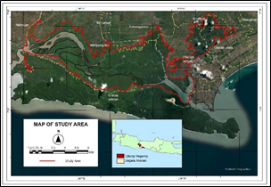
Coastal wetlands have an important function, namely as an economic function and an ecological function, therefore the mapping and classification of wetlands is very important. However, remote sensing has limitations, namely high variability and spectral similarity between kleas. This makes the development of image fusion of SAR and optical images in classification, the combination of SAR and optical can provide better information. Over time, the CNN method of performing image fusion developed, which is a good method used to perform classification. In this study, Sentinel-2 fusion and VV polarization were used to identify the shrub classes that dominate Segara Anakan. The results of the application of CNN1D in the classification of wetlands in Segara Anakan resulted in an overall accuracy of 79.37% and a kappa of 0.76, so that CNN1D is very good at recognizing wetland classes but has limitations in recognizing Nypa which has spectral similarities with other classes. The benefit of using CNN1D that has been trained is that the model can be applied to a variety of other images. In its application, we used the image of Segara Anakan from 2019-2025 so as to gain knowledge, namely that Segara Anakan is controlled by the sedimentation process so that wetland classes increase dynamically. The massive sedimentation process in Segara Anakan was then overgrown by mangrove vegetation, besides that another trend is the change of vegetation from mangroves to nypa vegetation. This is because nypa vegetation is a vegetation that can adapt to medium to low salinity. Despite conducting a multitemporal study with a narrow gap of 6 years, the CNN1D that we have trained can classify wetlands in Segara Anakan well from 2019 to 2025. In addition, CNN1D with a light computing load can be an option if you need deep learning applications in other research.
Downloads
References
Al-Maliki, S., Ibrahim, T.I.M., Jakab, G., Masoudi, M., Makki, J.S., Vekerdy, Z., 2022. An Approach for Monitoring and Classifying Marshlands Using Multispectral Remote Sensing Imagery in Arid and Semi-Arid Regions. Water (Switzerland) 14.
Anrozi, R., Siagian, A., Restisha, V.A., Maretta, A., 2019. Biodiversity Study on Segara Anakan Lagoon. IOP Conf. Ser. Earth Environ. Sci. 298.
Costa, M.P.D.F., De Moraes Novo, E.M.L., Mitsuo, F., Mantovani, J.E., Ahern, F., Ballester, M. V., Pietsch, R.W., 1998. The amazon floodplain through radar eyes: Lago grande de monte alegre case study. Can. J. Remote Sens. 24, 339–349.
DeLancey, E.R., Simms, J.F., Mahdianpari, M., Brisco, B., Mahoney, C., Kariyeva, J., 2020. Comparing deep learning and shallow learning for large-scalewetland classification in Alberta, Canada. Remote Sens. 12.
Djohan, T.S., 2015. Colonization of Mangrove Forest At Abandoned Shrimp-Pond of Segara Anakan-Cilacap. J. Teknosains 4.
Dorado-Rojas, S.A., Xu, S., Vanfretti, L., Ayachi, M.I.I., Ahmed, S., 2022. ML-Based Edge Application for Detection of Forced Oscillations in Power Grids. IEEE Power Energy Soc. Gen. Meet. 2022-July.
Fei, J., Zhang, X., Li, C., Hao, F., Guo, Y., Fu, Y., 2025. A deep data fusion-based reconstruction of water index time series for intermittent rivers and ephemeral streams monitoring. ISPRS J. Photogramm. Remote Sens. 220, 339–353.
Finlayson, M., Cruz, R.D., Davidson, N., Alder, J., Cork, S., Groot, R.S. de, Lévêque, C., Milton, G.R., Peterson, G., Pritchard, D., Ratner, B.D., Reid, W.V., Revenga, C., Rivera, M., Schutyser, F., Siebentritt, M., Stuip, M., Tharme, R., Butchard, S., 2005. Ecosystems and human well-being: wetlands and water synthesis. Millennium ecosystem assessment report to the ramsar convention, Millennium Ecosystem Assesment World Resources Institute, Washington, DC.
Habibie, M.I., Ramadhan, Nurda, N., Sencaki, D.B., Putra, P.K., Prayogi, H., Agustan, Sutrisno, D., Bintoro, O.B., 2024. The development land utilization and cover of the Jambi district are examined and forecasted using Google Earth Engine and CNN1D. Remote Sens. Appl. Soc. Environ. 34, 101175.
Henderson, F.M., Lewis, A.J., 2008. Radar detection of wetland ecosystems: A review. Int. J. Remote Sens. 29, 5809–5835.
Holtermann, P., Burchard, H., Jennerjahn, T., 2009. Hydrodynamics of the Segara Anakan lagoon. Reg. Environ. Chang. 9, 245–258.
Jafarzadeh, H., Mahdianpari, M., Gill, E.W., 2022. Wet-GC: A Novel Multimodel Graph Convolutional Approach for Wetland Classification Using Sentinel-1 and 2 Imagery With Limited Training Samples. IEEE J. Sel. Top. Appl. Earth Obs. Remote Sens. 15, 5303–5316.
Jamali, A., Mahdianpari, M., Mohammadimanesh, F., Homayouni, S., 2022. A deep learning framework based on generative adversarial networks and vision transformer for complex wetland classification using limited training samples. Int. J. Appl. Earth Obs. Geoinf. 115, 103095.
Liu, J., Li, P., Tu, C., Wang, H., Zhou, Z., Feng, Z., Shen, F., Li, Z., 2022. Spatiotemporal Change Detection of Coastal Wetlands Using Multi-Band SAR Coherence and Synergetic Classification. Remote Sens. 14.
Marzuki, Arjasakusuma, S., Khakhim, N., Wicaksono, P., Farda, N.M., Utami, N.L.E., 2025. Spectral-Spatial Deep Learning model for seaweed cultivation mapping using PlanetScope imagery in Pangkajene and Islands Regency. Marit. Technol. Res. 7.
Nogueira, K., Penatti, O.A.B., dos Santos, J.A., 2017. Towards better exploiting convolutional neural networks for remote sensing scene classification. Pattern Recognit.
Prayudha, B., Ulumuddin, Y.I., Siregar, V., Suyarso, Agus, S.B., Prasetyo, L.B., Suyadi, Avianto, P., Ramadhani, M.R., 2024. Enhanced mangrove index: A spectral index for discrimination understorey, nypa, and mangrove trees.
Ramsar Convention Secretariat, 2010. Designating Ramsar Sites: Strategic Framework and guidelines for the future development of the List of Wetlands of International Importance. Ramsar handbooks wise use Wetl. 17, 616.
Ramsey, E.W., Nelson, G.A., Sapkota, S.K., Laine, S.C., Verdi, J., Rrasznay, S., 1999. Using multiple-polarization L-band radar to monitor marsh burn recovery. IEEE Trans. Geosci. Remote Sens. 37, 635–639.
Reiche, J., Verbesselt, J., Hoekman, D., Herold, M., 2015. Fusing Landsat and SAR time series to detect deforestation in the tropics. Remote Sens. Environ.
Rezaee, M., Mahdianpari, M., Zhang, Y., Salehi, B., 2018. Deep Convolutional Neural Network for Complex Wetland Classification Using Optical Remote Sensing Imagery. IEEE J. Sel. Top. Appl. Earth Obs. Remote Sens. 11, 3030–3039.
Semeniuk, C.., Semeniuk, V., 1995. A Geomorphic Approach to Global Classification for Inland Wetlands 118, 103–124.
Shao, Z., Cai, J., 2018. Remote Sensing Image Fusion with Deep Convolutional Neural Network. IEEE J. Sel. Top. Appl. Earth Obs. Remote Sens. 11, 1656–1669.
Singh, Simrandeep, Singh, H., Bueno, G., Deniz, O., Singh, Sartajvir, Monga, H., Hrisheekesha, P.N., Pedraza, A., 2023. A review of image fusion: Methods, applications and performance metrics. Digit. Signal Process. A Rev. J. 137, 104020.
Tiner, R.W., Lang, M.W., Klemas, V. V., 2015. Remote Sensing of Wetlands Aplication and Advances, Remote Sensing of Wetlands: Applications and Advances. CRC Press, Boca Raton. Wetlands International Indonesia, 2022. Lahan Basah untuk Manusia dan Alam. Bogor.
Winarso, G., Rosid, M.S., Kamal, M., Asriningrum, W., Margules, C., Supriatna, J., 2023. Comparison of Mangrove Index (MI) and Normalized Difference Vegetation Index (NDVI) for the detection of degraded mangroves in Alas Purwo Banyuwangi and Segara Anakan Cilacap, Indonesia. Ecol. Eng. 197.
Yang, Y., Zhang, Y., Cheng, Y., Lei, Z., Gao, X., Huang, Y., Ma, Y., 2023. Using one-dimensional convolutional neural networks and data augmentation to predict thermal production in geothermal fields. J. Clean. Prod. 387, 135879.
Zeng, Y., Zhang, Y.X., Van Genderen, J.L., 2006. Comparison and Analysis of Remote Sensing Data Fusion Techniques. Proc. ISPRS Comm. VII Symp. ’Remote Sens. From Pixels to Process. 36, 5.
Zhang, R., Tang, X., You, S., Duan, K., Xiang, H., Luo, H., 2020. A novel feature-level fusion framework using optical and SAR remote sensing images for land use/land cover (LULC) classification in cloudy mountainous area. Appl. Sci. 10, 1–24.
Zhao, X., Hong, D., Gao, L., Zhang, B., Chanussot, J., 2021. Transferable deep learning from time series of landsat data for national land-cover mapping with noisy labels: A case study of China. Remote Sens. 13.
Zhou, L., Zhang, Y., Hu, Z., Yu, Z., Luo, Y., Lei, Y., Lei, H., Lei, Z., Ma, Y., 2019. Analysis of influencing factors of the production performance of an enhanced geothermal system (EGS) with numerical simulation and artificial neural network (ANN). Energy Build. 200, 31–46.
Zoran, L.F., 2009. Quality evaluation of multiresolution remote sensing images fusion. UPB Sci. Bull. Ser. C Electr. Eng. 71, 37–52.
Downloads
Published
Issue
Section
License
Copyright (c) 2025 Journal of Geoscience, Engineering, Environment, and Technology

This work is licensed under a Creative Commons Attribution-ShareAlike 4.0 International License.
Copyright @2019. This is an open-access article distributed under the terms of the Creative Commons Attribution-ShareAlike 4.0 International License which permits unrestricted use, distribution, and reproduction in any medium. Copyrights of all materials published in JGEET are freely available without charge to users or / institution. Users are allowed to read, download, copy, distribute, search, or link to full-text articles in this journal without asking by giving appropriate credit, provide a link to the license, and indicate if changes were made. All of the remix, transform, or build upon the material must distribute the contributions under the same license as the original.


