
Exploratory of Ecological Quality from Remote-Sensing Ecological Index and Drought Hazard in Pekalongan Regency, Indonesia
DOI:
https://doi.org/10.25299/jgeet.2025.10.3.22396Keywords:
RSEI, Ecological quality, Remote sensing, Drought hazard, Chi-square, Climate changeAbstract
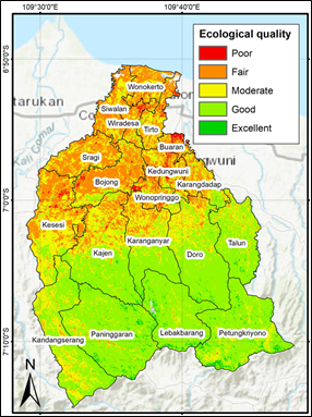
Climate change has intensified environmental hazards, including floods, landslides, and droughts, with Pekalongan Regency, Indonesia, emerging as a vulnerable region facing these multifaceted challenges. While flood-related studies dominate existing study, drought impacts remain understudied, despite their growing prevalence. Current climate hazard assessments in Pekalongan's adaptation plans rely heavily on historical data, limiting their predictive accuracy. This study addresses these gaps by developing a Remote Sensing Ecological Index (RSEI) model to evaluate ecological quality and its association with drought hazards, aligning with climate-resilient development objectives. The study employs Landsat imagery to construct RSEI using four key indicators: NDVI (greenness), WET (wetness), NDBSI (dryness), and LST (heat). Drought hazard data were derived from 2023 disaster records provided by Pekalongan's Regional Disaster Management Agency (BPBD). Statistical analysis using chi-square tests examined the relationship between RSEI components and drought hazard classes.Results demonstrate that RSEI's first principal component (PC1) effectively captures spatial ecological patterns, with southern regions (notably Petungkriyono's tropical rainforest) exhibiting "good" to "excellent" conditions, while northern urbanized areas score lower ("fair" to "poor"). PC1 shows a statistically significant association with drought hazard, unlike PC2 or PC3, suggesting its utility as a drought vulnerability indicator. However, the chi-square approach only identifies categorical relationships without quantifying effect strength or direction, highlighting methodological limitations.
This study contributes to climate adaptation science by validating RSEI's applicability for drought assessment in tropical coastal regions. Future study should incorporate ordinal regression or spatial modeling to enhance predictive capability. The findings support evidence-based policymaking for targeted mitigation in Pekalongan Regency and similar vulnerable regions, emphasizing the integration of ecological monitoring into climate adaptation frameworks.
Downloads
References
Adamopoulos, I., Frantzana, A., Syrou, N., 2024. Climate Crises Associated with Epidemiological, Environmental, and Ecosystem Effects of a Storm: Flooding, Landslides, and Damage to Urban and Rural Areas (Extreme Weather Events of Storm Daniel in Thessaly, Greece), in: Medical Sciences Forum. MDPI, p. 7.
Alganci, U., 2019. Dynamic land cover mapping of urbanized cities with Landsat 8 multi-temporal images: Comparative evaluation of classification algorithms and dimension reduction methods. ISPRS Int. J. geo-information 8, 139.
Ambarwati, N., Hastuti, D., Faida, L.R.W., 2023. Carrying Capacity Based on Ecosystem Services for Biodiversity Conservation in the Petungkriyono Essential Ecosystem Area Candidate. J. Ilmu Kehutan. 17, 96–105.
Aristiana, A., 2023. Musim kemarau diprediksi hingga awal oktober. Portal Kabupaten Pekalongan.
BAPPEDA Provinsi Jawa Tengah, 2023. Rencana Aksi Daerah Adaptasi Perubahan Iklim Provinsi Jawa Tengah. Semarang.
BAPPENAS, 2021. Kebijakan Pembangunan Berketahanan Iklim (Climate Resilience Development Policy) 2020–2045.
Bariadi, L., Saepuloh, A., 2025. Quantifying hydrothermal alteration Derived by remote sensing technique in Tompaso Geothermal Field (North Sulawesi Indonesia). J. Geosci. Eng. Environ. Technol. 10.
Bhowmik, S., Bhatt, B., 2024. Drought monitoring using modis derived indices and google earth engine platform for Vadodara District, Gujarat. J. Indian Soc. Remote Sens. 52, 1885–1900.
Buchori, I., Zaki, A., Pangi, P., Sejati, A.W., Pramitasari, A., Liu, Y., 2022. Adaptation strategies and community participation in government-led mitigation projects: A comparison between urban and suburban communities in Pekalongan, Indonesia. Int. J. Disaster Risk Reduct. 81, 103271.
Chen, N., Cheng, G., Yang, J., Ding, H., He, S., 2023. Evaluation of urban ecological environment quality based on improved RSEI and driving factors analysis. Sustainability.
Dzakiyah, I.F., Saraswati, R., 2020. Drought area of agricultural land using Tasseled Cap Transformation (TCT) method in Ciampel Subdistrict Karawang Regency, in: E3S Web of Conferences. EDP Sciences, p. 2005.
Fariz, T.R., Faniza, V., 2023. Comparison of built-up land indices for building density mapping in urban environments, in: AIP Conference Proceedings. AIP Publishing.
Fariz, T.R., Haris, A., Martuti, N.K.T., Eralita, N., Saputri, L.H., Syahbananto, G., Purwadi, C.E., Rafidah, Z., Az-Zahra, S., 2025. Comparison of Landsat 8 and Landsat 9 Satellite Imagery for Land Cover Mapping in the Kendal - Pekalongan Coastal Area Comparison of Landsat 8 and Landsat 9 Satellite Imagery for Land Cover Mapping in the Kendal - Pekalongan Coastal Area. IOP Conf. Ser. Earth Environ. Sci.
Fariz, T.R., Nugraha, F.A., Putra, G.A.Y., Nugroho, A.A., Salima, D.R., Pradiny, L.E., Faesal, A.M., 2022. Kajian Kapasitas Masyarakat Berbasis Aset Penghidupan Terhadap Bencana Kekeringan. LaGeografia 21, 31–42.
Fariz, T.R., Suhardono, S., Fadhilla, S., 2024. Rapid mapping of land cover changes in tropical watershed in Indonesia using Google Earth Engine, in: IOP Conference Series: Earth and Environmental Science. IOP Publishing, p. 12077.
Frame, D.J., Rosier, S.M., Noy, I., Harrington, L.J., Carey-Smith, T., Sparrow, S.N., Stone, D.A., Dean, S.M., 2020. Climate change attribution and the economic costs of extreme weather events: a study on damages from extreme rainfall and drought. Clim. Change 162, 781–797.
Gao, W., Zhang, S., Rao, X., Lin, X., Li, R., 2021. Landsat TM/OLI-based ecological and environmental quality survey of Yellow River Basin, Inner Mongolia Section. Remote Sens. 13, 4477.
Ghasempour, F., Sekertekin, A., Kutoglu, S.H., 2023. How Landsat 9 IS superior to Landsat 8: Comparative assessment of land use land cover classification and land surface temperature. ISPRS Ann. Photogramm. Remote Sens. Spat. Inf. Sci. 10, 221–227.
Gradiyanto, F., Parmantoro, P.N., 2025. Impact of climate change on Kupang River flow and hydrological extremes in Greater Pekalongan, Indonesia. Water Sci. Eng. 18, 69–77.
Hu, X., Xu, H., 2018. A new remote sensing index for assessing the spatial heterogeneity in urban ecological quality: A case from Fuzhou City, China. Ecol. Indic. 89, 11–21.
Islam, M.A., Jimmy, A.N., Alam, M.S., Khan, N.A., 2021. The use of multi-temporal Landsat normalized difference vegetation index (NDVI) data for assessing forest cover change of Lawarchara National Park. Environ. Dev. Sustain. 23, 17702–17722.
Li, N., Wang, J., Guo, J., 2023. The spatial differentiation and impact factor of eco-environment in Huai River Basin based on the improved RSEI model. Int. Conf.
Liu, Y., Zhou, T., Yu, W., 2024. Analysis of changes in ecological environment quality and influencing factors in Chongqing Based on a remote-sensing ecological index mode. Land.
Mardiansjah, F.H., Sugiri, A., Ma’rif, S., 2021. Examining small-town growth and expansion in peri-urban areas of small cities: Evidence from peripheries of three small cities in central java. J. Reg. city Plan. 32, 216–232.
Mistry, P., Suryanarayana, T.M.V., 2023. Assessment & Monitoring of Agricultural Drought Indices Using Remote Sensing Techniques and their Inter-Comparison. Ecol. Perspect. 3, 1–8.
Moustafa, A.A., Elganainy, R.A., Mansour, S.R., 2023. Insights into the UNSG announcement: The end of climate change and the arrival of the global boiling era, July 2023 confirmed as the hottest month recorded in the past 120,000 years. Catrina Int. J. Environ. Sci. 28, 43–51.
Muhaimin, M., Arisanty, D., Adyatma, S., Saputra, A.N., Jumriani, J., 2024. Utilization of Landsat 8 Oli Tirs for Environmental Quality Spatial Modeling, in: IOP Conference Series: Earth and Environmental Science. IOP Publishing, p. 12010.
Pratama, M.B., 2019. Tidal flood in Pekalongan: utilizing and operating open resources for modelling, in: IOP Conference Series: Materials Science and Engineering. IOP Publishing, p. 12029.
Riyatmoko, A., Sanjoto, T.B., 2022. Impact of the rob flood disaster in north pekalongan, in: IOP Conference Series: Earth and Environmental Science. IOP Publishing, p. 12016.
Sanjaya, S., Cantik, B.K.P., Wardaningrum, A.S., 2024. Analisis Derajat Bencana Kekeringan di Pulau Jawa Akibat Fenomena El-Nino 2023. J. Tek. Sumber Daya Air 115–126.
Sarah, D., Soebowo, E., Satriyo, N.A., 2021. Review of the land subsidence hazard in pekalongan delta, central java: Insights from the subsurface. Rud. Zb. 36.
Sekertekin, A., Bonafoni, S., 2020. Land surface temperature retrieval from Landsat 5, 7, and 8 over rural areas: Assessment of different retrieval algorithms and emissivity models and toolbox implementation. Remote Sens. 12, 294.
Serban, C., Maftei, C., 2025. Remote Sensing Evaluation of Drought Effects on Crop Yields Across Dobrogea, Romania, Using Vegetation Health Index (VHI). Agriculture 15, 668.
Setiawan, T.A., Ilyas, A., Binabar, S.W., 2020. Pemetaan Potensi Pariwisata Petungkriyono Berbasis Web Geographycal Information System (GIS) sebagai Cultural Techno Forestry Park Kabupaten Pekalongan. IC-Tech 15.
Sholihah, R.I., Trisasongko, B.H., Shiddiq, D., La Ode, S.I., Kusdaryanto, S., Panuju, D.R., 2016. Identification of agricultural drought extent based on vegetation health indices of landsat data: case of Subang and Karawang, Indonesia. Procedia Environ. Sci. 33, 14–20.
Sidiq, W.A.B.N., Fariz, T.R., Saputro, P.A., Sholeh, M., 2024. Risk Screening Environmental Indicators Model Change Based on Spectral Transformation Around New Yogyakarta International Airport. Ecol. Eng. Environ. Technol. 25.
Sidiq, W.A.B.N., Sanjoto, T.B., Jabbar, A., 2025. Assessing Environmental Quality Using the Risk Screening Environmental Indicators (RSEI) Method: A Multi-Year Remote Sensing Approach. Adv. Sustain. Sci. Eng. Technol. 7.
Ula, M.N., Tijan, T., 2020. Implementasi Kebijakan Penanggulangan Rob di Kabupaten Pekalongan. Unnes Polit. Sci. J. 4, 21–26.
Wahyuddin, Y., Fernanda, A.R., Sabri, L.M., Ammarohman, F.J., 2023. Instrumenting GIS as smart city tools to identify the impact of tidal flood threat in the Coastal Zone of Pekalongan City. Env. Ecol Res 11, 328–339.
Woelansari, M., Maryono, M., Muhammad, F., Halim, M.A.R., Setyawan, A., 2020. Community participation in conservation of petungkriyono protected areas in pekalongan district, in: E3S Web of Conferences. EDP Sciences, p. 6002.
Xiong, Q., Hong, Q., Chen, W., 2024. Temporal and spatial response of ecological environmental quality to land use transfer in Nanling Mountain region, China based on RSEI: A case study of Longnan …. Land.
Xu, S., Jin, X., 2024. Ecological environment quality evaluation and its influencing factors in yuecheng district based on remote sensing ecological index. Environ. Dev. Sustain.
Yan, X., Li, Jing, Yang, D., Li, Jiwei, Ma, T., Su, Y., Shao, J., Zhang, R., 2022. A random forest algorithm for landsat image chromatic aberration restoration based on GEE cloud platform—a case study of yucatán peninsula, Mexico. Remote Sens. 14, 5154.
Zhang, X., Jia, W., Lu, S., He, J., 2024. Ecological assessment and driver analysis of high vegetation cover areas based on new remote sensing index. Ecol. Inform.
Zheng, Z., Wu, Z., Chen, Y., Guo, C., Marinello, F., 2022. Instability of remote sensing based ecological index (RSEI) and its improvement for time series analysis. Sci.
Downloads
Published
Issue
Section
License
Copyright (c) 2025 Journal of Geoscience, Engineering, Environment, and Technology

This work is licensed under a Creative Commons Attribution-ShareAlike 4.0 International License.
Copyright @2019. This is an open-access article distributed under the terms of the Creative Commons Attribution-ShareAlike 4.0 International License which permits unrestricted use, distribution, and reproduction in any medium. Copyrights of all materials published in JGEET are freely available without charge to users or / institution. Users are allowed to read, download, copy, distribute, search, or link to full-text articles in this journal without asking by giving appropriate credit, provide a link to the license, and indicate if changes were made. All of the remix, transform, or build upon the material must distribute the contributions under the same license as the original.


