
Application of DRASTIC Method for Groundwater Vulnerability Analysis to Contamination in Pemalang District, Pemalang Regency, Central Java Province, Indonesia
DOI:
https://doi.org/10.25299/jgeet.2025.10.02.22209Keywords:
DRASTIC, Groundwater, Pemalang, VulnerabilityAbstract
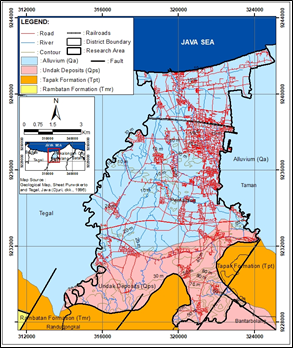
Pemalang District, Pemalang Regency, Central Java Province, as the district's capital, has experienced rapid economic and population growth. This has resulted in increased exploitation and degradation of groundwater quality, with groundwater extraction increasing from 91,856 m³ to 133,708 m³. There was an average decrease in groundwater levels of 40-70 cm from 2020 to 2023, and an increase in nitrate and chloride levels in groundwater was recorded from 2021 to 2023. To maintain the availability of groundwater that is suitable for use, efforts are needed to prevent groundwater contamination in vulnerable areas. The approach applied to examine groundwater vulnerability to contamination is the DRASTIC method. The research location is a coastal area composed of quaternary deposits with lithology consisting of sand and gravel in the south and clay and silt in the north. It has a shallow groundwater depth and a groundwater flow pattern that flows from south to north. The results of the geospatial analysis revealed two zones of groundwater vulnerability to contamination, based on the DRASTIC Index value, consisting of moderate vulnerability (>106-146) and high vulnerability (>146-186). There were 67.4% of high vulnerability zones in this research area, spread from the central part, which is Wanamulya Village, to the southern part, which is Surajaya Village.
Downloads
References
Abdeslam, I., Fehdi, C., Djabri, L., 2017. Application of drastic method for determining the vulnerability of an alluvial aquifer: Morsott - El Aouinet north east of Algeria: using arcgis environment. Int. Conf. Technol. Mater. Renew. Energy Environ. Sustain. TMREES17 21-24 April 2017 Beirut Leban. 119, 308–317.
Aller, L., Bennett, T., Lehr, J.H., Petty, R.J., 1985. DRASTIC: A Standardized System for Evaluation Groundwater Pollution Potential Using Hydrogeologic Settings. U.S. Environmental Protection Agency, Oklahoma.
Aribowo, K., 2021. Kerentanan Air Tanah Terhadap Pencemaran di Kecamatan Muntilan, Salam dan Ngluwar Kabupaten Magelang, Provinsi Jawa Tengah. Gadjah Mada University, Yogyakarta.
Barbulescu, A., 2020. Assessing Groundwater Vulnerability: DRASTIC and DRASTIC-Like Methods: A Review. Water J., MDPI 22.
Central Statistics Agency of Pemalang Regency, 2023. Pemalang Regency in Figures. Central Statistics Agency of Pemalang Regency, Pemalang.
Department of Energy and Mineral Resources of Central Java Province, 2023. Annual Report of the Energy and Mineral Resources Service of Central Java Province 2023. Department of Energy and Mineral Resources of Central Java Province, Semarang.
Department of Public Works and Spatial Planning of Pemalang Regency, 2023. Annual Report of the Department of Public Works and Spatial Planning of Pemalang Regency. Pemalang.
Djuri, M., Samodra, H., Amin, T.C., Gafoer, S., 1996. Geological Map Sheet Purwokerto and Tegal.
Effendi, A.T., 1985. Hydrogeological Map of Indonesia Pekalongan Sheet (Java).
Huan, H., Wang, J., Teng, Y., 2012. Assessment and validation of groundwater vulnerability to nitrate based on a modified DRASTIC model: A case study in Jilin City of northeast China. Integr. Model. Monit. Differ. River Basin Scales Glob. Change 440, 14–23.
Linggasari, S., Chayadi, T.A., Ernawati, T., 2019. Overview Metode Perhitungan Kerentanan Air Tanah Terhadap Rencana Penambangan. Presented at the Nasional Rekayasa Teknomogi Industri dan Informasi, pp. 123–219.
Listiawan, Y., Virgianty, A.S., Pramudyo, T., Iskandarsyah, Y.W.M., 2024. Groundwater Characteristics Analysis to Identify the Seawater Intrusion in Coastal Deep Aquifer System, Semarang, Central Java, Indonesia. J. Geosci. Eng. Environ. T
Morris, B., Foster, S., 2000. Assessment of Groundwater Pollution Risk.
Morris, B.L., Chilton, P.J.C., Adams, B., Calow, R.C., Klinck, B.A., 2003. Groundwater and its susceptibility to degradation: a global assessment of the problem and options for management, Eary warning and assessment report. UNEP, Nairobi, Kenya.
Ondara, K., Dhiauddin, R., Wisha, U.J., Rahmawan, G.A., 2020. Hydrodynamics Features and Coastal Vulnerability of Sayung Sub-District, Demak, Central Java, Indonesia. J. Geosci. Eng. Environ. Technol. 5 No 1.
Putra, D.P.E., 2007. The Impact of Urbanization on Groundwater Quality, A Case Study in Yogyakarta City–Indonesia, Mitteilungen zur Ingenieurgeologie und Hydrogeologie, Heft 96, 148 S, Okt 2007, Herausgegeben vom Lehrstuhl fuer Ingenieurgeologie und Hydrogeologie, RWTH Aachen, Germany, 2007.
Putranto, T.T., Ali, R.K., Putro, A.B., 2019. Studi Kerentanan Airtanah Terhadap Pencemaran Dengan Menggunakan Metode Drastic Pada Cekungan Airtanah (CAT) Karanganyar-Boyolali, Provinsi Jawa Tengah. J. Ilmu Lingkung. 17, 159.
Putranto, T.T., Widiarso, D.A., Yuslihanu, F., 2016. Studi Kerentanan Air Tanah Terhadap Kontaminan Menggunakan Metode Drastic di Kota Pekalongan. Teknik 37, 26.
Rachman M.H., Wilopo, W., Putra, D.P.E., 2022. Groundwater Vulnerability Assessment Using Simple Vertical Vulnerability Method In Wonosari, Gunungkidul, Yogyakarta, Indonesia. Proceedings of the International Conference on Sustainable Environment, Agriculture and Tourism (ICOSEAT 2022), ICOSEAT 2022, Atlantis Press, pp. 632–642.
Saidi, S., Bouri, S., Anselme, B., Ben, H., 2012. Guideline for Groundwater Resource Management Using the GIS Tools in Arid to Semi Arid Climate Regions, in: Kumar, M. (Ed.), Problems, Perspectives and Challenges of Agricultural Water Management. InTech.
Utomo, K.S., 2011. Intrusi Air Laut di Kabupaten Pemalang. Jurnal Teknik Sipil Dan Perencanaan 13 No 2, 141–150.
Vrba, Zaporec, 1994. Guidebook on Mapping Groundwater Vulnerability International Association of Hydrogeologists.
Wilopo, W., Putra, D.P.E, Setiawan, H., Susatio, R., 2019, Groundwater flow patterns and hydrochemical facies of Kendal groundwater basin, Central Java Province, Indonesia, IOP Conf. Series: Earth and Environmental Science 361 (2019) 012002.
Yusti, U., Yoseph, B., Hidayat, H., Septio, G., 2025. Hydrogeochemical Characterization and Quality Assessment of Groundwater in Rumbai District, Pekanbaru: Implications for Sustainable Water Management. J. Geosci. Eng. Environ. Technol. 10 No 1.
Downloads
Published
Issue
Section
License
Copyright (c) 2025 Journal of Geoscience, Engineering, Environment, and Technology

This work is licensed under a Creative Commons Attribution-ShareAlike 4.0 International License.
Copyright @2019. This is an open-access article distributed under the terms of the Creative Commons Attribution-ShareAlike 4.0 International License which permits unrestricted use, distribution, and reproduction in any medium. Copyrights of all materials published in JGEET are freely available without charge to users or / institution. Users are allowed to read, download, copy, distribute, search, or link to full-text articles in this journal without asking by giving appropriate credit, provide a link to the license, and indicate if changes were made. All of the remix, transform, or build upon the material must distribute the contributions under the same license as the original.


