Estimation Top and Bottom of Bogor Fault, Kepahiang Regency Based on 2D Magnetotelluric Data Analysis
DOI:
https://doi.org/10.25299/jgeet.2025.10.3.21168Keywords:
Faults, Kepahiang, Magnetotelluric, ResistivityAbstract
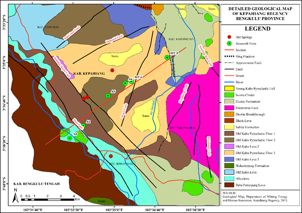
Kepahiang Regency, Bengkulu Province, is an area crossed by the Musi segment of the Sumatra Fault and a number of secondary faults, including the Bogor Fault, which contribute to the high level of seismic activity in the region. The presence of these active faults, combined with a relatively high population density, poses a potential threat to infrastructure and public safety. This study aims to identify the subsurface geometric characteristics of the Bogor Fault, particularly its upper and lower depths, as part of earthquake disaster mitigation efforts. The Magnetotelluric (MT) method was used in this survey with the ADU-07e system, which utilizes natural electromagnetic fields, with two horizontal electrical sensors (Ex, Ey) and three horizontal sensors (Hx, Hy), as well as a vertical magnetic sensor (Hz). Data collection was conducted at six measurement points with a 1 km interval along the Northeast–Southwest transect that crosses the Musi Fault and the Bogor Fault. Data processing was performed using MAPROS software for time-domain to frequency-domain conversion, and ZONDMT2D for subsurface modeling. The modeling results showed a low resistivity zone at point T6, with values between 0.21–1.6 Ωm, which was interpreted as the presence of the Bogor Fault. This zone was identified at a depth of approximately 2 km and was estimated to extend more than 8 km in the north–south direction. This finding provides important indications of the presence of an active fault in the area and can serve as a basis for earthquake risk mitigation efforts in Kepahiang.
Downloads
References
Al Ansory, A. R., Hana Raihana, Pritama, V. L., Saputri, W., Maghribi, F. B., Muchammad Farid, Arif Ismul Hadi, Halauddin, Harlianto, B., & Sugianto, N. (2023) ‘Delineasi Nilai Resistivitas Di Lapangan Panas Bumi Tambang Sawah Menggunakan Metode Magnetotellurik’, Buletin Sumber Daya Geologi, 18(3), pp. 145–154.
Ardiansyah, S. (2014) ‘Energi Potensial Gempabumi di Kawasan Segmen Mentawai-Sumatera Barat’, Psj, 2(1), pp. 45–49.
Ardiansyah, S. (2017) ‘Analisis Gempa Bumi Signifikan Segmen Musi’, Buletin Artikel Ilmiah MKKUG, 4(156), p. 1.
Firdaus, M.W., Setyawan, A. and Yusuf, M. (2016) ‘Identifikasi Letak dan Jenis Sesar Berdasarkan Metode Gayaberat Second Vertical Gradient Studi Kasus Sesar Lembang, Kota Bandung, Jawa Barat’, Youngster Physics Journal, 5(1), pp. 21–26.
Fitrida, S. M., Sampurno, J., Ivansyah, O., & Kholid, M. (2015) ‘Identifikasi Struktur Bawah Permukaan Berdasarkan Metode Magnetotellurik di Kawasan Panas Bumi Wapsalit Kabupaten Buru Provinsi Maluku’, Positron, 5(1), pp. 11–18.
Fitzpatrick, R. (2008) Maxwell’s Equations and The Principles of Electromagnetism.
Gafoer, S., Amin, T. and Pardede (2007) ‘Peta Geologi Segiempat Bengkulu, Sumatera ; Departemen Pertambangan dan Energi, Direktorat Jenderal Geologi dan Sumber Daya Mineral, Pusat Penelitian dan Pengembangan Geologi: Bandung, Indonesia’.
Hidayat, A.R., Junursyah, L.G.. and Asep, H. (2016) ‘Analisis Deret Waktu Untuk Peningkatan Kualitas Data Magnetotelurik (Studi Kasus Lapangan Geothermal)’, Proseding Seminar Nasional Fisika dan Aplikasinya, (November), pp. 1–10.
Irwanto, H., Jaya, D., Miansyah, A., Septiawan, A., Girsang, R. (2013) ‘Laporan Akhir Inventarisasi Mineral dan Batuan Tahun Anggaran 2013 ; Dinas Pertambangan Energi dan Sumber Daya Mineral Kabupaten Kepahiang: Kepahiang, Indonesia’.
Jasmine, K., Gaffar, E. Z., Zulaikah, Siti., P, Nugroho, A. (2014) ‘Penentuan Struktur Litologi Daerah Panasbumi Probolinggo Menggunakan Metode Magnetotellurik (MT)’, Penambahan Natrium Benzoat Dan Kalium Sorbat (Antiinversi) Dan Kecepatan Pengadukan Sebagai Upaya Penghambatan Reaksi Inversi Pada Nira Tebu [Preprint].
Kurniawan, T. and Rasmid (2016) ‘Seismic Gap di Sesar Geser Sumatera’, Megasains, 7(1), pp. 19–24.
Lestari, W., Widodo, A., Warnana, D. D., Syaifuddin, F., Rochman, J. P. G. N., Zarkasyi, A., & Setiawan, N. S. (2020) ‘Active Fault Delineation Using Magnetotelluric Data in the Western Region of East Java’, IOP Conference Series: Earth and Environmental Science, 506(1).
Lubis, A. M., Butarbutar, D. C., Suhendra, & Samdara, R. (2019) ‘Investigasi Sudut Pergerakan Sesar di Musi Kepahiang dengan Menggunakan Metode Geolistrik’, Jurnal Meteorologi dan Geofisika, 20(2), pp. 67–72.
Manyoe, I.N. (2018) ‘Model Inversi Data Geolitrik Untuk Penentuan Lapisan Bawah Permukaan Daerah Panas Bumi Bongongoayu, Gorontalo’, (June).
Mulyana, B. (2006) ‘Extension tektonik Selat Sunda’, Bulletin of Scientific Contribution, 4(2), pp. 137–145.
Natawaidjaja, D.H. and Triyoso, W. (2007) ‘the Sumatran Fault Zone — From Source To Hazard’, Journal of Earthquake and Tsunami, 01(01), pp. 21–47.
Nidya, Ferra., Suharno., Zarkasyi, Ahmad., Sugianto, Asep. (2013) ‘Analisis Karakteristik Panasbumi Daerah
Outflow Gunung Arjuno-Welirang Berdasarkan Data Geologi , Geokimia , Dan Geofisika ( 3G )’, Jurnal Geofisika Eksplorasi, 1(2), p. 7.
Pratama, Rikaldo., Resta, Ichy Lucya., Farid, Faizar., Joni, Wiwid. (2021) ‘Identifikasi Lapisan Bawah Permukaan Daerah Prospek Panas Bumi Songa-Wayaua Berdasarkan Metode Magnetotelurik’, Jurnal Meteorologi dan Geofisika, 22(2), p. 45.
PUSGEN. (2017). PETA SUMBER DAN BAHAYA GEMPA INDONESIA TAHUN 2017.
PUSGEN. (2022). PETA SUMBER DAN BAHAYA GEMPA INDONESIA TAHUN 2022.
Putri, D.I. (2023) Identifikasi Sesar Menggunakan Metode Gravitasi dan Penentuan Hiposenter Gempa Bumi dengan Metode Modified Joint Hypocenter Determination di Daerah Cianjur.
Rahmawati, N. I., Farid, M., Hadi, A. I., Rahmat, A., & Ansory, A. (2024) ‘Identification of Sub-Fault Zone Using Magnetotelluric Inversion ( Case Study : Ketaun Fault , Lemeu Village , Lebong Regency )’, 8(2), pp. 132–141.
Rizal, M., Ismail, N., Yanis, M., Muzakir, & Surbakti, M. S. (2019) ‘The 2D resistivity modelling on north sumatran fault structure by using magnetotelluric data’, IOP Conference Series: Earth and Environmental Science, 364(1).
Sakdiyah, K. and Choiruddin, A. (2021) ‘Model Inhomogeneous Log-Gaussian Cox Process (LGCP) untuk Pemetaan Risiko Gempa Bumi di Sumatra’, Jurnal Sains dan Seni ITS, 9(2), pp. 108–114.
Salam, R.A. and Harmoko, U. (2017) ‘Pemodelan 2D Sistem Pana Bumi Daerah Garut Bagian Timur Menggunakan Metode Magnetotelurik’, Youngster Physics Journal, 6(2), pp. 143–150.
Setyani, A.R.I. (2017) Investigasi bawah permukaan segmen cibeber zona sesar cimandiri, jawa barat dengan metode audio magnetotelurik (amt).
Sihombing, P. A., Hadi, A. I., Refrizon, R., & Zakariya, H. (2024) ‘Identification of the distribution of geothermal reservoirs around Kepahiang Bengkulu Province using GGMPlus gravity data anomalies by the 2D inversion method’, Journal of Aceh Physics Society, 13(1), pp. 1–8.
Supartoyo, Suntoko, H., Bondan, A., & Alhakim, E. E. (2019) ‘Analisis Morfotektonik dan Pemetaan Geologi pada Identifikasi Sesar Permukaan di daerah Plampang , Pulau’, Jurnal Pengembangan Energi Nuklir, 21(1), pp. 45–52.
Wote, J., Palilingan, R. N., Rende, J., Nusa, Jeilen G. N. (2023) ‘Analisis Karakteristik Tipe Fluida Mata Air Panas Di Hutan Pinus Lahendong Dengan Menggunakan Spektrofotometri’, Jurnal FisTa : Fisika dan Terapannya, 4(1), pp. 35–40.
Downloads
Published
Issue
Section
License
Copyright (c) 2025 Journal of Geoscience, Engineering, Environment, and Technology

This work is licensed under a Creative Commons Attribution-ShareAlike 4.0 International License.
Copyright @2019. This is an open-access article distributed under the terms of the Creative Commons Attribution-ShareAlike 4.0 International License which permits unrestricted use, distribution, and reproduction in any medium. Copyrights of all materials published in JGEET are freely available without charge to users or / institution. Users are allowed to read, download, copy, distribute, search, or link to full-text articles in this journal without asking by giving appropriate credit, provide a link to the license, and indicate if changes were made. All of the remix, transform, or build upon the material must distribute the contributions under the same license as the original.