
Geodiversity on the Great Sumatran Fault on Sungai Penuh Aspiring for the Geopark Designation, Jambi, Indonesia
DOI:
https://doi.org/10.25299/jgeet.2025.10.3.16610Keywords:
Aspiring, Geodiversity, Geopark, Great Sumatran Fault, Sungai PenuhAbstract
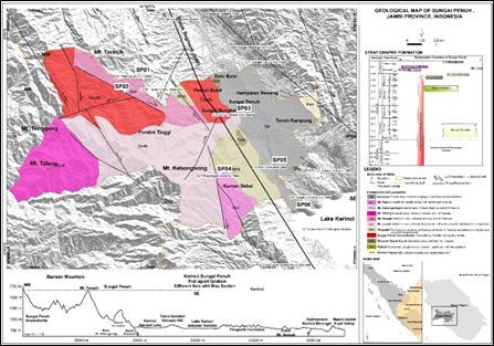
Sungai Penuh is a municipality in Jambi Province which is located in the westernmost part of the administrative region. Naturally, this region has natural beauty as a tourist attraction, where landscape on the Great Sumatran Fault in the Barisan Ranges Zone. The existence of faults plays an important role as the main actor that causes deformation of rocks and natural landscapes, so that it can produce geodiversity. Thus, conditions like this can be used as an important role in the presence of geodiversity for the identification of sustainable geotourism development. The aim of this study is to provide the latest information regarding the existence of the geodiversity in the Great Sumatran Fault for aspiring geopark designation. Research methods for conducting geodiversity features of lithology, stratigraphy, geological structure, and landscape. Then, qualitative assessment of geodiversity includes of education, scientific, and tourism of geodiversity site. Stratigraphically in the research area is composed of pyroclastic Bandan, Sheared Basalt, Sungai Penuh Granodiorite, pyroclastic Pengasih, andesitic lava and volcanic breccia of Mt. Lumut, andesitic lava and volcanic breccia of Mt. Tarasih, andesitic lava and volcanic breccia of Mt. Talang, andesitic lava and volcanic breccia of Mt. Kebongsong, andesitic to basaltic lava and volcanic breccia of Mt. Raya. It has geodiversity that can be used as a geotourism site such as Peak Depati VII Coffee, Dissected Mountains Granitoid Sungai Penuh, Ancient Lake Kerinci, Khayangan Volcanic Plateu, Sungai Penuh Cold Spring, Lake Volcano-tectonic Kerinci. These conditions provide demands for the geotourism loving community to preserve geological heritage in the concept of geological conservation to be proposed as a geological site in the geotourism aspect. So that this role can later have a positive impact on the local community around geotourism objects based on sustainable geotourism development aspiring geopark designation.
Downloads
References
Advokaat, E.L., Bongers, M.L.M., Rudyawan, A., BouDagher-Fadel, M.K., Langereis, C.G., van Hinsbergen, D.J.J., 2018. Early Cretaceous origin of the Woyla Arc (Sumatra, Indonesia) on the Australian plate. Earth Planet. Sci. Lett. 498, 348–361.
Aleksova, B., Lukić, T., Milevski, I., Puhar, D., Marković, S.B., 2024. Preliminary Assessment of Geohazards’ Impacts on Geodiversity in the Kratovska Reka Catchment (North Macedonia). Geosci. 14, 1–21.
Ansori, C., 2018. Geosite identification in Karangbolong High to support the development of Karangsambung-Karangbolong Geopark candidate, Central Java. IOP Conf. Ser. Earth Environ. Sci. 118.
Ansori, C., Kusworo, A., Mareta, N., Hastria, D., Putro, I.N.Y., 2024a. The True Mother Earth Geotrail, in Kebumen Geopark. IOP Conf. Ser. Earth Environ. Sci. 1424.
Ansori, C., Setiawan, N.I., Warmada, I.W., Yogaswara, H., 2022. Identification of geodiversity and evaluation of geosites to determine geopark themes of the Karangsambung-Karangbolong National Geopark, Kebumen, Indonesia. Int. J. Geoheritage Park. 10, 1–15.
Ansori, C., Warmada, I.W., Setiawan, N.I., Jogaswara, H., Fariji, M. Al, 2024b. The linkage of geological parameters to cultural diversity at Karangsambung-Karangbolong Geopark and surrounding area, Kebumen, Indonesia. Int. J. Geoheritage Park. 12, 168–179.
Ansori, C., Warmada, I.W., Setiawan, N.I., Yogaswara, H., 2023. Geospatial analysis of the distribution of the Megalithic to colonial cultural features at the Karangsambung-Karangbolong National Geopark, Kebumen, Indonesia and its surrounding area. Int. J. Geoheritage Park. 11, 407–432.
Ariani, R.P., Utama, H.W., 2023. Petrogenesis and Geological Structure of Tantan Granitoid in Sungai Manau District, Merangin Regency, Jambi Province. Eksplorium 43, 79.
Arias, C., de Vries, B.V.W., Aguilar, R., Mariño, J., Cueva, K., Manrique, N., Zavala, B., Ancalle, A., 2025. Volcanic geoheritage in Arequipa, Southern Peru: Assessment of pilot geosites for geohazard resilience. Int. J. Geoheritage Park. 13, 44–67.
Baillie, P., Fraser, T., Hall, R., Myers, K., 2003. Geological development of Eastern Indonesia and the northern Australia collision zone: a review. Proc. Timor Sea Symp. Darwin, North. Territ. Aust. June 19–10 539–550.
Barber, A.J., 2000. The origin of the Woyla Terranes in Sumatra and the late Mesozoic evolution of the Sundaland margin. J. Asian Earth Sci. 18, 713–738.
Barber, A.J., Crow, M.J., 2009. Structure of Sumatra and its implications for the tectonic assembly of Southeast Asia and the destruction of Paleotethys. Isl. Arc 18, 3–20.
Bellier, O., Sébrier, M., 1994. Relationship between tectonism and volcanism along the Great Sumatran Fault Zone deduced by spot image analyses. Tectonophysics 233, 215–231.
Bradley, K.E., Feng, L., Hill, E.M., Natawidjaja, D.H., Sieh, K., 2017. Implications of the diffuse deformation of the Indian Ocean lithosphere for slip partitioning of oblique plate convergence in Sumatra. J. Geophys. Res. Solid Earth 122, 572–591.
Brocx, M., Semeniuk, V., 2007. Geoheritage and geoconservation - history, definition, scope and scale. J. R. Soc. West. Aust. 90, 53–87.
Carrión-Mero, P., Sánchez-Zambrano, E., Mata-Perelló, J., Jaya-Montalvo, M., Herrera-Franco, G., Berrezueta, E., Espinel, R.L., Baque, M., Morante-Carballo, F., 2024. Geosites assessment in a volcanic hotspot environment and its impact on geotourism, Santa Cruz-Galapagos Islands, Ecuador. Int. J. Geoheritage Park. 12, 147–167.
Chlieh, M., Avouac, J.P., Sieh, K., Natawidjaja, D.H., Galetzka, J., 2008. Heterogeneous coupling of the Sumatran megathrust constrained by geodetic and paleogeodetic measurements. J. Geophys. Res. Solid Earth 113, 1–31.
Daryono, M.R., Hanif, M., Wardhana, D.D., Natawidjaja, D.H., 2023. Geological slip rate study on Renun Segment of Sumatran Fault in Dolok Sanggul area, North Sumatra using UAV photogrammetry and DEMNAS. IOP Conf. Ser. Earth Environ. Sci. 1227.
Gasparon, M., Varne, R., 1995. Sumatran granitoids and their relationship to Southeast Asian terranes. Tectonophysics 251, 277–299.
Gunawan, E., Sagiya, T., Ito, T., Kimata, F., Tabei, T., Ohta, Y., Meilano, I., Abidin, H.Z., Agustan, Nurdin, I., Sugiyanto, D., 2014. A comprehensive model of postseismic deformation of the 2004 Sumatra-Andaman earthquake deduced from GPS observations in northern Sumatra. J. Asian Earth Sci. 88, 218–229.
Hall, R., Breitfeld, H.T., 2017. Nature and demise of the Proto-South China Sea. Bull. Geol. Soc. Malaysia 63, 61–76.
Hennig, J., Breitfeld, H.T., Hall, R., Nugraha, A.M.S., 2017. The Mesozoic tectono-magmatic evolution at the Paleo-Pacific subduction zone in West Borneo. Gondwana Res. 48, 292–310.
Iqbal, M., Bella, D., Juliarka, R., 2019. Analisis Kerapatan Kelurusan (Lineament Density) sebagai indikator tingkat permeabilitas di Lapangan Panasbumi Suoh-Sekincau, Lampung. Orig. Artic. J. Sci. Appl. Technol. 3, 61–67.
Iqbal, P., Wibowo, D.A., Raharjo, P.D., Lestiana, H., Puswanto, E., 2023. the Great Sumatran Fault Depression At West Lampung District, Sumatra, Indonesia As Geomorphosite for Geohazard Tourism. Geoj. Tour. Geosites 47, 476–485.
Jarot, W., Hari, W.U., Muhammad, I.L., Yuliamorsa, S., Anggideliana, S., Juventa, Yosa, M., 2019. Characteristic of Geothermal System at Semurup Manifestation, Kerinci: Geological and Geochemistry Investigation-Based. IOP Conf. Ser. Earth Environ. Sci. 391, 0–10.
Kusnama, R. Pardede, S., Mangga, A., Sidarto, 1992. Geological Map of Sungai Penuh and Ketahun Quadrangle, Sumatra, Scale 1:250.000. Geological Research and Development Centre, Bandung, Indonesia.
Lange, D., Tilmann, F., Henstock, T., Rietbrock, A., Natawidjaja, D., Kopp, H., 2018. Structure of the central Sumatran subduction zone revealed by local earthquake travel-time tomography using an amphibious network. Solid Earth 9, 1035–1049.
Liu, Y., Zhang, J., 2022. Index establishment and capability evaluation of space-air-ground remote sensing cooperation in geohazard emergency response. Nat. Hazards Earth Syst. Sci. 22, 227–244.
Marliyani, G.I., Klinger, Y., Hady, A.K., Setianto, A., Helmi, H., Kurniawan, T., Kambali, R.A.P., Sugito, Z., Jihad, A., Setiawan, Y., Rusdin, A.A., Rohadi, S., Triyono, R., Karnawati, D., 2024. Exploring Aceh Fault Zone for Slip Rates and Paleoseismic Trenching Potential along Sumatran Fault. Indones. J. Geogr. 56, 138–148.
McCaffrey, R., 2009. The tectonic framework of the sumatran subduction zone. Annu. Rev. Earth Planet. Sci. 37, 345–366.
McCloskey, J., Antonioli, A., Piatanesi, A., Sieh, K., Steacy, S., Nalbant, S.S., Cocco, M., Giunchi, C., Huang, J.D., Dunlop, P., 2007. Near-field propagation of tsunamis from megathrust earthquakes. Geophys. Res. Lett. 34.
Metcalfe, I., 2017. Tectonic evolution of Sundaland. Bull. Geol. Soc. Malaysia 63, 27–60.
Metcalfe, I., 2013. Gondwana dispersion and Asian accretion: Tectonic and palaeogeographic evolution of eastern Tethys. J. Asian Earth Sci. 66, 1–33.
Metcalfe, I., 2011. Tectonic framework and Phanerozoic evolution of Sundaland. Gondwana Res. 19, 3–21.
Metcalfe, I., 1986. Late Palaeozoic palaeogeography of Southeast Asia: some stratigraphical, palaeontological and palaeomagnetic constraints. Bull. Geol. Soc. Malaysia 19, 153–164.
Muraoka, H., Takahashi, M., Sundhoro, H., Dwipa, S., Soeda, Y., Momita, M., Shimada, K., 2010. Geothermal Systems Constrained by the Sumatran Fault and Its Pull-Apart Basins in Sumatra, Western Indonesia. Proc. World Geotherm. Congr. 25–29.
Muslim, D., Zakaria, Z., Rachmat, H., Iqbal, P., Muslim, G.O., Sadewo, M.S., Muslim, F.N., 2022. Identification-of-Geodiversity-and-Geosite-Assessment-around-Geohazard-Area-of-Suoh-Aspiring-Geopark-in-West-Lampung-Sumatra-Indonesia_2022_Multidisciplinary-Digital-Publishing-Institute-MDPI.pdf. Resources 11, 104.
Nabella, F., Utama, H.W., Said, Y.M., 2019. Geology and Genesis of the Tanco Isolated Hill on the Kerinci Lake, Jambi. IOP Conf. Ser. Earth Environ. Sci. 279.
Natawidjaja, D.H., 2018a. Updating active fault maps and sliprates along the Sumatran Fault Zone, Indonesia. IOP Conf. Ser. Earth Environ. Sci. 118, 0–11.
Natawidjaja, D.H., 2018b. Updating active fault maps and sliprates along the Sumatran Fault Zone, Indonesia. IOP Conf. Ser. Earth Environ. Sci. 118.
Natawidjaja, D.H., Triyoso, W., 2007. The Sumatran Fault Zone. J. Earthq. Tsunami 01, 21–47.
Novikov, I.S., Agatova, A.R., Delvaux, D., 1998. Recent tectonics of the Kurai Ridge (Gorny Altai). Geol. i Geofiz. 965–972.
Pardosi, V.R.J.M., Noor, D., Solihin, 2018. Geologi Dan Studi Analisa Batuan Asal (Provenance) Batupasir Formasi Ngrayong Daerah Todanan Dan Sekitarnya Kecamatan Todanan Kabupaten Blora Jawa Tengah. J. Online Mhs. Bid. Tek. Geol. 1, 1–14.
Permana, A.K., Samodra, H., Kusworo, A., 2020. Buku panduan penetapan warisan geologi : implementasi Permen ESDM no. 1 tahun 2020.
Permanadewi, S., Samodra, H., Irzon, R., Prabowo, A., Ansori, C., 2024. Quantitative assessment for geosites of the Ijen Geopark in Banyuwangi Regency, East Java, Indonesia. Int. J. Geoheritage Park. 12, 63–74.
Putra, A.F., Husein, S., 2016. Pull-Apart Basins of Sumatran Fault : Previous Works and Current Perspectives Regional Setting Pull-Apart Basin Along. Semin. Nas. Kebumian Ke-9 19.
Rabbanni, N.S., Rosana, M.F., Ramadian, A., Nugraha, K.S.A., 2024. Unlocking Geotourism Potential: An Assessment of Sangiang Island’s Geological Heritage. IOP Conf. Ser. Earth Environ. Sci. 1424.
Rafie, M.T., Sahara, D.P., Cummins, P.R., Triyoso, W., Widiyantoro, S., 2023. Stress accumulation and earthquake activity on the Great Sumatran Fault, Indonesia. Nat. Hazards 116, 3401–3425.
Salman, R., Lindsey, E.O., Feng, L., Bradley, K., Wei, S., Wang, T., Daryono, M.R., Hill, E.M., 2020. Structural Controls on Rupture Extent of Recent Sumatran Fault Zone Earthquakes, Indonesia. J. Geophys. Res. Solid Earth 125, 1–19.
Sarkowi, M., Mulyasari, R., Darmawan, I.G.B., Wibowo, R.C., 2022. Identification of the Semangko Fault in Sumatra, Indonesia, based on gradient gravity data analysis. Songklanakarin J. Sci. Technol. 44, 1503–1509.
Sen, S., Abouelresh, M.O., Al-Musabeh, A.H., Al-Ismail, F.S., 2024a. Potential Geoheritage resources in Saudi Arabia for geotourism development: In the context of IUCN theme. Int. J. Geoheritage Park. 12, 98–112.
Sen, S., Abouelresh, M.O., Joydas, T. V., Almusabeh, A., Al-Ismail, F.S., Pulido, B., 2024b. Geoheritage and Geotourism Potential of NEOM, Saudi Arabia: Linking Geoethics, Geoconservation, and Geotourism. Geoheritage 16.
Sevastjanova, I., Clements, B., Hall, R., Belousova, E.A., Griffin, W.L., Pearson, N., 2011. Granitic magmatism, basement ages, and provenance indicators in the Malay Peninsula: Insights from detrital zircon U-Pb and Hf-isotope data. Gondwana Res. 19, 1024–1039.
Sieh, K., Natawidjaja, D., 2000. Neotectonics of the Sumatran fault, Indonesia. J. Geophys. Res. Solid Earth 105, 28295–28326.
Sosdian, S.M., Gagan, M.K., Natawidjaja, D.H., Kimbrough, A.K., Suwargadi, B.W., Rifai, H., Scott-Gagan, H., Prayudi, D., Suprihanto, I., Hantoro, W.S., 2024. Coral geochemical response to uplift in the aftermath of the 2005 Nias–Simeulue earthquake. Sci. Rep. 14, 1–14.
Sunkar, A., Lakspriyanti, A.P., Haryono, E., Brahmi, M., Setiawan, P., Jaya, A.F., 2022. Geotourism Hazards and Carrying Capacity in Geosites of Sangkulirang-Mangkalihat Karst, Indonesia. Sustain. 14.
Supendi, P., Widiyantoro, S., Rawlinson, N., Wibowo, A., Priyobudi, P., Palgunadi, K.H., Nugraha, A.D., Imran, I., Marliyani, G.I., Daryono, D., Prayitno, B.S., Sadly, M., Karnawati, D., Sari, N., Sugiharto, A., 2022. Analysis of the 2021 Semangko Bay Earthquake Sequence in Southern Sumatra, Indonesia, Using Broadband Seismic Network Data. Seismol. Res. Lett. 93, 1373–1381.
Triyoso, W., Sahara, D.P., Sarsito, D.A., Natawidjaja, D.H., Sukmono, S., 2022. Correlation Dimension in Sumatra Island Based on Active Fault, Earthquake Data, and Estimated Horizontal Crustal Strain to Evaluate Seismic Hazard Functions (SHF). GeoHazards 3, 227–241.
Tukiainen, H., Toivanen, M., Maliniemi, T., 2023. Geodiversity and Biodiversity. Geol. Soc. Spec. Publ. 530, 31–47.
Utama, H.W., 2023. Geothermal manifestations linkage with the Siulak Fault segment in Kerinci. J. Eng. Sci. Res. 5, 41–46.
Utama, H.W., Arafat, R., Adhitya, B., Said, Y.M., AR, A., Tampubolon, G., Mastur, A.K., Mahbub, I.A., Siregar, Y., Astuti, I.T., Fauzi, M.F., 2024a. Simple Shear Mechanism to Revealing Geological Complexity of Geosite Assessment in the Bukit Duabelas National Park Jambi Province, Indonesia. Int. J. Geotourism Sci. Dev. 3, 108–123.
Utama, H.W., Heriberta, Emilia, Adriadi, A., 2024b. The Siulak fault segment an important role in the presence of geo-diversity in Sungai Penuh for the proposed geo-tourism site. MATEC Web Conf. 402, 03002.
Utama, H.W., Mulyasari, R., 2024. Geomorphological Structure of Landform Characteristics As A Reference for Development Recommendations in Active Volcanic and Faulting Areas, A Case Study in Kerinci Region, Jambi Province, Indonesia. Indones. J. Geosci. 11, 123–139.
Utama, H.W., Mulyasari, R., Said, Y.M., 2021a. Geothermal Potential on Sumatra Fault System To Sustainable Geotourism in West Sumatra. JGE (Jurnal Geofis. Eksplorasi) 7, 126–137.
Utama, H.W., Said, Y.M., Siregar, A.D., 2023. Releasing bend structures of Dikit fault segment on Grao Sakti, Jambi: Its related STRIKE-slip fault zone. AIP Conf. Proc. 2482.
Utama, H.W., Said, Y.M., Siregar, A.D., Adhitya, B., 2021b. The Role of Sumatra Fault Zone of Dikit Fault Segment to Appearance of Geothermal Features on the Grao Sakti, Jambi, Indonesia. Proc. 3rd Green Dev. Int. Conf. (GDIC 2020) 205, 367–375.
Wang, Yang, Gao, Y., Morley, C.K., Seagren, E.G., Qian, X., Rimando, J.M., Zhang, P., Wang, Yuejun, 2023. Pleistocene Accelerated Exhumation Within the Sumatran Fault: Implications for Late Cenozoic Evolution of Sumatra (Indonesia). Geophys. Res. Lett. 50, 1–11.
Weller, O., Lange, D., Tilmann, F., Natawidjaja, D., Rietbrock, A., Collings, R., Gregory, L., 2012. The structure of the Sumatran Fault revealed by local seismicity. Geophys. Res. Lett. 39.
Yi, W., Li, A., Xu, L., Hu, Z., Li, X., 2024. Evidence of Dextral Strike-Slip Movement of the Alakol Lake Fault in the Western Junggar Based on Remote Sensing. Remote Sens. 16.
Zhan, Y., Gregg, P.M., Chaussard, E., Aoki, Y., 2017. Sequential assimilation of volcanic monitoring data to quantify eruption potential: Application to Kerinci Volcano, Sumatra. Front. Earth Sci. 5, 1–12.
Downloads
Published
Issue
Section
License
Copyright (c) 2025 Journal of Geoscience, Engineering, Environment, and Technology

This work is licensed under a Creative Commons Attribution-ShareAlike 4.0 International License.
Copyright @2019. This is an open-access article distributed under the terms of the Creative Commons Attribution-ShareAlike 4.0 International License which permits unrestricted use, distribution, and reproduction in any medium. Copyrights of all materials published in JGEET are freely available without charge to users or / institution. Users are allowed to read, download, copy, distribute, search, or link to full-text articles in this journal without asking by giving appropriate credit, provide a link to the license, and indicate if changes were made. All of the remix, transform, or build upon the material must distribute the contributions under the same license as the original.


