
Soil Structure Evaluation Across Geologic Transition Zones Using 2D Electrical Resistivity Imaging Technique
DOI:
https://doi.org/10.24273/jgeet.2017.2.2.195Keywords:
Electrical Resistivity Imaging, Transition zone, Ago-Iwoye, NigeriaAbstract
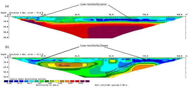
This study utilizes the electrical resistivity values obtained using 2-D Electrical resistivity imaging (ERI) technique to evaluate the subsurface lithology across different geological units. The primary objective was to determine the effect of subsurface lithology on the integrity of a road pavement, which had developed cracks and potholes at various locations. The dipole-dipole configuration was utilized and a total of nine traverses were established in the study area, whose geology cuts across both the basement and sedimentary complexes. The inverted resistivity section obtained showed significant variation in resistivity along established traverses and also across the different rock units, with the resistivity value ranging from about 4 ohm-m to greater than 7000 ohm- m. The lithology as interpreted from the resistivity section revealed the presence topsoil, clay, sandy clay, sand, sand stones/basement rocks, with varying vertical and horizontal arrangements to a depth of 40m. Results suggest that the geologic sequence and structure might have contributed to the observed pavement failure. The capability of the 2D ERI as an imaging tool is observed, especially across the transition zones as depicted in this study. The study further stressed the ability of this technique if properly designed and implemented, to be capable of providing a wealth of information that could complement other traditional geotechnical and geologic techniques.
Downloads
References
Adiat, K., Adelusi, A., & Ayuk, M. 2009. Relevance of Geophysics in Road Failures Investigation in a Typical Basement Complex of Southwestern Nigeria. Pacific Journal of Science and Technology, 51, 528-539.
Ajayi, L. 1987. Thought on road failures in Nigeria. The Nigerian Engineer, 221, 10-17.
Alaia, R., Patella, D., & Mauriello, P. 2007. Application of geoelectrical 3D probability tomography in a test-site of the archaeological park of Pompei Naples, Italy. Journal of Geophysics and Engineering, 51, 67.
Anderson, N. L., Croxton, N., Hoover, R., & Sirles, P. 2008. Geophysical methods commonly employed for geotechnical site characterization. Transportation Research E-CircularE-C130.
Ariyo, S., & Adeyemi, G. 2012. Geo-electrical Characterization of Aquifers in the Basement Complex/Sedimentary transition zone, Southwestern Nigeria. International journal of advanced scientific research and technology, 21.
Ayolabi, E., & Adegbola, R. 2014. Application of MASW in road failure investigation. Arabian Journal of Geosciences, 710, 4335-4341.
Emujakporue, O. 2012. Geophysical Investigation Of The Causes Of Highway Failures In Niger Delta Sedimentary Basin A Case Study Of The Eastern Part Of East-West Road, Nigeria. Scientia Africana, 111, 143-152.
Igwe, O. 2015. The causes and mechanisms of rain-induced highway and pavement collapse in Obolo-eke, Southeast Nigeria. Arabian Journal of Geosciences, 811, 9845-9855.
K.O, O. 2012. Combination of geological mapping and geophysical surveys for surface-subsurface structures imaging in Mini-Campus and Methodist Ago-Iwoye NE Areas, Southwestern Nigeria. Journal of Geology and Mining Research, 45. doi:10.5897/jgmr12.001
Kumar, D. 2012. Efficacy of electrical resistivity tomography technique in mapping shallow subsurface anomaly. Journal of the Geological Society of India, 803, 304-307.
Loke, M. 2004. Tutorial: 2-D and 3-D Electrical Imaging Surveys, 2004 Revised Edition.
Metwaly, M., & AlFouzan, F. 2013. Application of 2-D geoelectrical resistivity tomography for subsurface cavity detection in the eastern part of Saudi Arabia. Geoscience Frontiers, 44, 469-476.
Momoh, L., Akintorinwa, O., & Olorunfemi, M. 2008. Geophysical Investigation of Highway Failure-A Case Study from the Basement Complex Terrain of Southwestern Nigeria.
Oladapo, M. I., Obafemi, M., & Ojo, S. 2008. Geophysical investigation of road failures in the basement complex areas of southwestern Nigeria. Research Journal of Applied Sciences, 32, 103-112.
Olayinka, A., & Sogbetun, A. 2002. Laboratory measurement of the electrical resistivity of some Nigerian crystalline basement complex rocks. African Journal of Science and Technology, 31.
Olorunfemi, M., & Meshida, E. 1987. Engineering geophysics and its application in engineering site investigations Case study from Ile-Ife area. The Nigerian Engineer, 222, 57-66.
Omatsola, M., & Adegoke, O. 1981. Tectonic evolution and Cretaceous stratigraphy of the Dahomey Basin. Journal of Mining and Geology, 181, 130-137.
Onuoha, D. C. O., S. U. and Obienusi, E. A. 2014. Evaluating the Causes of the Road Failure of Onitsha-Enugu Expressway, Southeastern Nigeria. Civil and Environmental Research ISSN 2224-5790 Paper ISSN 2225-0514 Online Vol.6, No.8, pp. 1118-130.
Rahman, M. 1989. Review of the Basement Geology of Southwest. Nigeria. Geol. Nigeria, 943-959.
Rizzo, E., Chianese, D., & Lapenna, V. 2005. Integration of magnetometric, gpr and geoelectric measurements applied to the archaeological site of Viggiano Southern Italy, Agri Valley-Basilicata. Near Surface Geophysics, 3, 13-19.
Sobreira, J. F. F., Lipski, M., Carvalho, L. A., & Márquez, E. 2010. Geotechnical characterization based on seismic data approaches applied in Campos Basin, southeastern Brazilian Margin. The Leading Edge, 297, 842-846.
Wightman, W., Jalinoos, F., Sirles, P., & Hanna, K. 2004. Application of geophysical methods to highway related problems. Retrieved from www.cflhd.gov/agm/index.htm.
Downloads
Published
Issue
Section
License
Copyright @2019. This is an open-access article distributed under the terms of the Creative Commons Attribution-ShareAlike 4.0 International License which permits unrestricted use, distribution, and reproduction in any medium. Copyrights of all materials published in JGEET are freely available without charge to users or / institution. Users are allowed to read, download, copy, distribute, search, or link to full-text articles in this journal without asking by giving appropriate credit, provide a link to the license, and indicate if changes were made. All of the remix, transform, or build upon the material must distribute the contributions under the same license as the original.


