Geology Of Tanjung Medan ,Rokan IV Koto , Rokan Hulu District, Riau Province
DOI:
https://doi.org/10.24273/jgeet.2018.3.2.1597Keywords:
Rokan Hulu, Intrusion, Granite, Arenite SandstoneAbstract
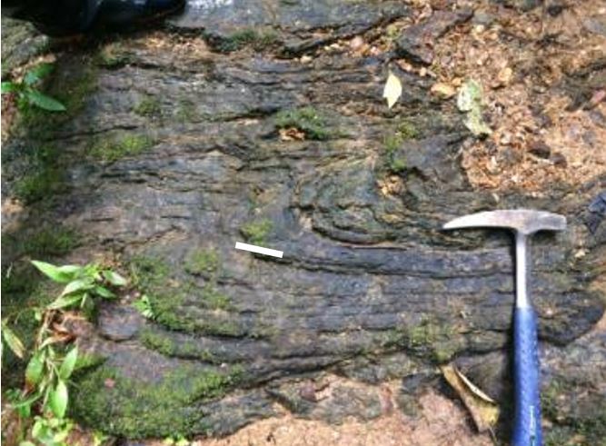
The Administrative of research area has been in Tanjung Medan, Rokan IV Koto, Rokan Hulu, Riau Province and geographically located at 0 ° 37 '28.488 "- 0 ° 40' 10.3692" LU and 100 ° 24 '55.6884 "- 100 ° 27 '37.5804 "BT. Research method used approach method and laboratory analysis to get data of geology modeling and re-construction of geological history in research area. Based on surface observation, the geology of research area consists of Slate (Permian-carbon), Granite intrusion (Permian-Trias) with distribution SouthWest-SouthEast on the center of map. Arenite Sandstone unit (Easly Eocene) unconformity with slate on the bottom. Alluvial Rokan river crosses all type off rocks from north to south of map. While structure growth in the research area have been joints structure with main stress Southwest-NorthEast, its similar with trend tectonic setting of Sumatra island, on the other hand reverse fault indicates the formation of a basin of extension stress in the early Eocene. the formation of basins in basement rocks begun at the time of the formation of the north-south trending northern form of the fault block forming horst and graben as well as accommodated the precipitation of pre-tertiary clastic materials. Whereas the Oligocene trans-tensional compression system accommodating the sedimentation system in the formed of arenite sandstone (SBPa) unconformity above the basement rocks simultaneously on the basin base decrease. The distribution of arenite sandstones based on the geological reconstruction covering all parts of the rock distribution which then undergoes the same weathering process of the formation of Bukit Barisan volcanic path that controls the development of geological structure up to the present.
Downloads
References
Dunham, R.J. 1962. Spectral Subdivision of Limestone Type. W.E Ham (Ed), classification of carbonate rocks, Am.Assoc.Pet.Mem,1,hlm 62 - 84.
Eubank and Makki, 1981, Structural Geology of The Central Sumatra Back-Arc Basin, Jakarta : Indonesian Petroleum Association.
Heidrick, T.L., Aulia, K., 1993. A structural and Tectonic Model of The Coastal Plain Blovk, Central Sumatera Basin, Indonesia. Indonesian Petroleum Association, Proceeding 22 Annual Convection, Jakarta, Vol. 1,p. 285-316.
Hindartan and Handayana, A., 1994. Pemetaan Geomorfologi Sistematis untuk Studi Geologi, PIT – IAGI ke 23.
Kausarian, H., Choanji, T., Karya, D., Kadir, E.A., Suryadi, A., 2018. Geological Mapping of Silica Sand Distribution on the Muda Island and Ketam Island, Estuary of Kampar River, Indonesia - Proceedings of the Second International Conference on the Future of ASEAN (ICoFA) 2017 – Volume 2, Singapore, pp. 973–982.
N.M.S. Rock, D.T. Aldiss, J.A. Aspden, M.C.G. Clarke, A. Djunuddin, W. Kartawa, Miswar, S.J. Thompson, R. Whandoyo., 1983. Peta geologi Pekanbaru,
Pettijohn, F.J. 1975. Sedimentary Rock. Marker and Bow Publisher. Third Edition.
Prayitno, B., 2016. Limnic Condition In Rheotrhopic Peat Type As the Origin of Petai Coal , Central Sumatra Basin , Indonesia. Journal of Geoscience, Engineering, Environment, and Technology, 1, 63-69.
Prayitno, B., & Ningrum, N. S., 2017. Development of Funginite on Muaraenim and Lower Members of Telisa Formations at Central Sumatra Basin - Indonesia. Journal of Geoscience, Engineering, Environment, and Technology 2(2), 149-145.
Streckeisen, A. 1976. To Each Plutonic Rock its Proper Name. Earth Sci. Rev.,12. hlm:1-34.
Van Zuidam, R.A., 1985, Aerial Photo Interpretation in Terrain Analysis and Geomorphologic Mapping, The Hague: Smits.
Yarmanto dan Aulia, K., 1988, The Seismic Expression of Wrench Tectonic in the Central Sumatra Basin : IAGI Seventeenth Annual Convention, Jakarta, p.35.
Yuskar, Y., Putra, D. B. E., Suryadi, A., Choanji, T., & Cahyaningsih, C., 2017. Structural Geology Analysis In A Disaster-Prone Of Slope Failure, Merangin Village, Kuok District, Kampar Regency, Riau Province. Journal of Geoscience, Engineering, Environment, and Technology, 2, 249-254.
Zakaria, Z., 2005, Sesar Cimandiri bagian timur dan implikasinya terhadap longsoran di Citatah, Padalarang, Jawa Barat, Majalah Geologi Indonesia, Vol. 20, No. 1,April 2005,hal 41-50.
Downloads
Published
Issue
Section
License
Copyright @2019. This is an open-access article distributed under the terms of the Creative Commons Attribution-ShareAlike 4.0 International License which permits unrestricted use, distribution, and reproduction in any medium. Copyrights of all materials published in JGEET are freely available without charge to users or / institution. Users are allowed to read, download, copy, distribute, search, or link to full-text articles in this journal without asking by giving appropriate credit, provide a link to the license, and indicate if changes were made. All of the remix, transform, or build upon the material must distribute the contributions under the same license as the original.