
Spatial Statistical Analysis for Potential Transit Oriented Development (TOD) in Jakarta Metropolitan Region
DOI:
https://doi.org/10.24273/jgeet.2018.3.01.1091Keywords:
Transit Oriented Development (TOD), Geographic Information System (GIS), Analytical Hierarchy Process (AHP), Spatial Statistical Analysis, Jakarta Metropolitan Region (JMR)Abstract
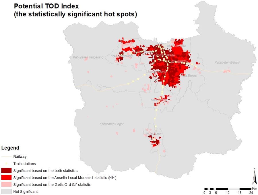
Spatial planning on Transit Oriented Development (TOD) concerns with the integration between land use and transportation aspects. However, in some places, public transport management based on transit nodes such as train services which are not well- integrated, and causing spatial chaos, especially surrounding station areas. It is essential to prepare a public transportation plan by maximizing regional potential capacity with TOD model. The purpose of this paper is to identify and prioritize potential areas for TOD using spatial statistical analysis with combined models of Geographic Information System (GIS) and Analytical Hierarchy Process (AHP) for Jakarta Metropolitan Regional (JMR), Indonesia. This paper employed two major indicators: main- and sub-indicators depending on relevant references. The weight of each indicator was determined by chosen experts. The result showed that some of the metro areas of Jakarta were highly suitable for TOD and indicated the characteristics of the development of urban areas. This paper’s outcome was useful in order to determine the potential location of TOD and was applicable to other areas within the same geographical conditions.
Downloads
References
Binglei, X., Chuan, D., 2013. An Evaluation on Coordinated Relationship between Urban Rail Transit and Land-use under TOD Mode. J. Transp. Syst. Eng.
Black, J., Tara, K., Pakzad, P., 2016. Planning and Design Elements for Transit Oriented Developments/Smart Cities: Examples of Cultural Borrowings. Procedia Eng.
FAO, 1976. A framework for land evaluation, FAO soils bulletin n.32. doi:M-51
Fard, P., 2013. Measuring Transit Oriented Development: Implementing a GIS-based analytical tool for measuring existing TOD levels. Fac. Geo-Information Sci. Earth Obs. Univ. Twente.
Feudo, F., 2014. How to Build an Alternative to Sprawl and Auto-centric Development Model through a TOD Scenario for the North-Pas-de-Calais Region? Lessons from an. Transp. Res. Procedia.
Galelo, A., Ribeiro, A., Martinez, L., 2014. Measuring and Evaluating the Impacts of TOD Measures–Searching for Evidence of TOD Characteristics in Azambuja Train Line. Procedia-Social Behav.
Hasibuan, H., Soemardi, T., 2014. The role of transit oriented development in constructing urban environment sustainability, the case of Jabodetabek, Indonesia. Procedia Environ.
Javadian, M., Shamskooshki, H., Momeni, M., 2011. Application of Sustainable Urban Development in Environmental Suitability Analysis of Educational Land Use by Using Ahp and Gis in Tehran. Procedia Eng. 21, 72–80. doi:10.1016/j.proeng.2011.11.1989.
Lubis, M.Z., Anurogo, W., Gustin, O., Hanafi, A., Timbang, D., Rizki, F., Saragih, D.A., Kartini, I.I., Panjaitan, H.C., Yanti, M.T., 2017. Interactive modelling of buildings in Google Earth and GIS: A 3D tool for Urban Planning (Tunjuk Island, Indonesia). J. Appl. Geospatial Inf. 1, 44–48.
Lubis, M.Z., Taki, H.M., Anurogo, W., Pamungkas, D.S., Wicaksono, P., Aprilliyanti, T., 2017. Mapping the Distribution of Potential Land Drought in Batam Island Using the Integration of Remote Sensing and Geographic Information Systems (GIS), in: IOP Conference Series: Earth and Environmental Science. IOP Publishing, p. 12012.
Mohajeri, N., Amin, G.R., 2010. Author’s personal copy Railway station site selection using analytical hierarchy process and data envelopment analysis.
Nguyen, T.T., Verdoodt, A., Van Y, T., Delbecque, N., Tran, T.C., Van Ranst, E., 2015. Design of a GIS and multi-criteria based land evaluation procedure for sustainable land-use planning at the regional level. Agric. Ecosyst. Environ. doi:10.1016/j.agee.2014.10.015.
Olaru, D., Smith, B., Taplin, J., 2011. Residential location and transit-oriented development in a new rail corridor. Transp. Res. Part A Policy.
Prasertsubpakij, D., Nitivattananon, V., 2012. Evaluating accessibility to Bangkok Metro Systems using multi-dimensional criteria across user groups. IATSS Res.
Ratner, K., Goetz, A., 2013. The reshaping of land use and urban form in Denver through transit-oriented development. Cities.
Saaty, T., 1990. How to make a decision: the analytic hierarchy process. Eur. J. Oper. Res.
Singh, Y., Fard, P., Zuidgeest, M., 2014. Measuring transit oriented development: a spatial multi criteria assessment approach for the City Region Arnhem and Nijmegen. J. Transp.
Statistik, B.P., 2011. Jumlah Penduduk Indonesia.
Sunarto, Retno Sari, 2009. Undelivering Service Quality in Public Transport - Case of:commuter Railway of Jabodetabek.
Taki, H., Lubis, M., 2017. Modeling accessibility of community facilities using GIS: case study of Depok City, Indonesia. J. Appl. Geospatial Inf.
Taki, H.M., 2017. Slum Revitalizing Plan of Baghdadiyah By Spatial Re-Modeling Configuration. Geoplanning J. Geomatics Plan. 0. doi:10.14710/Geoplanning.0.0.%p.
Taki, H.M., Maatouk, M.M.H., Qurnfulah, E.M., 2017a. Re-Assessing TOD index in Jakarta Metropolitan Region (JMR). J. Appl. Geospatial Inf. 1, 26–35.
Taki, H.M., Maatouk, M.M.H., Qurnfulah, E.M., Aljoufie, M.O., 2017b. Planning TOD with land use and transport integration: a review. J. Geosci. Eng. Environ. Technol. 2, 84. doi:10.24273/jgeet.2017.2.1.17.
Vale, D., 2015. Transit-oriented development, integration of land use and transport, and pedestrian accessibility: Combining node-place model with pedestrian shed ratio to evaluate. J. Transp. Geogr.
Downloads
Additional Files
Published
Issue
Section
License
Copyright @2019. This is an open-access article distributed under the terms of the Creative Commons Attribution-ShareAlike 4.0 International License which permits unrestricted use, distribution, and reproduction in any medium. Copyrights of all materials published in JGEET are freely available without charge to users or / institution. Users are allowed to read, download, copy, distribute, search, or link to full-text articles in this journal without asking by giving appropriate credit, provide a link to the license, and indicate if changes were made. All of the remix, transform, or build upon the material must distribute the contributions under the same license as the original.


